FAA INFORMATION EFFECTIVE 30 OCTOBER 2025
Location
| FAA Identifier: | A34 |
| Lat/Long: | 39-14-18.3000N 119-33-19.6000W
39-14.305000N 119-33.326667W
39.2384167,-119.5554444
(estimated) |
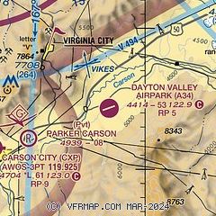
| Elevation: | 4414.3 ft. / 1345.5 m (surveyed) |
| Variation: | 16E (1985) |
| From city: | 2 miles E of central business district of the associated city |
| Time zone: | UTC -8 (UTC -7 during Daylight Saving Time) |
| Zip code: | 89403 |
Airport Operations
| Airport use: | Open to the public |
| Activation date: | 10/1988 |
| Control tower: | no |
| ARTCC: | OAKLAND CENTER |
| FSS: | RENO FLIGHT SERVICE STATION |
| NOTAMs facility: | RNO (NOTAM-D service available) |
| Attendance: | UNATNDD |
| Wind indicator: | yes |
| Segmented circle: | yes |
Airport Communications
| CTAF: | 122.9 |
| WX AWOS-3PT at CXP (9 nm W): | 119.925 (775-884-4708) |
| WX AWOS-3PT at MEV (17 nm SW): | 119.325 (775-782-6264) |
| WX AWOS-2 at SPZ (17 nm NE): | 120.475 (775-577-2624) |
| WX ASOS at RNO (18 nm NW): | 135.8 (775-432-6755) |
Nearby radio navigation aids
| VOR radial/distance | | VOR name | | Freq | | Var |
|---|
| FMGr149/18.2 | | MUSTANG VORTAC | | 117.90 | | 16E |
| HZNr220/30.8 | | HAZEN VORTAC | | 114.10 | | 17E |
| SWRr068/33.4 | | PALISADES VOR/DME | | 113.20 | | 16E |
Airport Services
Runway Information
Runway 5/23
| Dimensions: | 5343 x 75 ft. / 1629 x 23 m |
| Surface: | asphalt, in good condition |
| Weight bearing capacity: | | Single wheel: | 12.5 | | Double wheel: | 12.5 |
|
| RUNWAY 5 | | RUNWAY 23 |
| Latitude: | 39-14.119342N | | 39-14.491665N |
| Longitude: | 119-33.839815W | | 119-32.814583W |
| Elevation: | 4414.3 ft. | | 4372.4 ft. |
| Traffic pattern: | right | | left |
| Runway heading: | 049 magnetic, 065 true | | 229 magnetic, 245 true |
| Displaced threshold: | 991 ft. | | no |
| Markings: | basic, in good condition | | basic, in good condition |
| Runway end identifier lights: | no | | no |
| Touchdown point: | yes, no lights | | yes, no lights |
| Obstructions: | 193 ft. tower, lighted, 3470 ft. from runway, 434 ft. right of centerline, 16:1 slope to clear
APCH SLOPE 23:1 TO DSPLCD THR. | | none |
Airport Ownership and Management from official FAA records
| Ownership: | Privately-owned |
| Owner: | AIRPARK ESTATES HOMEOWNERS ASSN.
399 ARMSTRONG COURT
DAYTON, NV 89403
Phone (575) 644-2549 |
| Manager: | DEAN PATMOR
409 ARMSTRONG COURT
DAYTON, NV 89403
Phone (818) 519-7133 |
Additional Remarks
| - | NOISE ABATEMENT: SMALL ACFT 0.75 NM S 5414 FT MSL/1000 FT AGL; JETS & LRG ACFT 1.75 NM S 6414 FT MSL/2000 FT AGL; EXTD TKOF BYD SCHOOLS & RESIDENTIAL AREAS. |
| - | WILD HORSES, MIGRATORY BIRDS, AND WATERFOWL ON AND INVOF ARPT. |
| - | FICON & PPR - AMGR OR 575-644-2549. |
| - | PPR OVR 12500 LBS, BANNER TOWING, SKYDIVING, UAV/UAS, PWR PRCHT & GLDR OPS - AMGR OR 575-644-2549. |
| - | FOR CD CTC NORCAL APCH AT 916-361-0596. |
| - | FOR GND TRANSPORTATION SVCS CALL (775) 447-3600. |
| - | CTN: DEEP DITCH IN RSA & RWY SHOULDER SE CORNER OF RWY. |
Instrument Procedures
There are no published instrument procedures at A34.
Some nearby airports with instrument procedures:
KCXP - Carson City Airport (9 nm W)
KMEV - Minden-Tahoe Airport (17 nm SW)
KSPZ - Silver Springs Airport (17 nm NE)
KRNO - Reno/Tahoe International Airport (18 nm NW)
O43 - Yerington Municipal Airport (23 nm SE)
|
|

Road maps at:
MapQuest
Bing
Google
| Aerial photo |
|---|
WARNING: Photo may not be current or correct
 Photo by Greg Chico
Photo taken 09-Feb-2007
Photo by Greg Chico
Photo taken 09-Feb-2007
Do you have a better or more recent aerial photo of Dayton Valley Airpark that you would like to share? If so, please send us your photo.
|
| Sectional chart |
|---|
|
| Airport distance calculator |
|---|
|
|
| Sunrise and sunset |
|---|
|
Times for 21-Nov-2025
| | Local
(UTC-8) | | Zulu
(UTC) |
|---|
| Morning civil twilight | | 06:20 | | 14:20 |
| Sunrise | | 06:49 | | 14:49 |
| Sunset | | 16:39 | | 00:39 |
| Evening civil twilight | | 17:08 | | 01:08 |
|
| Current date and time |
|---|
| Zulu (UTC) | 21-Nov-2025 11:51:01 |
|---|
| Local (UTC-8) | 21-Nov-2025 03:51:01 |
|---|
|
| METAR |
|---|
KCXP
9nm W | 211115Z AUTO 06007G14KT 10SM OVC015 04/03 A3007 RMK AO2
|
KMEV
17nm SW | 211115Z AUTO 04010KT 10SM BKN035 BKN044 04/02 A3002 RMK AO2
|
KRNO
18nm NW | 211055Z 06004KT 10SM SCT020 BKN035 OVC050 05/03 A3005 RMK AO2 RAB37E47 SLP173 P0000 T00500028 $
|
|
| TAF |
|---|
KCXP
9nm W | 210954Z 2110/2206 VRB04KT P6SM VCFG BKN015 OVC020 FM211600 VRB05KT P6SM BKN060 FM211900 08009KT P6SM SCT100 FM220100 VRB05KT P6SM SCT180
|
KMEV
17nm SW | 210958Z 2110/2206 VRB06KT P6SM VCFG BKN030 OVC050 TEMPO 2112/2116 5SM BR SCT005 FM211700 06006KT P6SM BKN080 FM220000 VRB04KT P6SM SCT180
|
KRNO
18nm NW | 210953Z 2110/2206 VRB05KT P6SM VCFG OVC020 FM211700 VRB05KT P6SM BKN080 FM212200 VRB05KT P6SM SCT100
|
|
| NOTAMs |
|---|
NOTAMs are issued by the DoD/FAA and will open in a separate window not controlled by AirNav.
|
|

