FAA INFORMATION EFFECTIVE 27 NOVEMBER 2025
Location
| FAA Identifier: | AMN |
| Lat/Long: | 43-19-19.7110N 084-41-16.5790W
43-19.328517N 084-41.276317W
43.3221419,-84.6879386
(estimated) |
| Elevation: | 754.1 ft. / 229.8 m (surveyed) |
| Variation: | 05W (1990) |
| From city: | 3 miles SW of ALMA, MI |
| Time zone: | UTC -5 (UTC -4 during Daylight Saving Time) |
| Zip code: | 48801 |
Airport Operations
| Airport use: | Open to the public |
| Control tower: | no |
| ARTCC: | CLEVELAND CENTER |
| FSS: | LANSING FLIGHT SERVICE STATION |
| NOTAMs facility: | AMN (NOTAM-D service available) |
| Attendance: | MON-SAT 0830-1430 |
| Wind indicator: | lighted |
| Segmented circle: | yes |
| Lights: | ACTVT REIL RWY 09 & 27; PAPI RWY 09 & 27; MIRL RWY 09/27 & 18/36 - CTAF. |
| Beacon: | white-green (lighted land airport)
Operates sunset to sunrise. |
Airport Communications
| CTAF/UNICOM: | 122.8 |
| WX AWOS-3P: | 124.175 (989-463-3433) |
| GREAT LAKES APPROACH: | 126.45 |
| GREAT LAKES DEPARTURE: | 126.45 |
| WX AWOS-3 at MOP (18 nm N): | 133.025 (989-773-2885) |
- APCH/DEP SVC PRVDD BY CLEVELAND ARTCC (ZOB) ON FREQS 126.75/348.75 (FLINT RCAG) WHEN GREAT LAKES APCH CTL CLSD.
Nearby radio navigation aids
| VOR radial/distance | | VOR name | | Freq | | Var |
|---|
| MOPr178/18.2 | | MOUNT PLEASANT VOR/DME | | 110.60 | | 05W |
| MBSr248/29.4 | | SAGINAW VOR/DME | | 114.35 | | 03W |
Airport Services
| Fuel available: | 100LL JET-A+ |
| Parking: | hangars and tiedowns |
| Airframe service: | NONE |
| Powerplant service: | NONE |
| Bottled oxygen: | NONE |
| Bulk oxygen: | NONE |
Runway Information
Runway 9/27
| Dimensions: | 5004 x 75 ft. / 1525 x 23 m |
| Surface: | asphalt/grooved, in good condition |
| Weight bearing capacity: | | Single wheel: | 40.0 | | Double wheel: | 65.0 |
|
| Runway edge lights: | medium intensity |
| RUNWAY 9 | | RUNWAY 27 |
| Latitude: | 43-19.381320N | | 43-19.377747N |
| Longitude: | 084-41.762327W | | 084-40.634168W |
| Elevation: | 750.5 ft. | | 753.2 ft. |
| Traffic pattern: | left | | left |
| Runway heading: | 095 magnetic, 090 true | | 275 magnetic, 270 true |
| Markings: | nonprecision, in fair condition | | nonprecision, in fair condition |
| Visual slope indicator: | 4-light PAPI on left (3.00 degrees glide path) | | 4-light PAPI on left (3.00 degrees glide path) |
| Runway end identifier lights: | yes | | yes |
| Touchdown point: | yes, no lights | | yes, no lights |
| Instrument approach: | SDF | | |
| Obstructions: | 79 ft. tree, 2307 ft. from runway, 266 ft. left of centerline, 26:1 slope to clear | | none |
Runway 18/36
| Dimensions: | 3198 x 75 ft. / 975 x 23 m |
| Surface: | asphalt/grooved, in good condition |
| Weight bearing capacity: | |
| Runway edge lights: | medium intensity |
| RUNWAY 18 | | RUNWAY 36 |
| Latitude: | 43-19.511838N | | 43-18.985430N |
| Longitude: | 084-41.396863W | | 084-41.400050W |
| Elevation: | 753.2 ft. | | 754.0 ft. |
| Traffic pattern: | left | | left |
| Runway heading: | 185 magnetic, 180 true | | 005 magnetic, 000 true |
| Markings: | nonprecision, in fair condition | | nonprecision, in fair condition |
| Touchdown point: | yes, no lights | | yes, no lights |
| Obstructions: | 56 ft. tree, 1119 ft. from runway, 383 ft. left of centerline, 16:1 slope to clear | | none |
Airport Ownership and Management from official FAA records
| Ownership: | Publicly-owned |
| Owner: | CITY OF ALMA/CO OF GRATIOT
525 E SUPERIOR ST, PO BOX 278
ALMA, MI 48801
Phone 989-463-8336 |
| Manager: | SCOTT MCDONALD
3999 W SEAMAN RD
ALMA, MI 48801-9232
Phone 989-463-5500 |
Additional Remarks
| - | DEER & LRG BIRDS ON & INVOF ARPT. |
| - | ADMIN BLDG ACES, PRESS V, THEN III & II SIMUL, THEN I. |
| - | FOR CD CTC GREAT LAKES APCH AT 269-459-3345, WHEN APCH CLSD CTC CLEVELAND ARTCC AT 440-774-0224/0490. |
Instrument Procedures
NOTE: All procedures below are presented as PDF files. If you need a reader for these files, you should download the free Adobe Reader.NOT FOR NAVIGATION. Please procure official charts for flight.
FAA instrument procedures published for use from 27 November 2025 at 0901Z to 25 December 2025 at 0900Z.
IAPs - Instrument Approach Procedures |
|---|
| RNAV (GPS) RWY 09 | |
download (241KB) |
| RNAV (GPS) RWY 18 | |
download (171KB) |
| RNAV (GPS) RWY 27 | |
download (189KB) |
| VOR RWY 18 | |
download (185KB) |
| NOTE: Special Alternate Minimums apply | |
download (22KB) |
| NOTE: Special Take-Off Minimums/Departure Procedures apply | |
download (122KB) |
Other nearby airports with instrument procedures:
KMOP - Mount Pleasant Municipal Airport (18 nm N)
13C - Lakeview Airport/Griffith Field (26 nm W)
6D6 - Greenville Municipal Airport (27 nm SW)
KIKW - Jack Barstow Airport (28 nm NE)
Y70 - Ionia County Airport (28 nm SW)
|
|

Road maps at:
MapQuest
Bing
Google
| Aerial photo |
|---|
WARNING: Photo may not be current or correct
 Photo courtesy of AirNav, LLC
Photo taken 28-Jul-2011
looking north.
Photo courtesy of AirNav, LLC
Photo taken 28-Jul-2011
looking north.
Do you have a better or more recent aerial photo of Gratiot Community Airport that you would like to share? If so, please send us your photo.
|
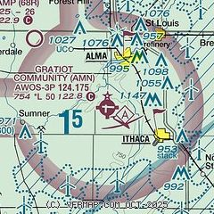
| Sectional chart |
|---|
|
| Airport distance calculator |
|---|
|
|
| Sunrise and sunset |
|---|
|
Times for 08-Dec-2025
| | Local
(UTC-5) | | Zulu
(UTC) |
|---|
| Morning civil twilight | | 07:27 | | 12:27 |
| Sunrise | | 07:59 | | 12:59 |
| Sunset | | 17:02 | | 22:02 |
| Evening civil twilight | | 17:34 | | 22:34 |
|
| Current date and time |
|---|
| Zulu (UTC) | 09-Dec-2025 00:33:20 |
|---|
| Local (UTC-5) | 08-Dec-2025 19:33:20 |
|---|
|
| METAR |
|---|
| KAMN | 090015Z AUTO 18001KT 10SM SCT095 M16/M18 A3028 RMK AO2
|
KMOP
18nm N | 090015Z AUTO 16003KT 10SM SCT100 M07/M14 A3027 RMK AO2 T10741142
|
|
| TAF |
|---|
KMBS
29nm NE | 081728Z 0818/0918 35006KT P6SM BKN250 FM082200 18005KT P6SM SCT100 FM090300 18003KT P6SM BKN200 FM091100 19012G22KT 2SM -SN BKN014 FM091600 22014G24KT 5SM -SN BR OVC012
|
KLAN
33nm S | 081806Z 0818/0918 VRB03KT P6SM BKN250 FM090800 19009KT P6SM OVC090 FM091100 19012G21KT P6SM VCSH OVC035 FM091200 20012G23KT 6SM -SHSN BR OVC024 WS020/22045KT FM091300 20013G24KT 5SM -SHSN BR OVC018 WS013/22030KT FM091500 22013G24KT 4SM -FZDZ BR OVC007
|
|
| NOTAMs |
|---|
NOTAMs are issued by the DoD/FAA and will open in a separate window not controlled by AirNav.
|
|

