FAA INFORMATION EFFECTIVE 11 JUNE 2026
Location
| FAA Identifier: | BRY |
| Lat/Long: | 37-48-51.6000N 085-29-58.7000W
37-48.860000N 085-29.978333W
37.8143333,-85.4996389
(estimated) |
| Elevation: | 668.8 ft. / 203.9 m (surveyed) |
| Variation: | 05W (2020) |
| From city: | 2 miles W of BARDSTOWN, KY |
| Time zone: | UTC -4 (UTC -5 during Standard Time) |
| Zip code: | 40004 |
Airport Operations
| Airport use: | Open to the public |
| Control tower: | no |
| ARTCC: | INDIANAPOLIS CENTER |
| FSS: | LOUISVILLE FLIGHT SERVICE STATION |
| NOTAMs facility: | LOU (NOTAM-D service available) |
| Attendance: | MON-SAT 0800-1700, ALL SUN UNATNDD
CALL OUT AVBL - 502-348-7858 (LANDLINE; RINGS OVER TO CELL). |
| Wind indicator: | lighted |
| Segmented circle: | yes |
| Lights: | ACTVT REIL RWY 03 & 21; PAPI RWY 03 & 21; MIRL RWY 3/21 - CTAF. |
| Beacon: | white-green (lighted land airport)
Operates sunset to sunrise. |
Airport Communications
| CTAF/UNICOM: | 122.8 |
| WX AWOS-3: | 119.925 (502-348-1867) |
| LOUISVILLE APPROACH: | 132.075 |
| LOUISVILLE DEPARTURE: | 132.075 |
| WX AWOS-3P at 6I2 (16 nm SE): | 119.725 (859-336-0340) |
Nearby radio navigation aids
| VOR radial/distance | | VOR name | | Freq | | Var |
|---|
| EWOr036/13.8 | | NEW HOPE VOR/DME | | 113.95 | | 01E |
| IIUr167/17.7 | | LOUISVILLE VORTAC | | 114.80 | | 01E |
| FTKr105/23.1 | | FORT KNOX VOR/DME | | 109.60 | | 01W |
| MYSr099/(35.6) | | MYSTIC VOR | | 108.20 | | 01W |
| FFTr235/(35.6) | | FRANKFORT VOR | | 109.40 | | 03W |
| NDB name | | Hdg/Dist | | Freq | | Var | | ID |
|---|
| GODMAN | | 114/24.2 | | 396 | | 03W | | GOI | --. --- .. |
| GOODALL | | 295/37.7 | | 311 | | 03W | | DVK | -.. ...- -.- |
Airport Services
| Fuel available: | 100LL JET-A+ |
| Parking: | hangars and tiedowns |
| Airframe service: | MINOR |
| Powerplant service: | MINOR |
| Bulk oxygen: | NONE |
Runway Information
Runway 3/21
| Dimensions: | 5003 x 75 ft. / 1525 x 23 m |
| Surface: | asphalt, in good condition |
| Weight bearing capacity: | | PCN 20 /F/C/X/T | | Single wheel: | 53.5 | | Double wheel: | 74.0 |
|
| Runway edge lights: | medium intensity |
| RUNWAY 3 | | RUNWAY 21 |
| Latitude: | 37-48.475910N | | 37-49.242782N |
| Longitude: | 085-30.168847W | | 085-29.787907W |
| Elevation: | 634.9 ft. | | 668.7 ft. |
| Traffic pattern: | left | | left |
| Runway heading: | 027 magnetic, 022 true | | 207 magnetic, 202 true |
| Markings: | nonprecision, in fair condition | | nonprecision, in fair condition |
| Visual slope indicator: | 2-light PAPI on left (3.50 degrees glide path) | | 2-light PAPI on left (3.00 degrees glide path) |
| Runway end identifier lights: | yes | | yes |
| Touchdown point: | yes, no lights | | yes, no lights |
| Obstructions: | 11 ft. pole, 251 ft. from runway, 251 ft. right of centerline, 4:1 slope to clear | | 70 ft. tree, 2354 ft. from runway, 322 ft. right of centerline, 30:1 slope to clear |
Airport Ownership and Management from official FAA records
| Ownership: | Publicly-owned |
| Owner: | BARDSTOWN/NELSON CO ARPT BOARD
1924 BOSTON ROAD
BARDSTOWN, KY 40004
Phone 502-827-0356
DAVID MATTINGLY |
| Manager: | REX HOUCK
1924 BOSTON ROAD
BARDSTOWN, KY 40004
Phone 502-348-7858
LANDLINE. |
Additional Remarks
| - | FOR CD CTC LOUISVILLE APCH AT 502-375-7499 |
Instrument Procedures
NOTE: All procedures below are presented as PDF files. If you need a reader for these files, you should download the free Adobe Reader.NOT FOR NAVIGATION. Please procure official charts for flight.
FAA instrument procedures published for use from 11 June 2026 at 0901Z to 09 July 2026 at 0900z.
IAPs - Instrument Approach Procedures |
|---|
| RNAV (GPS) RWY 03 | |
download (195KB) |
| RNAV (GPS) RWY 21 | |
download (225KB) |
| NOTE: Special Alternate Minimums apply **CHANGED** | |
download (143KB) |
| NOTE: Special Take-Off Minimums/Departure Procedures apply | |
download (366KB) |
Other nearby airports with instrument procedures:
6I2 - Lebanon Springfield Airport/George Hoerter Field (16 nm SE)
KEKX - Addington Field Airport (22 nm W)
KFTK - Godman Army Airfield (23 nm W)
KSDF - Louisville Muhammad Ali International Airport (24 nm NW)
KLOU - Bowman Field Airport (26 nm N)
|
|

Road maps at:
MapQuest
Bing
Google
| Aerial photo |
|---|
WARNING: Photo may not be current or correct
 Photo taken 27-Nov-2008
looking north-northeast.
Photo taken 27-Nov-2008
looking north-northeast.
Do you have a better or more recent aerial photo of Samuels Field Airport that you would like to share? If so, please send us your photo.
|
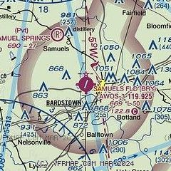
| Sectional chart |
|---|
|
| Airport distance calculator |
|---|
|
|
| Sunrise and sunset |
|---|
|
Times for 13-Jun-2026
| | Local
(UTC-4) | | Zulu
(UTC) |
|---|
| Morning civil twilight | | 05:49 | | 09:49 |
| Sunrise | | 06:20 | | 10:20 |
| Sunset | | 21:04 | | 01:04 |
| Evening civil twilight | | 21:35 | | 01:35 |
|
| Current date and time |
|---|
| Zulu (UTC) | 13-Jun-2026 14:47:18 |
|---|
| Local (UTC-4) | 13-Jun-2026 10:47:18 |
|---|
|
| METAR |
|---|
| KBRY | 131435Z AUTO 20004KT 10SM CLR 25/20 A3003 RMK AO2 T02530195
|
K6I2
16nm SE | 131435Z AUTO 20003KT 10SM CLR 28/17 A3006 RMK AO2
|
KEKX
18nm W | 131435Z AUTO 00000KT 10SM CLR 26/18 A3004 RMK AO2 T02550184
|
|
| TAF |
|---|
KFTK
23nm W | 121905Z 1219/1401 30007KT 9999 VCSH SCT025 BKN250 QNH2992INS BECMG 1300/1301 19007KT 9999 NSW FEW030 SCT250 QNH2990INS TEMPO 1307/1313 4800 BR BECMG 1321/1322 22007KT 9000 -RA VCTS BKN025CB OVC250 QNH2987INS TEMPO 1322/1324 4800 TSRA OVC015CB BECMG 1400/1401 19006KT 9999 NSW BKN025 OVC250 QNH2985INS TX30/1319Z TN16/1311Z LAST NO AMDS AFT 1221 NEXT 1511
|
KSDF
25nm NW | 131120Z 1312/1418 00000KT P6SM SKC FM131500 17004KT P6SM FEW250 FM131800 22005KT P6SM SCT250 PROB30 1402/1406 -TSRA BKN100CB FM140600 19008KT 3SM -TSRA BKN080CB FM140900 19008KT P6SM -TSRA BKN035CB FM141200 19008KT P6SM BKN025
|
|
| NOTAMs |
|---|
NOTAMs are issued by the DoD/FAA and will open in a separate window not controlled by AirNav.
|
|


