FAA INFORMATION EFFECTIVE 09 JULY 2026
Location
| FAA Identifier: | EKX |
| Lat/Long: | 37-41-09.6000N 085-55-30.1000W
37-41.160000N 085-55.501667W
37.6860000,-85.9250278
(estimated) |
| Elevation: | 775.9 ft. / 236.5 m (surveyed) |
| Variation: | 03W (2005) |
| From city: | 4 miles W of ELIZABETHTOWN, KY |
| Time zone: | UTC -4 (UTC -5 during Standard Time) |
| Zip code: | 42701 |
Airport Operations
| Airport use: | Open to the public |
| Activation date: | 06/1982 |
| Control tower: | no |
| ARTCC: | INDIANAPOLIS CENTER |
| FSS: | LOUISVILLE FLIGHT SERVICE STATION |
| NOTAMs facility: | LOU (NOTAM-D service available) |
| Attendance: | MON-FRI 0800-1800, ALL SAT-SUN 0900-1700 |
| Wind indicator: | lighted |
| Segmented circle: | yes |
| Lights: | ACTVT REIL RWY 05; MIRL RWY 05/23 - CTAF. PAPI RWY 05 & 23 OPR CONSLY. |
| Beacon: | white-green (lighted land airport)
Operates sunset to sunrise. |
Airport Communications
| CTAF/UNICOM: | 123.075 |
| WX AWOS-3: | 118.55 (270-763-6433) |
| LOUISVILLE APPROACH: | 123.675 |
| LOUISVILLE DEPARTURE: | 123.675 |
| CLEARANCE DELIVERY: | 119.45 |
Nearby radio navigation aids
| VOR radial/distance | | VOR name | | Freq | | Var |
|---|
| EWOr284/12.3 | | NEW HOPE VOR/DME | | 113.95 | | 01E |
| FTKr171/13.5 | | FORT KNOX VOR/DME | | 109.60 | | 01W |
| MYSr130/(19.6) | | MYSTIC VOR | | 108.20 | | 01W |
| IIUr212/30.0 | | LOUISVILLE VORTAC | | 114.80 | | 01E |
| NDB name | | Hdg/Dist | | Freq | | Var | | ID |
|---|
| GODMAN | | 174/16.5 | | 396 | | 03W | | GOI | --. --- .. |
Airport Services
| Fuel available: | 100LL JET-A+ |
| Parking: | hangars and tiedowns |
| Airframe service: | MAJOR |
| Powerplant service: | MAJOR |
Runway Information
Runway 5/23
| Dimensions: | 6001 x 100 ft. / 1829 x 30 m |
| Surface: | asphalt, in good condition |
| Weight bearing capacity: | | PCN 21 /F/C/X/T | | Single wheel: | 50.0 | | Double wheel: | 77.0 |
|
| Runway edge lights: | medium intensity |
| RUNWAY 5 | | RUNWAY 23 |
| Latitude: | 37-40.820802N | | 37-41.499860N |
| Longitude: | 085-55.954193W | | 085-55.049938W |
| Elevation: | 750.4 ft. | | 775.6 ft. |
| Traffic pattern: | left | | left |
| Runway heading: | 050 magnetic, 047 true | | 230 magnetic, 227 true |
| Markings: | precision, in good condition | | nonprecision, in good condition |
| Visual slope indicator: | 4-light PAPI on left (3.00 degrees glide path) | | 4-light PAPI on left (3.00 degrees glide path) |
| Runway end identifier lights: | yes | | no |
| Touchdown point: | yes, no lights | | yes, no lights |
| Instrument approach: | ILS/DME | | |
| Obstructions: | 10 ft. trees, 299 ft. from runway, 214 ft. left of centerline, 9:1 slope to clear | | 10 ft. trees, 447 ft. from runway, 552 ft. left of centerline, 24:1 slope to clear |
Airport Ownership and Management from official FAA records
| Ownership: | Publicly-owned |
| Owner: | ELIZABETHTOWN AIRPORT BOARD
1828 KITTY HAWK DR
ELIZABETHTOWN, KY 42701
Phone 270-737-8388
DONALD WISE. |
| Manager: | ROGER LAWSON
1828 KITTY HAWK DRIVE
ELIZABETHTOWN, KY 42701
Phone 270-737-8388
270-769-9100. |
Additional Remarks
| - | PAJA, BIRDS ON & INVOF ARPT. |
| - | FOR CD CTC LOUISVILLE APCH AT 502-375-7499 |
| - | TWY D CLSD TO ACFT WITH WINGSPAN MORE THAN 50 FT OR MORE THAN 12500 LBS GWT. |
| - | AFT HR - 270-766-8420. FUEL AVBL H24 WITH CREDIT CARD. |
Instrument Procedures
NOTE: All procedures below are presented as PDF files. If you need a reader for these files, you should download the free Adobe Reader.NOT FOR NAVIGATION. Please procure official charts for flight.
FAA instrument procedures published for use from 09 July 2026 at 0901Z to 06 August 2026 at 0900Z.
IAPs - Instrument Approach Procedures |
|---|
| ILS OR LOC RWY 05 **CHANGED** | |
download (233KB) |
| RNAV (GPS) RWY 05 **CHANGED** | |
download (191KB) |
| RNAV (GPS) RWY 23 **CHANGED** | |
download (156KB) |
| VOR-A **CHANGED** | |
download (207KB) |
| NOTE: Special Alternate Minimums apply | |
download (136KB) |
| NOTE: Special Take-Off Minimums/Departure Procedures apply | |
download (359KB) |
Other nearby airports with instrument procedures:
KFTK - Godman Army Airfield (13 nm N)
KBRY - Samuels Field Airport (22 nm E)
M20 - Leitchfield-Grayson County Airport (23 nm SW)
I93 - Breckinridge County Airport (25 nm W)
KSDF - Louisville Muhammad Ali International Airport (31 nm N)
|
|

Road maps at:
MapQuest
Bing
Google
| Aerial photo |
|---|
WARNING: Photo may not be current or correct
 Photo by Dick Booher
Taken in the Summer of 2014
looking north.
Photo by Dick Booher
Taken in the Summer of 2014
looking north.
Do you have a better or more recent aerial photo of Addington Field Airport that you would like to share? If so, please send us your photo.
|
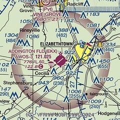
| Sectional chart |
|---|
|
| Airport distance calculator |
|---|
|
|
| Sunrise and sunset |
|---|
|
Times for 12-Jul-2026
| | Local
(UTC-4) | | Zulu
(UTC) |
|---|
| Morning civil twilight | | 06:02 | | 10:02 |
| Sunrise | | 06:33 | | 10:33 |
| Sunset | | 21:06 | | 01:06 |
| Evening civil twilight | | 21:36 | | 01:36 |
|
| Current date and time |
|---|
| Zulu (UTC) | 13-Jul-2026 01:28:04 |
|---|
| Local (UTC-4) | 12-Jul-2026 21:28:04 |
|---|
|
| METAR |
|---|
KEKX
3nm NE | 130115Z AUTO 00000KT 10SM CLR 25/22 A3004 RMK AO2 T02470215
|
KFTK
12nm N | 130055Z AUTO 06005KT 10SM CLR 26/23 A3004 RMK AO2 LTG DSNT S SLP168 T02610227
|
|
| NOTAMs |
|---|
NOTAMs are issued by the DoD/FAA and will open in a separate window not controlled by AirNav.
|
|

