FAA INFORMATION EFFECTIVE 11 JUNE 2026
Location
| FAA Identifier: | M20 |
| Lat/Long: | 37-23-59.1000N 086-15-40.6000W
37-23.985000N 086-15.676667W
37.3997500,-86.2612778
(estimated) |
| Elevation: | 782 ft. / 238.4 m (surveyed) |
| Variation: | 04W (2020) |
| From city: | 4 miles SE of LEITCHFIELD, KY |
| Time zone: | UTC -5 (UTC -6 during Standard Time) |
| Zip code: | 42754 |
Airport Operations
| Airport use: | Open to the public |
| Activation date: | 05/1978 |
| Control tower: | no |
| ARTCC: | INDIANAPOLIS CENTER |
| FSS: | LOUISVILLE FLIGHT SERVICE STATION |
| NOTAMs facility: | LOU (NOTAM-D service available) |
| Attendance: | UNATTENDED |
| Wind indicator: | lighted |
| Segmented circle: | yes |
| Lights: | ACTVT REIL RWY 02 & 20; PAPI RWY 02 & 20; MIRL RWY 02/20 - CTAF. |
| Beacon: | white-green (lighted land airport)
ACTVT ROTG BCN - CTAF. |
Airport Communications
- APCH/DEP SVC PRVDD BY INDIANAPOLIS ARTCC ON FREQS 121.175/353.65 (NEW HOPE RCAG).
Nearby radio navigation aids
| VOR radial/distance | | VOR name | | Freq | | Var |
|---|
| MYSr183/(29.7) | | MYSTIC VOR | | 108.20 | | 01W |
| EWOr242/31.1 | | NEW HOPE VOR/DME | | 113.95 | | 01E |
| FTKr205/33.4 | | FORT KNOX VOR/DME | | 109.60 | | 01W |
| NDB name | | Hdg/Dist | | Freq | | Var | | ID |
|---|
| GODMAN | | 205/36.2 | | 396 | | 03W | | GOI | --. --- .. |
Airport Services
| Fuel available: | 100LL
100LL:AVBL H24 WITH CREDIT CARD. |
| Parking: | tiedowns |
Runway Information
Runway 2/20
| Dimensions: | 4000 x 60 ft. / 1219 x 18 m |
| Surface: | asphalt, in fair condition |
| Weight bearing capacity: | |
| Runway edge lights: | medium intensity |
| RUNWAY 2 | | RUNWAY 20 |
| Latitude: | 37-23.672992N | | 37-24.297340N |
| Longitude: | 086-15.807367W | | 086-15.544372W |
| Elevation: | 705.6 ft. | | 782.0 ft. |
| Traffic pattern: | left | | left |
| Runway heading: | 023 magnetic, 019 true | | 203 magnetic, 199 true |
| Displaced threshold: | 200 ft. | | no |
| Declared distances: | LDA:3800 | | |
| Markings: | nonprecision, in fair condition | | nonprecision, in fair condition |
| Visual slope indicator: | 2-light PAPI on left (3.00 degrees glide path) | | 2-light PAPI on left (3.00 degrees glide path) |
| Runway end identifier lights: | yes | | yes |
| Touchdown point: | yes, no lights | | yes, no lights |
| Obstructions: | 4 ft. trees, 249 ft. from runway, 67 ft. left and right of centerline, 12:1 slope to clear
9 FT TREES 169 FT BYD THR 121 FT R OF CNTRLN. | | 37 ft. road, 875 ft. from runway, 190 ft. left of centerline, 18:1 slope to clear |
Airport Ownership and Management from official FAA records
| Ownership: | Publicly-owned |
| Owner: | GRAYSON COUNTY AIRPORT BOARD
695 AIRPORT ROAD
LEITCHFIELD, KY 42754
Phone 270-230-7178
MICHAEL PIERCE. NEW FONE NR 502-379-0810. |
| Manager: | MICHAEL PIERCE
427 SOUTH LANE
LEITCHFIELD, KY 42754
Phone 502-379-0810 |
Additional Remarks
| - | FOR CD CTC INDIANAPOLIS ARTCC AT 317-247-2411. |
Instrument Procedures
NOTE: All procedures below are presented as PDF files. If you need a reader for these files, you should download the free Adobe Reader.NOT FOR NAVIGATION. Please procure official charts for flight.
FAA instrument procedures published for use from 11 June 2026 at 0901Z to 09 July 2026 at 0900z.
IAPs - Instrument Approach Procedures |
|---|
| RNAV (GPS) RWY 02 | |
download (203KB) |
| RNAV (GPS) RWY 20 | |
download (206KB) |
| NOTE: Special Take-Off Minimums/Departure Procedures apply | |
download (279KB) |
Other nearby airports with instrument procedures:
KEKX - Addington Field Airport (23 nm NE)
I93 - Breckinridge County Airport (25 nm N)
KGLW - Glasgow Municipal Airport (27 nm SE)
KBWG - Bowling Green-Warren County Regional Airport (27 nm S)
KJQD - Ohio County Airport (28 nm W)
|
|

Road maps at:
MapQuest
Bing
Google
| Aerial photo |
|---|
WARNING: Photo may not be current or correct

Do you have a better or more recent aerial photo of Leitchfield-Grayson County Airport that you would like to share? If so, please send us your photo.
|
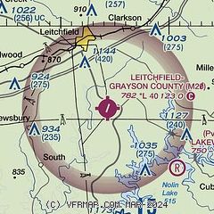
| Sectional chart |
|---|
|
| Airport distance calculator |
|---|
|
|
| Sunrise and sunset |
|---|
|
Times for 28-Jun-2026
| | Local
(UTC-5) | | Zulu
(UTC) |
|---|
| Morning civil twilight | | 04:57 | | 09:57 |
| Sunrise | | 05:28 | | 10:28 |
| Sunset | | 20:09 | | 01:09 |
| Evening civil twilight | | 20:40 | | 01:40 |
|
| Current date and time |
|---|
| Zulu (UTC) | 28-Jun-2026 12:20:35 |
|---|
| Local (UTC-5) | 28-Jun-2026 07:20:35 |
|---|
|
| METAR |
|---|
KGLW
27nm SE | 281155Z AUTO 02004KT 10SM TS BKN014 OVC020 22/22 A2998 RMK AO2 LTG DSNT NW THRU SE 60127 7//// T02220222 10227 20213
|
KBWG
27nm S | 281153Z AUTO 23005KT 10SM OVC055 24/23 A2996 RMK AO2 LTG DSNT NE SLP139 60013 70211 T02440233 10244 20222 53008 $
|
KFTK
32nm NE | 281155Z AUTO 07003KT 7SM VCTS -RA BKN008 OVC020 22/21 A2994 RMK AO2 TSB1055E41 SLP135 P0008 60008 70488 T02150210 10215 20210 53010 $
|
KKY8
44nm NW | 281155Z AUTO 00000KT 4SM BR BKN004 BKN085 OVC110 23/23 A2994 RMK A01 P0049
|
KBRY
44nm NE | 281155Z AUTO 21004KT 6SM -RA BR BKN006 BKN055 BKN085 OVC150 21/21 A2996 RMK AO2 P0000 T02120212 $
|
KM21
44nm W | 281155Z AUTO 00000KT 10SM BKN050 BKN080 25/24 A2995 RMK AO2 60004 70071 T02470244 10247 20230
|
KAAS
45nm E | 281155Z AUTO 00000KT 5SM OVC004 21/21 A3003 RMK AO1
|
KOWB
47nm NW | 281156Z 13004KT 10SM VCTS -RA BKN020 23/23 A2995 RMK AO2 LTG DSNT NE AND E RAB07 SLP140 P0027 60107 7//// T02280228 10233 20222 53013
|
K1M5
50nm S | 281155Z AUTO 23007KT 10SM SCT060 25/24 A2997 RMK A01
|
|
| TAF |
|---|
KBWG
27nm S | 281121Z 2812/2912 21004KT 6SM -SHRA BKN035 TEMPO 2812/2814 3SM -TSRA BKN025CB FM281500 24008KT P6SM BKN050 FM282000 25007KT P6SM FEW050 FM290100 VRB03KT P6SM FEW050 SCT250
|
|
| NOTAMs |
|---|
NOTAMs are issued by the DoD/FAA and will open in a separate window not controlled by AirNav.
|
|

