FAA INFORMATION EFFECTIVE 27 NOVEMBER 2025
Location
| FAA Identifier: | AAS |
| Lat/Long: | 37-21-29.8000N 085-18-33.9000W
37-21.496667N 085-18.565000W
37.3582778,-85.3094167
(estimated) |
| Elevation: | 921 ft. / 280.7 m (surveyed) |
| Variation: | 05W (2015) |
| From city: | 2 miles NE of CAMPBELLSVILLE, KY |
| Time zone: | UTC -5 (UTC -4 during Daylight Saving Time) |
| Zip code: | 42718 |
Airport Operations
| Airport use: | Open to the public |
| Activation date: | 01/1962 |
| Control tower: | no |
| ARTCC: | INDIANAPOLIS CENTER |
| FSS: | LOUISVILLE FLIGHT SERVICE STATION |
| NOTAMs facility: | LOU (NOTAM-D service available) |
| Attendance: | MON-FRI 0800-1700
AFT HR - 270-469-0133/270-789-7770. |
| Wind indicator: | lighted |
| Segmented circle: | yes |
| Lights: | ACVT REIL RWY 05 & 23; PAPI RWY 05 & 23- CTAF; MIRL RWY 05/23 PRESET ON LOW INTST; INCR INTST - CTAF. |
| Beacon: | white-green (lighted land airport)
Operates sunset to sunrise. |
Airport Communications
| CTAF/UNICOM: | 122.7 |
| WX AWOS-3: | 121.125 (270-789-1985) |
| WX AWOS-3P at 6I2 (17 nm N): | 119.725 (859-336-0340) |
- APCH/DEP SVC PRVDD BY INDIANAPOLIS ARTCC ON FREQS 124.625/353.65 (NEW HOPE RCAG).
Nearby radio navigation aids
| VOR radial/distance | | VOR name | | Freq | | Var |
|---|
| EWOr132/24.0 | | NEW HOPE VOR/DME | | 113.95 | | 01E |
| NDB name | | Hdg/Dist | | Freq | | Var | | ID |
|---|
| GOODALL | | 246/29.1 | | 311 | | 03W | | DVK | -.. ...- -.- |
Airport Services
| Fuel available: | 100LL JET-A+
100LL:AVBL AFT HR WITH CREDIT CARD. |
| Parking: | hangars and tiedowns |
| Airframe service: | MINOR |
| Powerplant service: | MINOR |
Runway Information
Runway 5/23
| Dimensions: | 5004 x 75 ft. / 1525 x 23 m |
| Surface: | asphalt, in good condition |
| Weight bearing capacity: | | PCN 14 /F/D/X/T | | Single wheel: | 37.0 | | Double wheel: | 49.0 |
|
| Runway edge lights: | medium intensity |
| Operational restrictions: | TREES BOTH SIDES OF RWY VIOLATE 7:1 TRSNL SFC. |
| RUNWAY 5 | | RUNWAY 23 |
| Latitude: | 37-21.230575N | | 37-21.761555N |
| Longitude: | 085-18.960632W | | 085-18.170453W |
| Elevation: | 871.4 ft. | | 921.0 ft. |
| Traffic pattern: | left | | left |
| Runway heading: | 055 magnetic, 050 true | | 235 magnetic, 230 true |
| Markings: | nonprecision, in fair condition | | nonprecision, in fair condition |
| Visual slope indicator: | 4-light PAPI on left (3.50 degrees glide path) | | 4-light PAPI on left (3.25 degrees glide path) |
| Runway end identifier lights: | yes | | yes |
| Touchdown point: | yes, no lights | | yes, no lights |
| Obstructions: | 53 ft. trees, 788 ft. from runway, 529 ft. right of centerline, 11:1 slope to clear | | 71 ft. trees, 2008 ft. from runway, 745 ft. right of centerline, 25:1 slope to clear |
Airport Ownership and Management from official FAA records
| Ownership: | Publicly-owned |
| Owner: | AIRPORT BOARD
PO BOX 1093
CAMPBELLSVILLE, KY 42719
Phone 270-403-4135
JOHN KERR |
| Manager: | KIRK ANDERSON
360 AIRPORT ROAD
CAMPBELLSVILLE, KY 42718
Phone 270-789-4182 |
Additional Remarks
| - | FOR CD CTC INDIANAPOLIS ARTCC AT 317-247-2411. |
Instrument Procedures
NOTE: All procedures below are presented as PDF files. If you need a reader for these files, you should download the free Adobe Reader.NOT FOR NAVIGATION. Please procure official charts for flight.
FAA instrument procedures published for use from 27 November 2025 at 0901Z to 25 December 2025 at 0900Z.
IAPs - Instrument Approach Procedures |
|---|
| RNAV (GPS) RWY 05 | |
download (253KB) |
| RNAV (GPS) RWY 23 | |
download (269KB) |
| VOR/DME-A | |
download (187KB) |
| NOTE: Special Take-Off Minimums/Departure Procedures apply | |
download (126KB) |
Other nearby airports with instrument procedures:
6I2 - Lebanon Springfield Airport-George Hoerter Field (17 nm N)
K24 - Russell County Airport (23 nm SE)
KBRY - Samuels Field Airport (29 nm N)
KDVK - Stuart Powell Field Airport (29 nm NE)
KEKX - Addington Field Airport (35 nm NW)
|
|

Road maps at:
MapQuest
Bing
Google
| Aerial photo |
|---|
WARNING: Photo may not be current or correct

Do you have a better or more recent aerial photo of Taylor County Airport that you would like to share? If so, please send us your photo.
|
| Sectional chart |
|---|
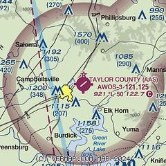
|
| Airport distance calculator |
|---|
|
|
| Sunrise and sunset |
|---|
|
Times for 17-Dec-2025
| | Local
(UTC-5) | | Zulu
(UTC) |
|---|
| Morning civil twilight | | 07:21 | | 12:21 |
| Sunrise | | 07:51 | | 12:51 |
| Sunset | | 17:24 | | 22:24 |
| Evening civil twilight | | 17:53 | | 22:53 |
|
| Current date and time |
|---|
| Zulu (UTC) | 17-Dec-2025 16:24:42 |
|---|
| Local (UTC-5) | 17-Dec-2025 11:24:42 |
|---|
|
| METAR |
|---|
| KAAS | 171555Z AUTO 22009KT 10SM BKN036 09/M01 A3018 RMK AO1
|
K6I2
17nm N | 171555Z AUTO 19013G16KT 10SM CLR 10/M03 A3012 RMK AO2
|
|
| TAF |
|---|
KSME
38nm SE | 171136Z 1712/1812 21008G15KT P6SM OVC050 WS020/24040KT FM171500 22007KT P6SM BKN250
|
KFTK
44nm NW | 171228Z 1712/1818 22009KT 9999 BKN040 QNH3006INS BECMG 1719/1720 19005KT 9999 SCT050 QNH2969INS TX14/1718Z TN07/1712Z
|
|
| NOTAMs |
|---|
NOTAMs are issued by the DoD/FAA and will open in a separate window not controlled by AirNav.
|
|

