FAA INFORMATION EFFECTIVE 09 JULY 2026
Location
| FAA Identifier: | KY8 |
| Lat/Long: | 37-57-15.1530N 086-51-21.5450W
37-57.252550N 086-51.359083W
37.9542092,-86.8559847
(estimated) |
| Elevation: | 411.4 ft. / 125.4 m (surveyed) |
| Variation: | 03W (2010) |
| From city: | 3 miles NE of LEWISPORT, KY |
| Time zone: | UTC -5 (UTC -6 during Standard Time) |
| Zip code: | 42351 |
Airport Operations
| Airport use: | Open to the public |
| Activation date: | 12/2007 |
| Control tower: | no |
| ARTCC: | INDIANAPOLIS CENTER |
| FSS: | LOUISVILLE FLIGHT SERVICE STATION |
| NOTAMs facility: | LOU (NOTAM-D service available) |
| Attendance: | M-F 0700-1200 |
| Wind indicator: | lighted |
| Segmented circle: | yes |
| Lights: | ACTVT REIL RWY 05 & 23; MIRL RWY 5/23 - CTAF. PAPI RWY 05 & 23 OPR CONSLY. |
| Beacon: | white-green (lighted land airport)
Operates sunset to sunrise. |
Airport Communications
| CTAF/UNICOM: | 123.0 |
| WX AWOS-3: | 119.775 (270-295-3565) |
| EVANSVILLE APPROACH: | 124.025 |
| EVANSVILLE DEPARTURE: | 124.025 |
| WX AWOS-3PT at HNB (18 nm N): | 118.250 (812-683-4003) |
| WX AWOS-3PT at OWB (20 nm SW): | 119.025 (270-771-3721) |
- APCH/DEP SVC PRVDD BY INDIANAPOLIS ARTCC ON FREQS 128.3/291.625 (EVANSVILLE RCAG) WHEN EVANSVILLE APCH CTL CLSD.
Nearby radio navigation aids
| VOR radial/distance | | VOR name | | Freq | | Var |
|---|
| OWBr053/19.4 | | OWENSBORO VOR/DME | | 108.65 | | 04W |
| MYSr278/(29.2) | | MYSTIC VOR | | 108.20 | | 01W |
Airport Services
| Fuel available: | 100LL JET-A+
100LL:FUEL AVBL 24/7 WITH CC. |
| Parking: | tiedowns |
Runway Information
Runway 5/23
| Dimensions: | 5002 x 75 ft. / 1525 x 23 m |
| Surface: | asphalt, in good condition |
| Weight bearing capacity: | | Single wheel: | 30.0 | | Double wheel: | 40.0 |
|
| Runway edge lights: | medium intensity |
| RUNWAY 5 | | RUNWAY 23 |
| Latitude: | 37-56.948823N | | 37-57.556262N |
| Longitude: | 086-51.710743W | | 086-51.007368W |
| Elevation: | 409.3 ft. | | 411.3 ft. |
| Traffic pattern: | left | | left |
| Runway heading: | 046 magnetic, 043 true | | 226 magnetic, 223 true |
| Markings: | nonprecision, in fair condition | | nonprecision, in fair condition |
| Visual slope indicator: | 4-light PAPI on left (3.50 degrees glide path) | | 4-light PAPI on left (3.00 degrees glide path) |
| Runway end identifier lights: | yes | | yes |
| Touchdown point: | yes, no lights | | yes, no lights |
| Obstructions: | 104 ft. tree, 2759 ft. from runway, 498 ft. right of centerline, 24:1 slope to clear | | 93 ft. tree, 2104 ft. from runway, 524 ft. left of centerline, 20:1 slope to clear |
Airport Ownership and Management from official FAA records
| Ownership: | Publicly-owned |
| Owner: | HANCOCK COUNTY AIRPORT BOARD
500 AIRPORT ROAD
LEWISPORT, KY 42351
Phone 270-295-4100
TIM POWERS |
| Manager: | BILL BAUGHMAN
500 AIRPORT ROAD
LEWISPORT, KY 42351
Phone 270-302-3262 |
Additional Remarks
| - | FOR CD CTC EVANSVILLE APCH AT 812-436-4690, WHEN APCH CLSD CTC INDIANAPOLIS ARTCC AT 317-247-2411. |
| - | AMGR AVBL BY APNTMT/ PHONE CALL. |
Instrument Procedures
NOTE: All procedures below are presented as PDF files. If you need a reader for these files, you should download the free Adobe Reader.NOT FOR NAVIGATION. Please procure official charts for flight.
FAA instrument procedures published for use from 09 July 2026 at 0901Z to 06 August 2026 at 0900Z.
IAPs - Instrument Approach Procedures |
|---|
| RNAV (GPS) RWY 05 | |
download (201KB) |
| RNAV (GPS) RWY 23 | |
download (212KB) |
| NOTE: Special Alternate Minimums apply | |
download (159KB) |
| NOTE: Special Take-Off Minimums/Departure Procedures apply | |
download (370KB) |
Other nearby airports with instrument procedures:
KTEL - Perry County Municipal Airport (9 nm NE)
KHNB - Huntingburg Airport (18 nm N)
KOWB - Owensboro/Daviess County Regional Airport (20 nm SW)
I93 - Breckinridge County Airport (22 nm SE)
KJQD - Ohio County Airport (30 nm S)
|
|
| Aerial photo |
|---|
WARNING: Photo may not be current or correct
 Photo by Donn Wimmer
Photo taken 02-Jan-2008
Photo by Donn Wimmer
Photo taken 02-Jan-2008
Do you have a better or more recent aerial photo of Hancock County Airport/Ron Lewis Field that you would like to share? If so, please send us your photo.
|
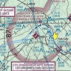
| Sectional chart |
|---|
|
| Airport distance calculator |
|---|
|
|
| Sunrise and sunset |
|---|
|
Times for 15-Jul-2026
| | Local
(UTC-5) | | Zulu
(UTC) |
|---|
| Morning civil twilight | | 05:07 | | 10:07 |
| Sunrise | | 05:38 | | 10:38 |
| Sunset | | 20:09 | | 01:09 |
| Evening civil twilight | | 20:39 | | 01:39 |
|
| Current date and time |
|---|
| Zulu (UTC) | 15-Jul-2026 15:57:06 |
|---|
| Local (UTC-5) | 15-Jul-2026 10:57:06 |
|---|
|
| METAR |
|---|
| KKY8 | 151555Z AUTO 00000KT 10SM FEW027 30/23 A3011 RMK A01
|
KHNB
18nm N | 151456Z AUTO VRB03KT 10SM CLR 28/25 A3013 RMK AO2 SLP197 T02830250 50002
|
|
| TAF |
|---|
KHNB
18nm N | 151120Z 1512/1612 13003KT P6SM SKC TEMPO 1512/1513 4SM BR FM151800 14004KT P6SM SCT050 FM160900 00000KT 4SM BR SKC
|
KOWB
20nm SW | 151120Z 1512/1612 VRB03KT P6SM FEW250 FM151500 13006KT P6SM SCT040 FM160000 VRB02KT P6SM SCT250 TEMPO 1608/1612 6SM BR
|
|
| NOTAMs |
|---|
NOTAMs are issued by the DoD/FAA and will open in a separate window not controlled by AirNav.
|
|

