FAA INFORMATION EFFECTIVE 27 NOVEMBER 2025
Location
| FAA Identifier: | OWB |
| Lat/Long: | 37-44-19.8030N 087-10-00.5828W
37-44.330050N 087-10.009713W
37.7388342,-87.1668286
(estimated) |
| Elevation: | 407.3 ft. / 124.1 m (surveyed) |
| Variation: | 04W (2015) |
| From city: | 3 miles SW of OWENSBORO, KY |
| Time zone: | UTC -6 (UTC -5 during Daylight Saving Time) |
| Zip code: | 42301 |
Airport Operations
| Airport use: | Open to the public |
| Activation date: | 12/1949 |
| Control tower: | yes |
| ARTCC: | INDIANAPOLIS CENTER |
| FSS: | LOUISVILLE FLIGHT SERVICE STATION |
| NOTAMs facility: | OWB (NOTAM-D service available) |
| Attendance: | 0600-2000 |
| Wind indicator: | lighted |
| Segmented circle: | yes |
| Lights: | WHEN ATCT CLSD ACTVT MALSR RWY 36; REIL RWY 06, 18, 24; PAPI RWY 6, 18, 24, 36; MIRL RWY 6/24; HIRL RWY 18/36; TWY; WINDCONE - CTAF. |
| Beacon: | white-green (lighted land airport)
Operates sunset to sunrise. |
| Fire and rescue: | ARFF index B |
| Airline operations: | PPR 24 HR FOR UNSKED ACR OPS WITH MORE THAN 30 PAX - AMGR. |
Airport Communications
| CTAF: | 120.7 |
| UNICOM: | 122.95 |
| WX AWOS-3PT: | 119.025 (270-683-3228) |
| OWENSBORO GROUND: | 121.7 [0600-2200] |
| OWENSBORO TOWER: | 120.7 251.15 [0600-2200] |
| EVANSVILLE APPROACH: | 124.025 |
| EVANSVILLE DEPARTURE: | 124.025 |
| EMERG: | 121.5 243.0 |
| VFR ADZY: | 120.7 251.15 |
| WX AWOS-3 at KY8 (20 nm NE): | 119.775 (270-295-3565) |
- APCH/DEP SVC PRVDD BY INDIANAPOLIS ARTCC ON FREQS 128.3/291.625 (EVANSVILLE RCAG) WHEN EVANSVILLE APCH CTL CLSD.
Nearby radio navigation aids
| VOR radial/distance | | VOR name | | Freq | | Var |
|---|
| OWB at field | | OWENSBORO VOR/DME | | 108.65 | | 04W |
| PXVr109/30.4 | | POCKET CITY VORTAC | | 113.30 | | 03E |
Airport Services
| Fuel available: | 100LL JET-A |
| Parking: | hangars and tiedowns |
| Airframe service: | MAJOR |
| Powerplant service: | MAJOR |
| Bottled oxygen: | LOW |
Runway Information
Runway 18/36
| Dimensions: | 8000 x 150 ft. / 2438 x 46 m |
| Surface: | concrete/grooved, in good condition |
| Weight bearing capacity: | | PCN 37 /R/C/W/T | | Single wheel: | 75.0 | | Double wheel: | 150.0 | | Double tandem: | 200.0 |
|
| Runway edge lights: | high intensity |
| RUNWAY 18 | | RUNWAY 36 |
| Latitude: | 37-44.934935N | | 37-43.617907N |
| Longitude: | 087-10.065968W | | 087-10.000030W |
| Elevation: | 407.3 ft. | | 397.2 ft. |
| Traffic pattern: | left | | left |
| Runway heading: | 182 magnetic, 178 true | | 002 magnetic, 358 true |
| Declared distances: | TORA:8000 TODA:8000 ASDA:8000 LDA:8000 | | TORA:8000 TODA:8000 ASDA:8000 LDA:8000 |
| Markings: | precision, in good condition | | precision, in good condition |
| Visual slope indicator: | 4-light PAPI on left (3.00 degrees glide path) | | 4-light PAPI on left (3.00 degrees glide path) |
| Approach lights: | | | MALSR: 1,400 foot medium intensity approach lighting system with runway alignment indicator lights |
| Runway end identifier lights: | yes | | |
| Touchdown point: | yes, no lights | | yes, no lights |
| Instrument approach: | | | ILS |
Runway 6/24
| Dimensions: | 5000 x 100 ft. / 1524 x 30 m |
| Surface: | asphalt/concrete, in fair condition |
| Weight bearing capacity: | | PCN 17 /R/C/W/T | | Single wheel: | 40.0 | | Double wheel: | 40.0 | | Double tandem: | 40.0 |
|
| Runway edge lights: | medium intensity |
| Operational restrictions: | RWY 06/24 NOT AVBL FOR PART 121/PART 380 OPS WITH SKED PAX CARRYING OPS MORE THAN 9 PAX SEATS AND NON-SKED PAX CARRYING OPS MORE THAN 30 PAX SEATS. |
| RUNWAY 6 | | RUNWAY 24 |
| Latitude: | 37-44.162123N | | 37-44.669633N |
| Longitude: | 087-10.381122W | | 087-09.563812W |
| Elevation: | 405.1 ft. | | 403.1 ft. |
| Traffic pattern: | left | | left |
| Runway heading: | 056 magnetic, 052 true | | 236 magnetic, 232 true |
| Declared distances: | TORA:5000 TODA:5000 ASDA:5000 LDA:5000 | | TORA:5000 TODA:5000 ASDA:5000 LDA:5000 |
| Markings: | nonprecision, in good condition | | nonprecision, in good condition |
| Visual slope indicator: | 2-light PAPI on left (3.00 degrees glide path) | | 2-light PAPI on left (3.00 degrees glide path) |
| Runway end identifier lights: | yes | | yes |
| Touchdown point: | yes, no lights | | yes, no lights |
Airport Ownership and Management from official FAA records
| Ownership: | Publicly-owned |
| Owner: | OWENSBORO CITY & DAVIESS COUNTY
2200 AIRPORT ROAD
OWENSBORO, KY 42303
Phone 270-685-4179 |
| Manager: | TRISTAN DURBIN
2200 AIRPORT ROAD
OWENSBORO, KY 42303
Phone 270-685-4179 |
Additional Remarks
| - | WILDLIFE & AGRICULTURE OPS ON & INVOF ARPT. |
| - | FOR CD WHEN ATCT CLSD CTC EVANSVILLE APCH AT 812-436-4690, WHEN APCH CLSD CTC INDIANAPOLIS ARTCC AT 317-247-2411. |
Instrument Procedures
NOTE: All procedures below are presented as PDF files. If you need a reader for these files, you should download the free Adobe Reader.NOT FOR NAVIGATION. Please procure official charts for flight.
FAA instrument procedures published for use from 27 November 2025 at 0901Z to 25 December 2025 at 0900Z.
IAPs - Instrument Approach Procedures |
|---|
| ILS OR LOC RWY 36 **CHANGED** | |
download (289KB) |
| RNAV (GPS) RWY 06 **CHANGED** | |
download (302KB) |
| RNAV (GPS) RWY 18 **CHANGED** | |
download (307KB) |
| RNAV (GPS) RWY 24 **CHANGED** | |
download (288KB) |
| RNAV (GPS) RWY 36 **CHANGED** | |
download (275KB) |
| VOR RWY 06 **CHANGED** | |
download (273KB) |
| VOR RWY 18 **CHANGED** | |
download (240KB) |
| VOR RWY 36 **CHANGED** | |
download (311KB) |
| NOTE: Special Alternate Minimums apply | |
download (137KB) |
| NOTE: Special Take-Off Minimums/Departure Procedures apply | |
download (363KB) |
Other nearby airports with instrument procedures:
KY8 - Hancock County Airport/Ron Lewis Field (20 nm NE)
KJQD - Ohio County Airport (23 nm SE)
KEVV - Evansville Regional Airport (25 nm NW)
KEHR - Henderson City-County Airport (25 nm W)
2I0 - Madisonville Regional Airport (25 nm SW)
|
|

Road maps at:
MapQuest
Bing
Google
| Aerial photo |
|---|
WARNING: Photo may not be current or correct
 Photo by Eve Cascella
Photo taken 10-Apr-2010
from the south looking north.
Photo by Eve Cascella
Photo taken 10-Apr-2010
from the south looking north.
Do you have a better or more recent aerial photo of Owensboro/Daviess County Regional Airport that you would like to share? If so, please send us your photo.
|
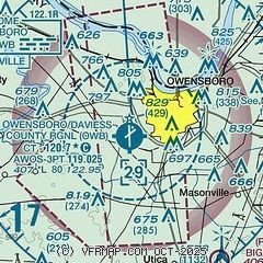
| Sectional chart |
|---|
|
CAUTION: Diagram may not be current
 Download PDF
of official airport diagram from the FAA
| Airport distance calculator |
|---|
|
|
| Sunrise and sunset |
|---|
|
Times for 01-Dec-2025
| | Local
(UTC-6) | | Zulu
(UTC) |
|---|
| Morning civil twilight | | 06:17 | | 12:17 |
| Sunrise | | 06:46 | | 12:46 |
| Sunset | | 16:29 | | 22:29 |
| Evening civil twilight | | 16:58 | | 22:58 |
|
| Current date and time |
|---|
| Zulu (UTC) | 01-Dec-2025 19:13:22 |
|---|
| Local (UTC-6) | 01-Dec-2025 13:13:22 |
|---|
|
| METAR |
|---|
| KOWB | 011856Z 10005KT 10SM FEW085 03/M04 A3021 RMK AO2 SLP234 T00281044
|
KKY8
20nm NE | 011855Z AUTO 07008G14KT 10SM BKN080 03/M04 A3020 RMK A01
|
|
| TAF |
|---|
| KOWB | 011721Z 0118/0218 10009KT P6SM FEW021 FM020000 VRB03KT 6SM -SN OVC020 FM020200 VRB03KT 3SM -SHSN BR OVC006 FM020900 32005KT P6SM BKN008
|
|
| NOTAMs |
|---|
NOTAMs are issued by the DoD/FAA and will open in a separate window not controlled by AirNav.
|
|


