FAA INFORMATION EFFECTIVE 09 JULY 2026
Location
| FAA Identifier: | BTV |
| Lat/Long: | 44-28-19.0380N 073-09-11.7940W
44-28.317300N 073-09.196567W
44.4719550,-73.1532761
(estimated) |
| Elevation: | 334.6 ft. / 102.0 m (surveyed) |
| Variation: | 15W (2005) |
| From city: | 3 miles E of BURLINGTON, VT |
| Time zone: | UTC -4 (UTC -5 during Standard Time) |
| Zip code: | 05403 |
Airport Operations
| Airport use: | Open to the public |
| Activation date: | 09/1937 |
| Control tower: | yes |
| ARTCC: | BOSTON CENTER |
| FSS: | BURLINGTON FLIGHT SERVICE STATION |
| NOTAMs facility: | BTV (NOTAM-D service available) |
| Attendance: | CONTINUOUS |
| Wind indicator: | lighted |
| Segmented circle: | no |
| Lights: | DUSK-DAWN. ACTVT MALSR RWY 15; MALSF RWY 33; PAPI RWY 01 & 15; MIRL RWY 01/19; HIRL RWY 15/33; ALL TWYS - CTAF. PAPI RWY 19 & 33 OPR CONSLY. |
| Beacon: | white-green (lighted land airport)
Operates sunset to sunrise. |
| Landing fee: | yes, FEE FOR ITNRNT ACFT GTR THAN 6000 LBS. |
| Fire and rescue: | ARFF index B |
| International operations: | international airport of entry |
Airport Communications
| CTAF: | 118.3 |
| UNICOM: | 122.95 |
| ATIS: | 123.8 269.9 |
| WX ASOS: | 123.8 (802-657-4490) |
| BURLINGTON GROUND: | 126.3 348.6 [0530-0000] |
| BURLINGTON TOWER: | 118.3 257.8 290.9 388.2 [0530-0000] |
| BURLINGTON APPROACH: | 121.1 278.8 [0530-0000] |
| BURLINGTON DEPARTURE: | 121.1 278.8 [0530-0000] |
| CLEARANCE DELIVERY: | 119.15 |
| ANG OPS: | 293.7 |
| ARNG OPS: | 123.3 134.1 242.4 41.2 |
| CLASS C: | 121.1 278.8 |
| EMERG: | 121.5 243.0 |
| WX ASOS at PBG (17 nm NW): | 132.225 (518-957-5905) |
- APCH/DEP SVC PRVDD BY BOSTON ARTCC ON FREQS 120.35/342.25 (ST. ALBANS RCAG) WHEN BURLINGTON APCH CTL CLSD.
- SAID IN USE. OPERATE TRANSPONDERS WITH ALTITUDE REPORTING MODE AND ADS-B (IF EQUIPPED) ENABLED ON ALL AIRPORT SURFACES.
Nearby radio navigation aids
| VOR radial/distance | | VOR name | | Freq | | Var |
|---|
| BTVr031/4.7 | | BURLINGTON VOR/DME | | 117.50 | | 15W |
| MPVr323/38.1 | | MONTPELIER VOR/DME | | 116.90 | | 16W |
Airport Services
| Fuel available: | 100LL JET-A |
| Parking: | hangars and tiedowns |
| Airframe service: | MAJOR |
| Powerplant service: | MAJOR |
| Bottled oxygen: | HIGH |
| Bulk oxygen: | HIGH |
Runway Information
Runway 15/33
| Dimensions: | 8319 x 150 ft. / 2536 x 46 m |
| Surface: | asphalt/concrete/grooved, in good condition |
| Weight bearing capacity: | | Single wheel: | 100.0 | | Double wheel: | 175.0 | | Double tandem: | 355.0 |
|
| Runway edge lights: | high intensity |
| RUNWAY 15 | | RUNWAY 33 |
| Latitude: | 44-28.840472N | | 44-27.945485N |
| Longitude: | 073-09.952732W | | 073-08.505762W |
| Elevation: | 305.5 ft. | | 334.6 ft. |
| Traffic pattern: | left | | left |
| Runway heading: | 146 magnetic, 131 true | | 326 magnetic, 311 true |
| Displaced threshold: | no | | 500 ft. |
| Declared distances: | TORA:7820 TODA:7820 ASDA:7820 LDA:7820 | | TORA:8320 TODA:8320 ASDA:8320 LDA:7820 |
| Markings: | precision, in good condition | | precision, in good condition |
| Visual slope indicator: | 4-light PAPI on right (3.00 degrees glide path) | | 4-light PAPI on right (3.20 degrees glide path) |
| RVR equipment: | touchdown, rollout | | touchdown, rollout |
| Approach lights: | MALSR: 1,400 foot medium intensity approach lighting system with runway alignment indicator lights | | MALSF: 1,400 foot medium intensity approach lighting system with sequenced flashers |
| Runway end identifier lights: | | | no |
| Touchdown point: | yes, no lights | | yes, no lights |
| Instrument approach: | ILS/DME | | ILS/DME |
| Obstructions: | 51 ft. trees, 1930 ft. from runway, 705 ft. right of centerline, 33:1 slope to clear | | 75 ft. trees, 1975 ft. from runway, 800 ft. left of centerline, 23:1 slope to clear
30:1 TO DTHR. |
Runway 1/19
| Dimensions: | 4112 x 75 ft. / 1253 x 23 m |
| Surface: | asphalt, in good condition |
| Weight bearing capacity: | | Single wheel: | 30.0, SOUTH OF RWY 15/33 INTXN TO TWY C, SW 100 DTW 355; SOUTH OF TWY C INTXN TO SOUTH END OF RWY, SW 30 DW 60. | | Double wheel: | 40.0 | | Double tandem: | 60.0 |
|
| Runway edge lights: | medium intensity |
| RUNWAY 1 | | RUNWAY 19 |
| Latitude: | 44-27.829552N | | 44-28.498680N |
| Longitude: | 073-09.060185W | | 073-09.201128W |
| Elevation: | 333.7 ft. | | 326.8 ft. |
| Traffic pattern: | left | | left |
| Runway heading: | 006 magnetic, 351 true | | 186 magnetic, 171 true |
| Displaced threshold: | 225 ft. | | 500 ft. |
| Declared distances: | TORA:3611 TODA:3611 ASDA:3611 LDA:3386 | | TORA:4111 TODA:4111 ASDA:4111 LDA:3386 |
| Markings: | nonprecision, in good condition | | basic, in good condition |
| Visual slope indicator: | 4-light PAPI on left (4.00 degrees glide path) | | 4-light PAPI on right (3.50 degrees glide path) |
| Touchdown point: | yes, no lights | | yes, no lights |
| Obstructions: | 63 ft. tree, 1290 ft. from runway, 25 ft. left of centerline, 17:1 slope to clear
20:1 TO DTHR. | | none |
Airport Ownership and Management from official FAA records
| Ownership: | Publicly-owned |
| Owner: | CITY OF BURLINGTON
CITY HALL
BURLINGTON, VT 05401
Phone 802-865-7272 |
| Manager: | NICOLAS LONGO
1200 ARPT DR NO 1
SOUTH BURLINGTON, VT 05403
Phone 802-863-2874 |
Additional Remarks
| A39-01/19 | PCR VALUE: 700/F/C/X/T |
| A39-15/33 | PCR VALUE: 751/R/C/W/T |
| E60-33 | TYPE H/BAK-12A (B) 1500 FT. |
| E60-15 | TYPE H/BAK-12A (B) 1499 FT. |
| - | CTN: GENERATING PLANT 2 NM FROM AER 15 PRODUCES STEAM WHICH MAY OBSC VSBTY ON FNA. |
| - | TWY L CLSD TO ACFT OVR 60000 LBS. |
| - | ANG: NON-STD TWY LGTS ON TWY E. |
| - | TWYS D, E, F, N CLSD TO CIVILIAN OPS. |
| - | SERVICE-A-GEAR: TYPE H/BAK-12A(B) AER 33 LCTD 1000 FT FM DTHR. TYPE H/BAK 12A(B) CABLE RAISED BY TWR ON PILOT REQ ONLY. RWY 15 & RWY 33 A-G HOUSINGS ARE NON-FRANGIBLE (26 IN ABV GRD LEVEL) LCTD 250 FT FM RWY CNTLN. |
| - | ACR RAMP NOT AVBL FOR PVT & CHTR ACFT. |
| - | ANG: OPR 1030-2100Z++ WKDAYS, EXC HOL, CLSD SAT-MON. PPR FOR FUEL/PRKG, CTC ANG OPS DSN 220-5213/5920/5267 C802-660-5213. ALL TSNT ACFT ENR ETHAN ALLEN TRNG SITE AND R-6501A MUST STOP AT AASF FOR RQRD SAFETY BRIEF. |
| - | TWY M AVBL FOR SEASONAL USE, CLSD DRG WINTER MONTHS. |
| - | FIGHTER ACFT: NO LOW APCHS. ALL OTHER MIL ACFT LTD TO TWO PRACTICE APCHS. DO NOT FLY OVER HOSPITAL APRXLY 1.5 NM WEST OF RWY 15 APCH END. |
| - | TWY A BTN TWY G & TWY C CLSD TO ACFT WINGSPAN MORE THAN 118 FT EXC 1 HR PPR 802-316-6014 DLY. |
| - | FBO CLSD 0200-0900 DLY, EXC 1 HR PPR 802-863-3626. |
| - | COLD TEMPERATURE AIRPORT. ALTITUDE CORRECTION REQUIRED AT OR BELOW -9C. |
| - | BIRDS & DEER ON & INVOF ARPT. |
| - | ARFF AVBL 24 HRS. |
| - | CAUTION: PHASE II WILDLIFE ACTVY DURG MIGRATION, MAR-MAY & AUG15-NOV15. |
| - | FOR CD IF TWR CLSD & UNA TO CTC FSS FREQ, CTC BOSTON ARTCC AT 603-879-6859. |
| - | BETA HELIPAD PVT USE ONLY. |
| - | TWY G BTWN J & VALLEY RAMP CLSD TO ACFT WINGSPAN GTR THAN 156 FT. |
| - | TWY K CLSD TO ACFT WINGSPAN MORE THAN 49 FT AND ACFT MORE THAN 12500 LB. |
| - | TWYS D, E, F, N, ANG & RNG RAMPS HAVE UNCONTROLLED VEHICLES & ACFT. |
| - | FIGHTER ACFT RSTRD TO TKOF WINDOW OF 0830-2230 MON-SAT; 1200-2230 SUN. |
Instrument Procedures
NOTE: All procedures below are presented as PDF files. If you need a reader for these files, you should download the free Adobe Reader.NOT FOR NAVIGATION. Please procure official charts for flight.
FAA instrument procedures published for use from 09 July 2026 at 0901Z to 06 August 2026 at 0900Z.
IAPs - Instrument Approach Procedures |
|---|
| ILS OR LOC RWY 15 | |
download (362KB) |
| ILS OR LOC RWY 33 | |
download (442KB) |
| RNAV (GPS) RWY 01 | |
download (329KB) |
| RNAV (GPS) RWY 15 | |
download (307KB) |
| RNAV (GPS) Y RWY 33 | |
download (430KB) |
| RNAV (GPS) Z RWY 33 | |
download (389KB) |
| VOR RWY 01 | |
download (256KB) |
| HI-TACAN RWY 15 | |
download (133KB) |
| HI-TACAN RWY 33 | |
download (158KB) |
| NOTE: Special Alternate Minimums apply | |
download (150KB) |
Departure Procedures |
|---|
| BURLINGTON ONE | |
download (161KB) |
| NOTE: Special Take-Off Minimums/Departure Procedures apply | |
download (512KB) |
Other nearby airports with instrument procedures:
KPBG - Plattsburgh International Airport (17 nm NW)
KMVL - Morrisville-Stowe State Airport (23 nm E)
KFSO - Franklin County State Airport (28 nm N)
KMPV - Edward F Knapp State Airport (30 nm SE)
KLKP - Lake Placid Airport (37 nm W)
|
|

Road maps at:
MapQuest
Bing
Google
| Aerial photo |
|---|
WARNING: Photo may not be current or correct
 Photo by Pete Chaisson- Portland Flight Service
Photo taken 09-Sep-2014
looking west
Photo by Pete Chaisson- Portland Flight Service
Photo taken 09-Sep-2014
looking west
Do you have a better or more recent aerial photo of Patrick Leahy Burlington International Airport that you would like to share? If so, please send us your photo.
|
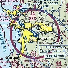
| Sectional chart |
|---|
|
CAUTION: Diagram may not be current
 Download PDF
of official airport diagram from the FAA
| Airport distance calculator |
|---|
|
|
| Sunrise and sunset |
|---|
|
Times for 25-Jul-2026
| | Local
(UTC-4) | | Zulu
(UTC) |
|---|
| Morning civil twilight | | 04:59 | | 08:59 |
| Sunrise | | 05:33 | | 09:33 |
| Sunset | | 20:25 | | 00:25 |
| Evening civil twilight | | 21:00 | | 01:00 |
|
| Current date and time |
|---|
| Zulu (UTC) | 26-Jul-2026 02:23:48 |
|---|
| Local (UTC-4) | 25-Jul-2026 22:23:48 |
|---|
|
| METAR |
|---|
| KBTV | 260154Z 12006KT 10SM BKN080 23/14 A2996 RMK AO2 SLP143 T02280144
|
KPBG
17nm NW | 260153Z AUTO 00000KT 10SM BKN080 21/16 A2994 RMK AO2 SLP139 T02060156 $
|
|
| TAF |
|---|
| KBTV | 251720Z 2518/2618 19008KT P6SM SKC FM260100 VRB03KT P6SM SKC FM261300 18007KT P6SM SCT150
|
KPBG
17nm NW | 251720Z 2518/2618 14011KT P6SM SKC FM260000 00000KT P6SM SKC FM261300 14009KT P6SM SKC
|
|
| NOTAMs |
|---|
NOTAMs are issued by the DoD/FAA and will open in a separate window not controlled by AirNav.
|
|


