FAA INFORMATION EFFECTIVE 18 APRIL 2024
Location
| FAA Identifier: | C44 |
| Lat/Long: | 41-57-20.5000N 072-03-15.7000W
41-57.341667N 072-03.261667W
41.9556944,-72.0543611
(estimated) |
| Elevation: | 770 ft. / 235 m (estimated) |
| Variation: | 15W (1985) |
| From city: | 6 miles NW of PUTNAM, CT |
| Time zone: | UTC -4 (UTC -5 during Standard Time) |
| Zip code: | 06282 |
Airport Operations
| Airport use: | Open to the public |
| Activation date: | 01/1971 |
| Control tower: | no |
| ARTCC: | BOSTON CENTER |
| FSS: | BRIDGEPORT FLIGHT SERVICE STATION |
| NOTAMs facility: | BDR (NOTAM-D service available) |
| Attendance: | IREG |
| Wind indicator: | yes |
| Segmented circle: | no |
Airport Communications
| CTAF: | 122.9 |
| WX AWOS-3 at LZD (11 nm SE): | 119.125 (860-779-7251) |
| WX ASOS at IJD (14 nm SW): | 133.675 (860-456-8839) |
Nearby radio navigation aids
| VOR radial/distance | | VOR name | | Freq | | Var |
|---|
| PUTr284/9.4 | | PUTNAM VOR/DME | | 117.40 | | 14W |
| ORWr008/24.1 | | NORWICH VOR/DME | | 110.00 | | 14W |
| HFDr062/29.0 | | HARTFORD VOR/DME | | 114.90 | | 13W |
| PVDr310/31.2 | | PROVIDENCE VOR/DME | | 115.60 | | 14W |
| BAFr127/32.0 | | BARNES VORTAC | | 113.00 | | 14W |
| GDMr194/35.4 | | GARDNER VOR/DME | | 116.95 | | 14W |
| GONr014/37.5 | | GROTON VOR/DME | | 110.85 | | 14W |
Airport Services
| Parking: | tiedowns |
| Airframe service: | NONE |
| Powerplant service: | NONE |
Runway Information
Runway 17/35
| Dimensions: | 1756 x 60 ft. / 535 x 18 m |
| Surface: | asphalt, in good condition |
| Operational restrictions: | NOT PLOWED; NO SKI OPNS. |
| RUNWAY 17 | | RUNWAY 35 |
| Latitude: | 41-57.467930N | | 41-57.216732N |
| Longitude: | 072-03.356710W | | 072-03.164962W |
| Elevation: | 771.5 ft. | | 756.1 ft. |
| Traffic pattern: | left | | left |
| Markings: | basic, in good condition | | basic, in good condition |
| Obstructions: | 70 ft. trees, 201 ft. from runway, 120 ft. left of centerline, 1:1 slope to clear
70 FT TREES, 0-199 FT DSTC, 113 R; 10 FT PLINE, 0-199 FT DSTC, 113 L. | | 42 ft. trees, 263 ft. from runway, 22 ft. right of centerline, 1:1 slope to clear
25 FT TREE, 100 FT DSTC, 94 FT L. |
Airport Ownership and Management from official FAA records
| Ownership: | Privately-owned |
| Owner: | ROLAND J. TOUTANT
80 BUNGAY HILL ROAD
WEST WOODSTOCK, CT 06281
Phone 860-974-2099 |
| Manager: | ROLAND J. TOUTANT
80 BUNGAY HILL ROAD
WEST WOODSTOCK, CT 06281
Phone 860-974-2099 |
Airport Operational Statistics
| Aircraft based on the field: | | 4 | | Single engine airplanes: | | 1 | | Helicopters: | | 2 | | Ultralights: | | 1 |
| |  | |
| Aircraft operations: 200/year * | | 60% | transient general aviation | | 40% | local general aviation | | * for 12-month period ending 15 July 2023 | |
Additional Remarks
| - | ACFT BACK TAXI ON RWY. |
| - | FOR CD CTC YANKEE APCH AT 860-386-3597 |
| - | 40 FT DROP OFF AT EACH RWY END. |
| - | ARPT CLSD SS-SR, NO LIGHTS. |
Instrument Procedures
There are no published instrument procedures at C44.
Some nearby airports with instrument procedures:
3B0 - Southbridge Municipal Airport (9 nm N)
KLZD - Danielson Airport (11 nm SE)
KIJD - Windham Airport (14 nm SW)
KORH - Worcester Regional Airport (20 nm NE)
KSFZ - North Central State Airport (25 nm E)
|
|

Road maps at:
MapQuest
Bing
Google
| Aerial photo |
|---|
WARNING: Photo may not be current or correct
 Photo by Graeme J W Smith
Photo taken 06-Nov-2011
looking north.
Photo by Graeme J W Smith
Photo taken 06-Nov-2011
looking north.
Do you have a better or more recent aerial photo of Toutant Airport that you would like to share? If so, please send us your photo.
|
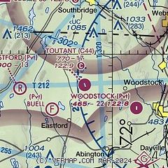
| Sectional chart |
|---|
|
| Airport distance calculator |
|---|
|
|
| Sunrise and sunset |
|---|
|
Times for 25-Apr-2024
| | Local
(UTC-4) | | Zulu
(UTC) |
|---|
| Morning civil twilight | | 05:22 | | 09:22 |
| Sunrise | | 05:52 | | 09:52 |
| Sunset | | 19:40 | | 23:40 |
| Evening civil twilight | | 20:10 | | 00:10 |
|
| Current date and time |
|---|
| Zulu (UTC) | 25-Apr-2024 13:54:18 |
|---|
| Local (UTC-4) | 25-Apr-2024 09:54:18 |
|---|
|
| METAR |
|---|
KIJD
14nm SW | 251252Z AUTO 03004KT 10SM CLR 04/M07 A3035 RMK AO2 SLP279 T00441072
|
KORH
20nm NE | 251254Z 06005KT 10SM CLR 03/M12 A3030 RMK AO2 SLP271 T00281117
|
KSFZ
25nm E | 251256Z AUTO 03009KT 10SM CLR 04/M09 A3034 RMK AO2 SLP278 T00391094 $
|
KCEF
25nm NW | 251255Z 35010KT 10SM FEW120 05/M11 A3033 RMK AO2A SLP279 T00511107
|
|
| TAF |
|---|
KORH
20nm NE | 251120Z 2512/2612 01007KT P6SM SKC FM251500 35004KT P6SM SKC FM251900 30006KT P6SM SKC FM260900 36007KT P6SM SKC
|
KCEF
25nm NW | 251200Z 2512/2618 04009KT 9999 FEW100 FEW200 510153 QNH3028INS TEMPO 2512/2516 01010G20KT 510005 TEMPO 2516/2522 31010G20KT 510005 BECMG 2521/2522 32009KT 9999 FEW250 QNH3024INS WND VRB06KT AFT 2602 TX16/2520Z TNM04/2609Z
|
|
| NOTAMs |
|---|
NOTAMs are issued by the DoD/FAA and will open in a separate window not controlled by AirNav.
|
|

