FAA INFORMATION EFFECTIVE 30 OCTOBER 2025
Location
| FAA Identifier: | CDS |
| Lat/Long: | 34-26-01.6000N 100-17-16.8000W
34-26.026667N 100-17.280000W
34.4337778,-100.2880000
(estimated) |
| Elevation: | 1953.8 ft. / 595.5 m (surveyed) |
| Variation: | 06E (2010) |
| From city: | 4 miles W of CHILDRESS, TX |
| Time zone: | UTC -6 (UTC -5 during Daylight Saving Time) |
| Zip code: | 79201 |
Airport Operations
| Airport use: | Open to the public |
| Activation date: | 07/1943 |
| Control tower: | no |
| ARTCC: | FORT WORTH CENTER |
| FSS: | FORT WORTH FLIGHT SERVICE STATION |
| NOTAMs facility: | CDS (NOTAM-D service available) |
| Attendance: | 0800-1600 |
| Wind indicator: | lighted |
| Segmented circle: | yes |
| Lights: | MIRL RWY 18/36 PRESET LOW INTST; TO INCR INTST ACTVT - CTAF. |
| Beacon: | white-green (lighted land airport)
Operates sunset to sunrise. |
Airport Communications
| CTAF/UNICOM: | 122.8 |
| WX ASOS: | 135.125 (940-937-6337) |
- APCH/DEP CTL SVC PRVDD BY FORT WORTH ARTCC (ZFW) ON FREQS 133.5/350.35 (PADUCAH RCAG).
Nearby radio navigation aids
| VOR radial/distance | | VOR name | | Freq | | Var |
|---|
| CDSr351/3.9 | | CHILDRESS VORTAC | | 117.00 | | 10E |
Airport Services
| Fuel available: | 100LL JET-A1+
100LL:24 HR SELF SVC 100LL AND JET A+. FULL SVC JET A+ AVBL DURG OPRG HRS; AFT HRS CALL 940-937-8309. |
| Parking: | tiedowns |
Runway Information
Runway 18/36
| Dimensions: | 5949 x 75 ft. / 1813 x 23 m |
| Surface: | asphalt, in good condition |
| Weight bearing capacity: | |
| Runway edge lights: | medium intensity
NSTD MIRL RWY 36 THLD LGTS 60 FT SOUTH OF RWY END. |
| RUNWAY 18 | | RUNWAY 36 |
| Latitude: | 34-26.415758N | | 34-25.435542N |
| Longitude: | 100-17.131762W | | 100-17.170350W |
| Elevation: | 1948.8 ft. | | 1953.8 ft. |
| Traffic pattern: | left | | left |
| Runway heading: | 176 magnetic, 182 true | | 356 magnetic, 002 true |
| Markings: | nonprecision, in fair condition | | nonprecision, in fair condition |
| Visual slope indicator: | 2-light PAPI on left (3.00 degrees glide path) | | 2-light PAPI on left (3.00 degrees glide path) |
| Touchdown point: | yes, no lights | | yes, no lights |
| Obstructions: | 25 ft. pole, 1090 ft. from runway, 396 ft. left of centerline, 35:1 slope to clear | | none |
Runway 4/22
| Dimensions: | 4425 x 60 ft. / 1349 x 18 m |
| Surface: | asphalt, in poor condition
RWY NOT MNTND; LOOSE GRAVEL AND VEGETATION GROWING THROUGH THE PAVEMENT. |
| Weight bearing capacity: | |
| Operational restrictions: | CLSD INDEFLY. |
| RUNWAY 4 | | RUNWAY 22 |
| Latitude: | 34-25.913618N | | 34-26.412118N |
| Longitude: | 100-17.773595W | | 100-17.130752W |
| Elevation: | 1941.6 ft. | | 1949.0 ft. |
| Traffic pattern: | left | | left |
| Runway heading: | 041 magnetic, 047 true | | 221 magnetic, 227 true |
| Markings: | basic, in poor condition | | basic, in poor condition |
| Touchdown point: | yes, no lights | | yes, no lights |
Airport Ownership and Management from official FAA records
| Ownership: | Publicly-owned |
| Owner: | CITY OF CHILDRESS
315 COMMERCE STREET
CHILDRESS, TX 79201
Phone 940-937-3684 |
| Manager: | TIFFANY TULLY
15716 FM 164
CHILDRESS, TX 79201
Phone 940-937-8309 |
Additional Remarks
| - | SOME TWYS ROUGH DUE TO GRASS & WEED ENCROACHMENT. |
| - | AGRICULTURE OPNS NEAR ALL PAVED SFCS. |
| - | FOR CD CTC FORT WORTH ARTCC AT 817-858-7584. |
| - | RWY 18/36, NMRS LGTS MISG, OUT, INCOR COLOR OR ORIENTATION. |
Instrument Procedures
NOTE: All procedures below are presented as PDF files. If you need a reader for these files, you should download the free Adobe Reader.NOT FOR NAVIGATION. Please procure official charts for flight.
FAA instrument procedures published for use from 30 October 2025 at 0901Z to 27 November 2025 at 0900Z.
IAPs - Instrument Approach Procedures |
|---|
| RNAV (GPS) RWY 36 | |
download (264KB) |
| VOR RWY 36 | |
download (195KB) |
| NOTE: Special Alternate Minimums apply | |
download (117KB) |
| NOTE: Special Take-Off Minimums/Departure Procedures apply | |
download (113KB) |
Other nearby airports with instrument procedures:
3F6 - Dan E Richards Municipal Airport (24 nm S)
O35 - Hollis Municipal Airport (25 nm NE)
2K4 - Scott Field Airport (47 nm NE)
KAXS - Altus/Quartz Mountain Regional Airport (50 nm E)
F05 - Wilbarger County Airport (51 nm E)
|
|

Road maps at:
MapQuest
Bing
Google
| Aerial photo |
|---|
WARNING: Photo may not be current or correct
 Photo from a 1941 Fleet Model 16B owned by the Texas Air and Space Museum
Photo taken 20-Apr-2020
looking northwest.
Photo from a 1941 Fleet Model 16B owned by the Texas Air and Space Museum
Photo taken 20-Apr-2020
looking northwest.
Do you have a better or more recent aerial photo of Childress Municipal Airport that you would like to share? If so, please send us your photo.
|
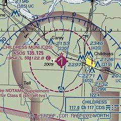
| Sectional chart |
|---|
|
CAUTION: Diagram may not be current

| Airport distance calculator |
|---|
|
|
| Sunrise and sunset |
|---|
|
Times for 02-Nov-2025
| | Local
(UTC-6) | | Zulu
(UTC) |
|---|
| Morning civil twilight | | 06:37 | | 12:37 |
| Sunrise | | 07:03 | | 13:03 |
| Sunset | | 17:46 | | 23:46 |
| Evening civil twilight | | 18:12 | | 00:12 |
|
| Current date and time |
|---|
| Zulu (UTC) | 03-Nov-2025 00:08:29 |
|---|
| Local (UTC-6) | 02-Nov-2025 18:08:29 |
|---|
|
| METAR |
|---|
| KCDS | 022353Z AUTO 17008KT 10SM CLR 21/02 A3009 RMK AO2 SLP181 T02110017 10261 20200 55002
|
|
| TAF |
|---|
| KCDS | 021720Z 0218/0318 21013KT P6SM SKC FM022300 18010KT P6SM SKC
|
|
| NOTAMs |
|---|
NOTAMs are issued by the DoD/FAA and will open in a separate window not controlled by AirNav.
|
|


