FAA INFORMATION EFFECTIVE 27 NOVEMBER 2025
Location
| FAA Identifier: | F05 |
| Lat/Long: | 34-13-32.4000N 099-17-01.5000W
34-13.540000N 099-17.025000W
34.2256667,-99.2837500
(estimated) |
| Elevation: | 1264.7 ft. / 385.5 m (surveyed) |
| Variation: | 08E (1980) |
| From city: | 4 miles N of VERNON, TX |
| Time zone: | UTC -6 (UTC -5 during Daylight Saving Time) |
| Zip code: | 76384 |
Airport Operations
| Airport use: | Open to the public |
| Activation date: | 02/1947 |
| Control tower: | no |
| ARTCC: | FORT WORTH CENTER |
| FSS: | FORT WORTH FLIGHT SERVICE STATION |
| NOTAMs facility: | F05 (NOTAM-D service available) |
| Attendance: | MON-SAT 0800-1700 |
| Wind indicator: | lighted |
| Segmented circle: | yes |
| Lights: | MIRLS DUSK-DAWN. |
| Beacon: | white-green (lighted land airport)
Operates sunset to sunrise. |
Airport Communications
| CTAF/UNICOM: | 122.8 |
| WX AWOS-3: | 118.525 (940-552-8600) |
| ALTUS APPROACH: | 125.1 |
| ALTUS DEPARTURE: | 125.1 |
| WX ASOS at FDR (17 nm NE): | 132.675 (580-335-7591) |
- APCH/DEP SVC PRVDD BY FORT WORTH ARTCC (ZFW) ON FREQS 128.4/269.375 (CLINTONSHERMAN RCAG) & 133.5/350.35 (WICHITA FALLS RCAG) WHEN ALTUS APCH CLSD.
Nearby radio navigation aids
| VOR radial/distance | | VOR name | | Freq | | Var |
|---|
| LTSr176/26.2 | | ALTUS VORTAC | | 109.80 | | 05E |
| SPSr283/37.2 | | WICHITA FALLS VORTAC | | 112.70 | | 10E |
| HBRr186/40.0 | | HOBART VORTAC | | 115.85 | | 10E |
Airport Services
| Fuel available: | 100LL JET-A+
100LL:100 LL SELF-SERVE. 100LL, JET A+ FULL SERVE; AFT HRS SVC CALL 940-839-6365. |
| Parking: | hangars and tiedowns |
| Bottled oxygen: | NONE |
| Bulk oxygen: | NONE |
Runway Information
Runway 2/20
| Dimensions: | 5099 x 100 ft. / 1554 x 30 m |
| Surface: | asphalt, in excellent condition |
| Weight bearing capacity: | | Single wheel: | 30.0 | | Double wheel: | 40.0 | | Double tandem: | 60.0 |
|
| Runway edge lights: | medium intensity |
| RUNWAY 2 | | RUNWAY 20 |
| Latitude: | 34-13.189595N | | 34-13.903295N |
| Longitude: | 099-17.266658W | | 099-16.731912W |
| Elevation: | 1264.4 ft. | | 1255.3 ft. |
| Traffic pattern: | left | | left |
| Runway heading: | 024 magnetic, 032 true | | 204 magnetic, 212 true |
| Markings: | nonprecision, in good condition | | nonprecision, in good condition |
| Visual slope indicator: | | | 4-box VASI on left (3.00 degrees glide path) |
| Touchdown point: | yes, no lights | | yes, no lights |
| Obstructions: | 15 ft. road, 710 ft. from runway, 295 ft. right of centerline, 34:1 slope to clear | | 10 ft. road, 617 ft. from runway, 317 ft. left of centerline, 41:1 slope to clear |
Runway 16/34
| Dimensions: | 4304 x 80 ft. / 1312 x 24 m |
| Surface: | asphalt, in fair condition |
| Weight bearing capacity: | |
| Runway edge lights: | medium intensity |
| RUNWAY 16 | | RUNWAY 34 |
| Latitude: | 34-13.877820N | | 34-13.190130N |
| Longitude: | 099-17.159010W | | 099-16.948450W |
| Elevation: | 1258.3 ft. | | 1259.2 ft. |
| Traffic pattern: | left | | left |
| Runway heading: | 158 magnetic, 166 true | | 338 magnetic, 346 true |
| Markings: | nonprecision, in good condition | | nonprecision, in good condition |
| Touchdown point: | yes, no lights | | yes, no lights |
| Obstructions: | 12 ft. road, 432 ft. from runway, 19:1 slope to clear | | none |
Airport Ownership and Management from official FAA records
| Ownership: | Publicly-owned |
| Owner: | WILBARGER COUNTY
COUNTY COURTHOUSE, 1700 WILBARGER ST
VERNON, TX 76384
Phone 940-553-2300 |
| Manager: | KYLE MILLER
12557 HAMP NAYLOR DRIVE
VERNON, TX 76384
Phone 940-552-2182 |
Additional Remarks
| - | SEASONAL EXTSV AERIAL AG OPS. |
| - | FOR CD CTC FORT WORTH ARTCC AT 817-858-7584. |
| - | RWY 2/20 GRASS ENCROACHING 13 FT EACH SIDE |
Instrument Procedures
NOTE: All procedures below are presented as PDF files. If you need a reader for these files, you should download the free Adobe Reader.NOT FOR NAVIGATION. Please procure official charts for flight.
FAA instrument procedures published for use from 27 November 2025 at 0901Z to 25 December 2025 at 0900Z.
IAPs - Instrument Approach Procedures |
|---|
| RNAV (GPS) RWY 02 | |
download (196KB) |
| RNAV (GPS) RWY 20 | |
download (214KB) |
| NOTE: Special Alternate Minimums apply | |
download (16KB) |
| NOTE: Special Take-Off Minimums/Departure Procedures apply | |
download (113KB) |
Other nearby airports with instrument procedures:
KFDR - Frederick Regional Airport (17 nm NE)
KLTS - Altus Air Force Base (27 nm N)
KAXS - Altus/Quartz Mountain Regional Airport (29 nm N)
60F - Seymour Municipal Airport (35 nm S)
F14 - Wichita Valley Airport (37 nm SE)
|
|

Road maps at:
MapQuest
Bing
Google
| Aerial photo |
|---|
WARNING: Photo may not be current or correct
 Photo by Mike Evans
Photo taken 22-Jan-2013
looking north.
Photo by Mike Evans
Photo taken 22-Jan-2013
looking north.
Do you have a better or more recent aerial photo of Wilbarger County Airport that you would like to share? If so, please send us your photo.
|
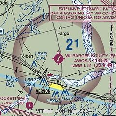
| Sectional chart |
|---|
|
| Airport distance calculator |
|---|
|
|
| Sunrise and sunset |
|---|
|
Times for 21-Dec-2025
| | Local
(UTC-6) | | Zulu
(UTC) |
|---|
| Morning civil twilight | | 07:12 | | 13:12 |
| Sunrise | | 07:40 | | 13:40 |
| Sunset | | 17:30 | | 23:30 |
| Evening civil twilight | | 17:58 | | 23:58 |
|
| Current date and time |
|---|
| Zulu (UTC) | 21-Dec-2025 12:05:33 |
|---|
| Local (UTC-6) | 21-Dec-2025 06:05:33 |
|---|
|
| METAR |
|---|
| KF05 | 211155Z AUTO 36006KT 10SM CLR 03/M02 A3023 RMK AO2 T00341025 10067 20033
|
KFDR
17nm NE | 211153Z AUTO 01009KT 10SM CLR 03/M03 A3017 RMK AO2 SLP217 T00281028 10056 20028 50010
|
|
| NOTAMs |
|---|
NOTAMs are issued by the DoD/FAA and will open in a separate window not controlled by AirNav.
|
|


