FAA INFORMATION EFFECTIVE 30 OCTOBER 2025
Location
| FAA Identifier: | FDR |
| Lat/Long: | 34-21-07.5449N 098-59-02.0727W
34-21.125748N 098-59.034545W
34.3520958,-98.9839091
(estimated) |
| Elevation: | 1258 ft. / 383.4 m (surveyed) |
| Variation: | 07E (2000) |
| From city: | 3 miles SE of FREDERICK, OK |
| Time zone: | UTC -6 (UTC -5 during Daylight Saving Time) |
| Zip code: | 73542 |
Airport Operations
| Airport use: | Open to the public |
| Activation date: | 07/1943 |
| Control tower: | no |
| ARTCC: | FORT WORTH CENTER |
| FSS: | MC ALESTER FLIGHT SERVICE STATION |
| NOTAMs facility: | FDR (NOTAM-D service available) |
| Attendance: | MON-SAT 0800-1700, ALL SUN 1300-1700 |
| Wind indicator: | lighted |
| Segmented circle: | yes |
| Lights: | ACTVT MIRL RWY 17/35 - CTAF. PAPI RWY 17 & 35 ON CONSLY. |
| Beacon: | white-green (lighted land airport)
Operates sunset to sunrise. |
Airport Communications
| CTAF/UNICOM: | 123.05 |
| WX ASOS: | 132.675 (580-335-7591) |
| ALTUS APPROACH: | 125.1 |
| ALTUS DEPARTURE: | 125.1 |
| WX AWOS-3 at F05 (17 nm SW): | 118.525 (940-552-8600) |
- ADVISORY SVC PRVDD TO CIVIL ACFT WHEN MILITARY USING ARPT FOR TRAINING.
- APCH/DEP SVC PRVDD BY FORT WORTH ARTCC (ZFW) ON FREQS 128.4/269.375 (CLINTON-SHERMAN RCAG) & 133.5/350.35 (WICHITA FALLS RCAG) WHEN ALTUS APCH CLSD.
Nearby radio navigation aids
| VOR radial/distance | | VOR name | | Freq | | Var |
|---|
| LTSr138/23.4 | | ALTUS VORTAC | | 109.80 | | 05E |
| SPSr308/29.2 | | WICHITA FALLS VORTAC | | 112.70 | | 10E |
| LAWr244/29.5 | | LAWTON VOR/DME | | 116.85 | | 09E |
| HBRr163/31.1 | | HOBART VORTAC | | 115.85 | | 10E |
Airport Services
| Fuel available: | 100LL
100LL:SELF SER FUEL AVBL 24 HRS, FOR ASSISTANCE CALL 580-335-1948. |
| Parking: | tiedowns |
| Airframe service: | NONE |
| Powerplant service: | NONE |
| Bottled oxygen: | NONE |
| Bulk oxygen: | NONE |
Runway Information
Runway 17/35
| Dimensions: | 6099 x 150 ft. / 1859 x 46 m |
| Surface: | asphalt, in good condition |
| Weight bearing capacity: | | Single wheel: | 35.0 | | Double wheel: | 50.0 | | Double tandem: | 100.0 |
|
| Runway edge lights: | medium intensity |
| RUNWAY 17 | | RUNWAY 35 |
| Latitude: | 34-21.633283N | | 34-20.627845N |
| Longitude: | 098-59.360177W | | 098-59.361093W |
| Elevation: | 1254.3 ft. | | 1236.1 ft. |
| Traffic pattern: | left | | left |
| Runway heading: | 173 magnetic, 180 true | | 353 magnetic, 360 true |
| Markings: | nonprecision, in good condition | | nonprecision, in good condition |
| Visual slope indicator: | 4-light PAPI on left (3.00 degrees glide path) | | 4-light PAPI on left (3.00 degrees glide path) |
| Runway end identifier lights: | | | yes |
| Touchdown point: | yes, no lights | | yes, no lights |
Runway 3/21
| Dimensions: | 4812 x 60 ft. / 1467 x 18 m
MKD TO 60 FT WIDE; PAVEMENT 150 FT WIDE. |
| Surface: | concrete, in poor condition
MODERATE CRACKING AND DETERIORATION. |
| Weight bearing capacity: | |
| RUNWAY 3 | | RUNWAY 21 |
| Latitude: | 34-20.782740N | | 34-21.343243N |
| Longitude: | 098-59.306362W | | 098-58.629520W |
| Elevation: | 1239.2 ft. | | 1253.0 ft. |
| Traffic pattern: | left | | left |
| Runway heading: | 038 magnetic, 045 true | | 218 magnetic, 225 true |
| Markings: | basic, in fair condition | | basic, in fair condition |
| Touchdown point: | yes, no lights | | yes, no lights |
| Obstructions: | none | | 15 ft. road, 350 ft. from runway, 250 ft. left of centerline, 10:1 slope to clear |
Runway 12/30
| Dimensions: | 4578 x 75 ft. / 1395 x 23 m
RY MKD TO 75 FT WIDE; PAVEMENT 150 FT WIDE. |
| Surface: | concrete, in poor condition
MODERATE CRACKING AND DETERIORATION. |
| Weight bearing capacity: | |
| RUNWAY 12 | | RUNWAY 30 |
| Latitude: | 34-21.500463N | | 34-20.966410N |
| Longitude: | 098-59.272862W | | 098-58.629825W |
| Elevation: | 1255.9 ft. | | 1243.5 ft. |
| Traffic pattern: | left | | left |
| Runway heading: | 128 magnetic, 135 true | | 308 magnetic, 315 true |
| Markings: | basic, in fair condition | | basic, in fair condition |
| Touchdown point: | yes, no lights | | yes, no lights |
| Obstructions: | none | | 13 ft. road, 350 ft. from runway, 250 ft. right of centerline, 11:1 slope to clear |
Airport Ownership and Management from official FAA records
| Ownership: | Publicly-owned |
| Owner: | CITY OF FREDERICK
CITY HALL PO BOX 399
FREDERICK, OK 73542
Phone 580-335-7551 |
| Manager: | JIMMY GAITHER
CITY HALL PO BOX 399
FREDERICK, OK 73542
Phone 580-335-2421 |
Additional Remarks
| - | ARPT USED AS SHEPPARD AFB AUX. MIL TFC DALGT MON-FRI; CTC UNICOM FOR ADZY. |
| - | MIL TFC ONLY WL USE RIGHT 360 DEG OVERHEAD APCHS TO RY 17. |
| - | FOR CD CTC FORT WORTH ARTCC AT 817-858-7584. |
Instrument Procedures
NOTE: All procedures below are presented as PDF files. If you need a reader for these files, you should download the free Adobe Reader.NOT FOR NAVIGATION. Please procure official charts for flight.
FAA instrument procedures published for use from 30 October 2025 at 0901Z to 27 November 2025 at 0900Z.
IAPs - Instrument Approach Procedures |
|---|
| RNAV (GPS) RWY 35 | |
download (262KB) |
| NOTE: Special Alternate Minimums apply | |
download (19KB) |
| NOTE: Special Take-Off Minimums/Departure Procedures apply | |
download (131KB) |
Other nearby airports with instrument procedures:
F05 - Wilbarger County Airport (17 nm SW)
KLTS - Altus Air Force Base (24 nm NW)
KAXS - Altus/Quartz Mountain Regional Airport (27 nm NW)
F14 - Wichita Valley Airport (30 nm SE)
KLAW - Lawton-Fort Sill Regional Airport (31 nm NE)
|
|

Road maps at:
MapQuest
Bing
Google
| Aerial photo |
|---|
WARNING: Photo may not be current or correct

Do you have a better or more recent aerial photo of Frederick Regional Airport that you would like to share? If so, please send us your photo.
|
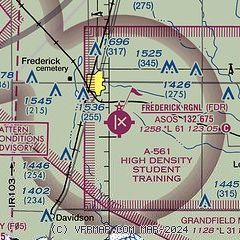
| Sectional chart |
|---|
|
| Airport distance calculator |
|---|
|
|
| Sunrise and sunset |
|---|
|
Times for 15-Nov-2025
| | Local
(UTC-6) | | Zulu
(UTC) |
|---|
| Morning civil twilight | | 06:44 | | 12:44 |
| Sunrise | | 07:10 | | 13:10 |
| Sunset | | 17:31 | | 23:31 |
| Evening civil twilight | | 17:58 | | 23:58 |
|
| Current date and time |
|---|
| Zulu (UTC) | 15-Nov-2025 13:53:18 |
|---|
| Local (UTC-6) | 15-Nov-2025 07:53:18 |
|---|
|
| METAR |
|---|
| KFDR | 151253Z AUTO 23007KT 10SM CLR 11/07 A2983 RMK AO2 SLP090 T01060067
|
KF05
17nm SW | 151335Z AUTO 23006KT 10SM CLR 12/07 A2988 RMK AO2 T01230066
|
|
| TAF |
|---|
KLTS
23nm NW | 141730Z 1417/1523 VRB06KT 9999 SKC QNH2995INS TEMPO 1516/1519 25010G15KT TX26/1421Z TN10/1512Z
|
|
| NOTAMs |
|---|
NOTAMs are issued by the DoD/FAA and will open in a separate window not controlled by AirNav.
|
|

