FAA INFORMATION EFFECTIVE 30 OCTOBER 2025
Location
| FAA Identifier: | F14 |
| Lat/Long: | 33-56-51.3977N 098-36-58.1316W
33-56.856628N 098-36.968860W
33.9476105,-98.6161477
(estimated) |
| Elevation: | 1005.1 ft. / 306.4 m (surveyed) |
| Variation: | 10E (1965) |
| From city: | 8 miles NW of WICHITA FALLS, TX |
| Time zone: | UTC -6 (UTC -5 during Daylight Saving Time) |
| Zip code: | 76367 |
Airport Operations
| Airport use: | Open to the public |
| Activation date: | 03/1946 |
| Control tower: | no |
| ARTCC: | FORT WORTH CENTER |
| FSS: | FORT WORTH FLIGHT SERVICE STATION |
| NOTAMs facility: | FTW (NOTAM-D service available) |
| Attendance: | UNATNDD |
| Wind indicator: | yes |
| Segmented circle: | no |
| Lights: | SS-SR |
Airport Communications
| CTAF/UNICOM: | 122.8 |
| SHEPPARD APPROACH: | 118.2 |
| SHEPPARD DEPARTURE: | 118.2 |
| WX ASOS at SPS (7 nm E): | PHONE 940-208-0073 |
| WX AWOS-3 at CWC (8 nm SE): | 119.625 (940-766-2967) |
- APCH/DEP SVC PRVDD BY FORT WORTH ARTCC (ZFW) ON FREQS 133.5/350.35 (WICHITA FALLS RCAG) WHEN SHEPPARD APCH CLSD.
Nearby radio navigation aids
| VOR radial/distance | | VOR name | | Freq | | Var |
|---|
| SPSr195/2.6 | | WICHITA FALLS VORTAC | | 112.70 | | 10E |
| LAWr188/34.4 | | LAWTON VOR/DME | | 116.85 | | 09E |
Airport Services
| Fuel available: | 100LL
100LL:SELF SVC FUEL. |
| Parking: | hangars and tiedowns |
Runway Information
Runway 13/31
| Dimensions: | 3320 x 40 ft. / 1012 x 12 m |
| Surface: | asphalt, in fair condition |
| Weight bearing capacity: | | Single wheel: | 8.0 | | Double wheel: | 12.5 |
|
| Runway edge lights: | low intensity
RWY 13/31 NSTD LIRL. RWY 13 THLD LGTS 2 GREEN/RED; RWY 31 THLD LGTS 2 GREEN/RED. |
| Runway edge markings: | MARKINGS NSTD; NRS & CNTRLN SMALL. |
| RUNWAY 13 | | RUNWAY 31 |
| Latitude: | 33-57.076517N | | 33-56.650933N |
| Longitude: | 098-37.208550W | | 098-36.795550W |
| Elevation: | 1004.4 ft. | | 981.5 ft. |
| Traffic pattern: | left | | left |
| Runway heading: | 131 magnetic, 141 true | | 311 magnetic, 321 true |
| Markings: | basic, in fair condition | | basic, in fair condition |
| Touchdown point: | yes, no lights | | yes, no lights |
| Obstructions: | 15 ft. road, 200 ft. from runway, 57 ft. right of centerline
4 FT FENCE 0-143 FT DSTC, 15 FT RD 126 FT DSTC. | | 20 ft. tree, 375 ft. from runway, 125 ft. left of centerline, 8:1 slope to clear
6 FT BANK 50 FT DSTC. |
Runway 4/22
| Dimensions: | 3107 x 100 ft. / 947 x 30 m |
| Surface: | turf, in good condition |
| RUNWAY 4 | | RUNWAY 22 |
| Latitude: | 33-56.639100N | | 33-56.972417N |
| Longitude: | 098-37.203483W | | 098-36.736800W |
| Elevation: | 984.0 ft. | | 984.0 ft. |
| Traffic pattern: | left | | left |
| Runway heading: | 039 magnetic, 049 true | | 219 magnetic, 229 true |
| Obstructions: | 34 ft. pline, marked, 50 ft. from runway, 1:1 slope to clear | | 38 ft. trees, 130 ft. from runway, 90 ft. left of centerline, 3:1 slope to clear |
Runway 16/34
| Dimensions: | 2037 x 42 ft. / 621 x 13 m |
| Surface: | turf, in good condition |
| RUNWAY 16 | | RUNWAY 34 |
| Latitude: | 33-57.089083N | | 33-56.755767N |
| Longitude: | 098-36.936817W | | 098-36.886800W |
| Elevation: | 983.0 ft. | | 995.0 ft. |
| Traffic pattern: | left | | left |
| Runway heading: | 163 magnetic, 173 true | | 343 magnetic, 353 true |
| Obstructions: | 4 ft. fence, 80 ft. from runway, 20:1 slope to clear | | 30 ft. pline, lighted, 1000 ft. from runway, 33:1 slope to clear |
Airport Ownership and Management from official FAA records
| Ownership: | Privately-owned |
| Owner: | JOHN HOOKER
2926 HAWS ROAD
IOWA PARK, TX 76367
Phone 940-781-7246 |
| Manager: | JOHN HOOKER
2926 HAWS ROAD
IOWA PARK, TX 76367
Phone 940-781-7246 |
Additional Remarks
| - | UNLGTD TOWER 150'AGL 2MI SOUTH. |
| - | INTENSIVE JET TRAINER TFC 2800-4500 FT MSL VICINITY OF ARPT & SHEPPARD AFB 6 MILES NE. CTC APCH CTL FOR TFC ADVISORIES. |
| - | FOR CD CTC FORT WORTH ARTCC AT 817-858-7584. |
Instrument Procedures
NOTE: All procedures below are presented as PDF files. If you need a reader for these files, you should download the free Adobe Reader.NOT FOR NAVIGATION. Please procure official charts for flight.
FAA instrument procedures published for use from 30 October 2025 at 0901Z to 27 November 2025 at 0900Z.
IAPs - Instrument Approach Procedures |
|---|
| VOR-B | |
download (173KB) |
| NOTE: Special Take-Off Minimums/Departure Procedures apply | |
download (308KB) |
Other nearby airports with instrument procedures:
KSPS - Sheppard Air Force Base/Wichita Falls Municipal Airport (7 nm E)
KCWC - Kickapoo Downtown Airport (8 nm SE)
KFDR - Frederick Regional Airport (30 nm NW)
60F - Seymour Municipal Airport (37 nm SW)
F05 - Wilbarger County Airport (37 nm NW)
|
|

Road maps at:
MapQuest
Bing
Google
| Aerial photo |
|---|
WARNING: Photo may not be current or correct
 Photo taken 01-Aug-2017
looking southwest.
Photo taken 01-Aug-2017
looking southwest.
Do you have a better or more recent aerial photo of Wichita Valley Airport that you would like to share? If so, please send us your photo.
|
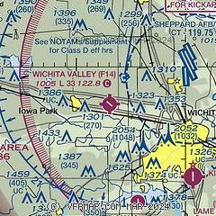
| Sectional chart |
|---|
|
| Airport distance calculator |
|---|
|
|
| Sunrise and sunset |
|---|
|
Times for 19-Nov-2025
| | Local
(UTC-6) | | Zulu
(UTC) |
|---|
| Morning civil twilight | | 06:45 | | 12:45 |
| Sunrise | | 07:12 | | 13:12 |
| Sunset | | 17:28 | | 23:28 |
| Evening civil twilight | | 17:55 | | 23:55 |
|
| Current date and time |
|---|
| Zulu (UTC) | 20-Nov-2025 03:24:27 |
|---|
| Local (UTC-6) | 19-Nov-2025 21:24:27 |
|---|
|
| METAR |
|---|
KSPS
6nm E | 200252Z 16015KT 10SM CLR 21/17 A3001 RMK AO2 LTG DSNT N SLP156 60000 T02060167 57004
|
KCWC
8nm SE | 200255Z AUTO 16007KT 10SM CLR 21/18 A3005 RMK AO2 LTG DSNT E T02060180 PWINO
|
|
| TAF |
|---|
KSPS
6nm E | 191736Z 1918/2018 23004KT P6SM BKN200 FM200000 16008KT P6SM SCT050 OVC150 PROB30 2000/2004 4SM TSRA BKN050CB FM200400 15004KT P6SM SCT050 OVC150 TEMPO 2004/2008 4SM -TSRA BKN050CB FM200800 18007KT 4SM TSRA BKN060CB FM201200 19010KT P6SM -RA OVC060 TEMPO 2012/2016 4SM TSRA BKN060CB
|
|
| NOTAMs |
|---|
NOTAMs are issued by the DoD/FAA and will open in a separate window not controlled by AirNav.
|
|

