FAA INFORMATION EFFECTIVE 02 OCTOBER 2025
Location
| FAA Identifier: | CWC |
| Lat/Long: | 33-51-38.2200N 098-29-25.4350W
33-51.637000N 098-29.423917W
33.8606167,-98.4903986
(estimated) |
| Elevation: | 1003 ft. / 305.7 m (surveyed) |
| Variation: | 04E (2020) |
| From city: | 3 miles S of WICHITA FALLS, TX |
| Time zone: | UTC -5 (UTC -6 during Standard Time) |
| Zip code: | 76302 |
Airport Operations
| Airport use: | Open to the public |
| Activation date: | 05/1940 |
| Control tower: | no |
| ARTCC: | FORT WORTH CENTER |
| FSS: | FORT WORTH FLIGHT SERVICE STATION |
| NOTAMs facility: | FTW (NOTAM-D service available) |
| Attendance: | 0600-2000 |
| Wind indicator: | lighted |
| Segmented circle: | yes |
| Lights: | ACTVT REIL RWYS 17 & 35; MIRL RWY 17/35 - CTAF. |
| Beacon: | white-green (lighted land airport)
Operates sunset to sunrise. |
Airport Communications
| CTAF/UNICOM: | 122.7 |
| WX AWOS-3: | 119.625 (940-766-2967) |
| SHEPPARD APPROACH: | 120.4 |
| SHEPPARD DEPARTURE: | 120.4 |
| CLEARANCE DELIVERY: | 121.2 |
| WX ASOS at SPS (8 nm N): | PHONE 940-208-0073 |
- APCH/DEP SVC PRVDD BY FORT WORTH ARTCC (ZFW) ON FREQS 133.5/350.35 (WICHITA FALLS RCAG) WHEN SHEPPARD APCH CLSD.
Nearby radio navigation aids
| VOR radial/distance | | VOR name | | Freq | | Var |
|---|
| SPSr136/9.2 | | WICHITA FALLS VORTAC | | 112.70 | | 10E |
| LAWr177/38.3 | | LAWTON VOR/DME | | 116.85 | | 09E |
| UKWr294/38.7 | | BOWIE VORTAC | | 117.15 | | 06E |
Airport Services
| Fuel available: | 100LL JET-A
100LL:FULL & SELF SERVE 100 LL & JET A |
| Parking: | hangars and tiedowns |
| Airframe service: | MAJOR |
| Powerplant service: | MAJOR |
| Bottled oxygen: | NONE |
| Bulk oxygen: | NONE |
Runway Information
Runway 17/35
| Dimensions: | 4450 x 75 ft. / 1356 x 23 m |
| Surface: | concrete, in good condition |
| Weight bearing capacity: | |
| Runway edge lights: | medium intensity |
| RUNWAY 17 | | RUNWAY 35 |
| Latitude: | 33-52.003907N | | 33-51.270267N |
| Longitude: | 098-29.421700W | | 098-29.426202W |
| Elevation: | 979.0 ft. | | 1003.0 ft. |
| Traffic pattern: | left | | left |
| Runway heading: | 176 magnetic, 180 true | | 356 magnetic, 000 true |
| Displaced threshold: | 150 ft. | | 250 ft. |
| Markings: | nonprecision, in good condition | | nonprecision, in good condition |
| Visual slope indicator: | 4-light PAPI on left (3.00 degrees glide path) | | 4-light PAPI on left (3.00 degrees glide path) |
| Runway end identifier lights: | yes | | yes |
| Touchdown point: | yes, no lights | | yes, no lights |
| Obstructions: | 5 ft. fence, 201 ft. from runway, 215 ft. left of centerline
5 FT FENCE, 0-199 FT DSTC, 210 FT L. | | 15 ft. road, 314 ft. from runway, 7:1 slope to clear
OBSTN CLNC SLOPE 37:1 TO DSPLCD THR. |
Airport Ownership and Management from official FAA records
| Ownership: | Publicly-owned |
| Owner: | CITY OF WICHITA FALLS
4515 JACKSBORO HWY
WICHITA FALLS, TX 76302
Phone 940-855-3621 |
| Manager: | ANDREW HOLLEY
4515 OLD JACKSBORO HWY
WICHITA FALLS, TX 76302
Phone 940-733-2327 |
Additional Remarks
| - | DO NOT MISTAKE KICKAPOO DOWNTOWN FOR SHEPPARD AFB/WICHITA FALLS MUNI ARPT 7 MILES NORTH. |
| - | INTENSIVE JET TRAINER TFC 2300-3000 FT MSL WITHIN ALERT AREA A-636. REMAIN BLO 1800 FT MSL UNTIL IN RADAR CTC WITH APCH CTL FOR TFC ADVISORIES. |
| - | ANTS 2054 FT MSL 3.5 MI NW OF ARPT. |
| - | FOR CD CTC FORT WORTH ARTCC AT 817-858-7584. |
Instrument Procedures
NOTE: All procedures below are presented as PDF files. If you need a reader for these files, you should download the free Adobe Reader.NOT FOR NAVIGATION. Please procure official charts for flight.
FAA instrument procedures published for use from 02 October 2025 at 0901Z to 30 October 2025 at 0900z.
IAPs - Instrument Approach Procedures |
|---|
| RNAV (GPS) RWY 35 | |
download (221KB) |
| NOTE: Special Alternate Minimums apply | |
download (34KB) |
| NOTE: Special Take-Off Minimums/Departure Procedures apply | |
download (217KB) |
Other nearby airports with instrument procedures:
KSPS - Sheppard Air Force Base/Wichita Falls Municipal Airport (8 nm N)
F14 - Wichita Valley Airport (8 nm NW)
KONY - Olney Municipal Airport (35 nm SW)
KFDR - Frederick Regional Airport (38 nm NW)
0F2 - Bowie Municipal Airport (39 nm SE)
|
|

Road maps at:
MapQuest
Bing
Google
| Aerial photo |
|---|
WARNING: Photo may not be current or correct
 Photo by "The Frog"
Photo taken 07-Oct-2017
looking north-northwest.
Photo by "The Frog"
Photo taken 07-Oct-2017
looking north-northwest.
Do you have a better or more recent aerial photo of Kickapoo Downtown Airport that you would like to share? If so, please send us your photo.
|
| Sectional chart |
|---|
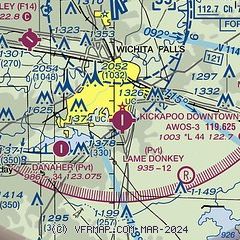
|
| Airport distance calculator |
|---|
|
|
| Sunrise and sunset |
|---|
|
Times for 13-Oct-2025
| | Local
(UTC-5) | | Zulu
(UTC) |
|---|
| Morning civil twilight | | 07:13 | | 12:13 |
| Sunrise | | 07:38 | | 12:38 |
| Sunset | | 19:02 | | 00:02 |
| Evening civil twilight | | 19:27 | | 00:27 |
|
| Current date and time |
|---|
| Zulu (UTC) | 13-Oct-2025 10:23:45 |
|---|
| Local (UTC-5) | 13-Oct-2025 05:23:45 |
|---|
|
| METAR |
|---|
| KCWC | 130955Z AUTO 15008KT 10SM CLR 23/13 A2984 RMK AO2 T02300125
|
KSPS
7nm N | 130952Z AUTO 18011KT 10SM BKN110 23/12 A2981 RMK AO2 SLP080 T02330122
|
|
| TAF |
|---|
KSPS
7nm N | 130520Z 1306/1406 16010KT P6SM SCT080 BKN100 OVC250 FM131300 18008KT P6SM OVC080 FM132300 03009KT P6SM OVC100
|
|
| NOTAMs |
|---|
NOTAMs are issued by the DoD/FAA and will open in a separate window not controlled by AirNav.
|
|

