FAA INFORMATION EFFECTIVE 09 JULY 2026
Location
| FAA Identifier: | CKV |
| Lat/Long: | 36-37-18.7140N 087-24-53.8120W
36-37.311900N 087-24.896867W
36.6218650,-87.4149478
(estimated) |
| Elevation: | 549.9 ft. / 167.6 m (surveyed) |
| Variation: | 01W (1990) |
| From city: | 6 miles NW of CLARKSVILLE, TN |
| Time zone: | UTC -5 (UTC -6 during Standard Time) |
| Zip code: | 37042 |
Airport Operations
| Airport use: | Open to the public |
| Activation date: | 10/1937 |
| Control tower: | no |
| ARTCC: | MEMPHIS CENTER |
| FSS: | JACKSON FLIGHT SERVICE STATION |
| NOTAMs facility: | CKV (NOTAM-D service available) |
| Attendance: | MON-FRI 0700-1800, ALL SAT-SUN 0800-1600
ARPT UNATNDD CHRISTMAS, THANKSGIVING & NEW YEAR. |
| Pattern altitude: | 1599.9 ft. MSL |
| Wind indicator: | lighted |
| Segmented circle: | yes |
| Lights: | ACTVT MALS RWY 35; REIL RWY 17 - CTAF. |
| Beacon: | white-green (lighted land airport)
Operates sunset to sunrise. |
Airport Communications
| CTAF/UNICOM: | 122.8 |
| WX ASOS: | 134.575 (931-431-3045) |
| CAMPBELL APPROACH: | 134.35 [0600-2350] |
| CAMPBELL DEPARTURE: | 134.35 [0600-2350] |
| WX AWOS-3 at EOD (5 nm SW): | PHONE 270-956-3100 |
| WX AWOS-3 at HVC (14 nm N): | 132.575 (270-886-6311) |
Nearby radio navigation aids
| VOR radial/distance | | VOR name | | Freq | | Var |
|---|
| CKV at field | | CLARKSVILLE VOR/DME | | 110.60 | | 01W |
| NDB name | | Hdg/Dist | | Freq | | Var | | ID |
|---|
| SNUFF | | 348/5.8 | | 335 | | 01W | | CK | -.-. -.- |
| AIRBE | | 181/6.9 | | 273 | | 01W | | FK | ..-. -.- |
Airport Services
| Fuel available: | 100LL JET-A+
100LL:AFT HR SVC - 931-217-8765. |
| Parking: | hangars and tiedowns |
| Airframe service: | MAJOR |
| Powerplant service: | MAJOR |
Runway Information
Runway 17/35
| Dimensions: | 5999 x 100 ft. / 1828 x 30 m |
| Surface: | asphalt, in excellent condition |
| Weight bearing capacity: | | PCN 27 /F/C/X/T | | Single wheel: | 71.0 | | Double wheel: | 94.0 |
|
| Runway edge lights: | medium intensity |
| RUNWAY 17 | | RUNWAY 35 |
| Latitude: | 36-37.767953N | | 36-36.808082N |
| Longitude: | 087-25.055048W | | 087-24.761248W |
| Elevation: | 538.0 ft. | | 549.0 ft. |
| Traffic pattern: | left | | right |
| Runway heading: | 167 magnetic, 166 true | | 347 magnetic, 346 true |
| Markings: | nonprecision, in good condition | | nonprecision, in good condition |
| Visual slope indicator: | 2-light PAPI on left (3.00 degrees glide path)
PAPI RWY 17 UNUSBL BYD 9 DEGS RIGHT OF CNTLN. | | 2-light PAPI on left (3.00 degrees glide path) |
| Approach lights: | | | MALS: 1,400 foot medium intensity approach lighting system |
| Runway end identifier lights: | yes | | |
| Touchdown point: | yes, no lights | | yes, no lights |
| Instrument approach: | | | LOCALIZER |
| Obstructions: | 101 ft. tree, 2357 ft. from runway, 484 ft. right of centerline, 21:1 slope to clear | | 75 ft. tree, 2156 ft. from runway, 377 ft. left of centerline, 26:1 slope to clear |
Runway 5/23
| Dimensions: | 4004 x 100 ft. / 1220 x 30 m |
| Surface: | asphalt, in fair condition |
| Weight bearing capacity: | | Single wheel: | 40.0 | | Double wheel: | 60.0 |
|
| Runway edge markings: | PEELING & FADED. |
| Operational restrictions: | CLSD INDEFLY. |
| RUNWAY 5 | | RUNWAY 23 |
| Latitude: | 36-37.144793N | | 36-37.550575N |
| Longitude: | 087-25.202745W | | 087-24.557227W |
| Elevation: | 539.3 ft. | | 532.7 ft. |
| Traffic pattern: | right | | left |
| Runway heading: | 053 magnetic, 052 true | | 233 magnetic, 232 true |
| Displaced threshold: | 402 ft. | | 503 ft. |
| Declared distances: | TORA:4004 TODA:4004 ASDA:3501 LDA:3099 | | TORA:4004 TODA:4004 ASDA:3602 LDA:3099 |
| Markings: | nonprecision, in poor condition | | nonprecision, in poor condition |
| Touchdown point: | yes, no lights | | yes, no lights |
| Obstructions: | 44 ft. tree, 365 ft. from runway, 63 ft. right of centerline, 3:1 slope to clear
FENCE 100 FT FM RWY END. | | 86 ft. tree, 1057 ft. from runway, 28 ft. left of centerline, 9:1 slope to clear
FENCE 100 FT FM RWY END. |
Airport Ownership and Management from official FAA records
| Ownership: | Publicly-owned |
| Owner: | CLARKSVILLE MONTGOMERY COUNTY RAA
200 A OUTLAW FIELD ROAD
CLARKSVILLE, TN 37042
Phone 931-431-2080 |
| Manager: | JOHN PATTERSON
200 AIRPORT ROAD - BLDG 1
CLARKSVILLE, TN 37042
Phone 931-431-2080 |
Additional Remarks
| - | EXTSV MIL & CIVIL FLIGHT TRNG WITHIN ARPT AREA. |
| - | DEER ON & INVOF ARPT. |
| - | FOR CD WHEN UNA VIA FREQ CTC CAMPBELL APCH AT 270-798-6441. |
Instrument Procedures
NOTE: All procedures below are presented as PDF files. If you need a reader for these files, you should download the free Adobe Reader.NOT FOR NAVIGATION. Please procure official charts for flight.
FAA instrument procedures published for use from 09 July 2026 at 0901Z to 06 August 2026 at 0900Z.
IAPs - Instrument Approach Procedures |
|---|
| RNAV (GPS) RWY 17 | |
download (195KB) |
| RNAV (GPS) RWY 35 | |
download (269KB) |
| LOC RWY 35 | |
download (271KB) |
| VOR RWY 35 | |
download (189KB) |
| NOTE: Special Alternate Minimums apply | |
download (160KB) |
| NOTE: Special Take-Off Minimums/Departure Procedures apply | |
download (373KB) |
Other nearby airports with instrument procedures:
KEOD - Sabre Army Airfield (Fort Campbell) (5 nm SW)
KHOP - Campbell Army Airfield (Fort Campbell) (5 nm NW)
KHVC - Hopkinsville-Christian County Airport (14 nm N)
M91 - Springfield Robertson County Airport (24 nm E)
M02 - Dickson Municipal Airport (30 nm S)
|
|

Road maps at:
MapQuest
Bing
Google
| Aerial photo |
|---|
WARNING: Photo may not be current or correct

Do you have a better or more recent aerial photo of Outlaw Field Airport that you would like to share? If so, please send us your photo.
|
| Sectional chart |
|---|
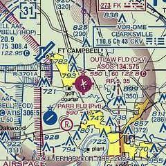
|
CAUTION: Diagram may not be current

| Airport distance calculator |
|---|
|
|
| Sunrise and sunset |
|---|
|
Times for 27-Jul-2026
| | Local
(UTC-5) | | Zulu
(UTC) |
|---|
| Morning civil twilight | | 05:24 | | 10:24 |
| Sunrise | | 05:53 | | 10:53 |
| Sunset | | 20:00 | | 01:00 |
| Evening civil twilight | | 20:29 | | 01:29 |
|
| Current date and time |
|---|
| Zulu (UTC) | 28-Jul-2026 00:35:28 |
|---|
| Local (UTC-5) | 27-Jul-2026 19:35:28 |
|---|
|
| METAR |
|---|
| KCKV | 272352Z AUTO 00000KT 10SM CLR 31/25 A2984 RMK AO2 SLP097 T03110250 10339 20311 56012 $
|
KEOD
5nm SW | 272355Z AUTO 17003KT 10SM CLR 31/27 A2986 RMK AO2 SLP108 T03070268 10340 20306 57011
|
KHOP
5nm NW | 272355Z AUTO 18003KT 10SM CLR 32/23 A2982 RMK AO2 SLP093 T03180233 10337 20310 57011 $
|
KHVC
14nm N | 280015Z AUTO 20004KT 10SM CLR 31/24 A2983 RMK A01
|
|
| TAF |
|---|
| KCKV | 271739Z 2718/2818 VRB05KT P6SM FEW050 SCT250 FM280300 22006KT P6SM SCT250 FM281500 29010G15KT P6SM SCT040
|
KHOP
5nm NW | 280000Z 2800/2906 23006KT 9999 BKN200 QNH2979INS BECMG 2803/2804 21010G15KT 8000 -SHRA BKN030 QNH2976INS BECMG 2808/2809 24009KT 9999 NSW BKN025 QNH2975INS TX30/2419Z TN17/2410Z
|
|
| NOTAMs |
|---|
NOTAMs are issued by the DoD/FAA and will open in a separate window not controlled by AirNav.
|
|


