FAA INFORMATION EFFECTIVE 27 NOVEMBER 2025
Location
| FAA Identifier: | CXP |
| Lat/Long: | 39-11-32.2950N 119-43-57.2540W
39-11.538250N 119-43.954233W
39.1923042,-119.7325706
(estimated) |
| Elevation: | 4704.4 ft. / 1433.9 m (surveyed) |
| Variation: | 14E (2010) |
| From city: | 3 miles NE of CARSON CITY, NV |
| Time zone: | UTC -8 (UTC -7 during Daylight Saving Time) |
| Zip code: | 89706 |
Airport Operations
| Airport use: | Open to the public |
| Activation date: | 04/1940 |
| Control tower: | no |
| ARTCC: | OAKLAND CENTER |
| FSS: | RENO FLIGHT SERVICE STATION |
| NOTAMs facility: | CXP (NOTAM-D service available) |
| Attendance: | 0600-2000 |
| Wind indicator: | lighted |
| Segmented circle: | yes |
| Lights: | ACTVT REIL RWY 09 & 27; MIRL RWY 09/27 - CTAF. PAPI RWY 09 & 27 ON CONSLY. |
| Beacon: | white-green (lighted land airport)
Operates sunset to sunrise. |
Airport Communications
| CTAF/UNICOM: | 123.0 |
| WX AWOS-3PT: | 119.925 (775-884-4708) |
| NORCAL APPROACH: | 119.2 |
| NORCAL DEPARTURE: | 119.2 |
| CLEARANCE DELIVERY: | 133.25 |
| WX AWOS-3PT at MEV (12 nm S): | 119.325 (775-782-6264) |
| WX ASOS at RNO (18 nm N): | 135.8 (775-432-6755) |
Nearby radio navigation aids
| VOR radial/distance | | VOR name | | Freq | | Var |
|---|
| FMGr174/20.6 | | MUSTANG VORTAC | | 117.90 | | 16E |
| SWRr072/25.0 | | PALISADES VOR/DME | | 113.20 | | 16E |
| HZNr223/39.2 | | HAZEN VORTAC | | 114.10 | | 17E |
Airport Services
| Fuel available: | 100LL JET-A |
| Parking: | hangars and tiedowns |
| Airframe service: | MAJOR |
| Powerplant service: | MAJOR |
| Bottled oxygen: | HIGH |
| Bulk oxygen: | HIGH |
Runway Information
Runway 9/27
| Dimensions: | 6101 x 75 ft. / 1860 x 23 m |
| Surface: | asphalt/grooved, in excellent condition |
| Weight bearing capacity: | | Single wheel: | 30.0 | | Double wheel: | 60.0 |
|
| Runway edge lights: | medium intensity |
| RUNWAY 9 | | RUNWAY 27 |
| Latitude: | 39-11.653595N | | 39-11.422860N |
| Longitude: | 119-44.582650W | | 119-43.325857W |
| Elevation: | 4704.4 ft. | | 4695.1 ft. |
| Traffic pattern: | right | | left |
| Runway heading: | 089 magnetic, 103 true | | 269 magnetic, 283 true |
| Markings: | nonprecision, in good condition | | nonprecision, in good condition |
| Visual slope indicator: | 2-light PAPI on left (4.00 degrees glide path)
UNUSBL BYD 2 NM FM RWY THR; BYD 3 DEGS LEFT AND RIGHT OF CNTRLN; AT NGT. | | 2-light PAPI on left (3.77 degrees glide path)
UNUSBL BYD 1.3 NM. |
| Runway end identifier lights: | yes | | yes |
| Touchdown point: | yes, no lights | | yes, no lights |
| Obstructions: | 55 ft. hill, 1739 ft. from runway, 286 ft. both sides of centerline, 28:1 slope to clear | | none |
Airport Ownership and Management from official FAA records
| Ownership: | Publicly-owned |
| Owner: | CARSON CITY AIRPORT AUTHORITY
2600 E. COLLEGE PARKWAY, NO. 6
CARSON CITY, NV 89706
Phone 775-841-2255 |
| Manager: | COREY JENKINS
2600 E. COLLEGE PARKWAY #6
CARSON CITY, NV 89706
Phone 775-841-2255 |
Additional Remarks
| - | RY 27 IS PREF CALM WIND RY. |
| - | COLD TEMPERATURE AIRPORT. ALTITUDE CORRECTION REQUIRED AT OR BELOW -18C. |
| - | UAS/UAV, ULTRALIGHT, GLIDER ACT ON AND INVOF ARPT. |
| - | FOR CD CTC NORCAL APCH AT 916-361-6874. |
| - | ARPT OPS AFT HRS CTC FONE 775-443-7288. |
Instrument Procedures
NOTE: All procedures below are presented as PDF files. If you need a reader for these files, you should download the free Adobe Reader.NOT FOR NAVIGATION. Please procure official charts for flight.
FAA instrument procedures published for use from 27 November 2025 at 0901Z to 25 December 2025 at 0900Z.
IAPs - Instrument Approach Procedures |
|---|
| RNAV (GPS) RWY 27 | |
download (394KB) |
| RNAV (GPS)-A | |
download (389KB) |
| RNAV (GPS)-B | |
download (340KB) |
| NOTE: Special Alternate Minimums apply | |
download (128KB) |
|
|---|
| JIMPA TWO (OBSTACLE) (RNAV) | |
download (136KB) |
| NOTE: Special Take-Off Minimums/Departure Procedures apply | |
download (357KB) |
Other nearby airports with instrument procedures:
KMEV - Minden-Tahoe Airport (12 nm S)
KRNO - Reno/Tahoe International Airport (18 nm N)
KTRK - Truckee-Tahoe Airport (20 nm W)
KTVL - Lake Tahoe Airport (22 nm SW)
KSPZ - Silver Springs Airport (26 nm NE)
|
|

Road maps at:
MapQuest
Bing
Google
| Aerial photo |
|---|
WARNING: Photo may not be current or correct
 Photo by David Byrne focalflight.com
Photo taken 18-Aug-2011
looking south.
Photo by David Byrne focalflight.com
Photo taken 18-Aug-2011
looking south.
Do you have a better or more recent aerial photo of Carson City Airport that you would like to share? If so, please send us your photo.
|
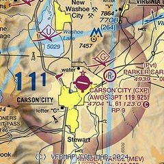
| Sectional chart |
|---|
|
CAUTION: Diagram may not be current

| Airport distance calculator |
|---|
|
|
| Sunrise and sunset |
|---|
|
Times for 08-Dec-2025
| | Local
(UTC-8) | | Zulu
(UTC) |
|---|
| Morning civil twilight | | 06:37 | | 14:37 |
| Sunrise | | 07:07 | | 15:07 |
| Sunset | | 16:35 | | 00:35 |
| Evening civil twilight | | 17:05 | | 01:05 |
|
| Current date and time |
|---|
| Zulu (UTC) | 09-Dec-2025 00:54:15 |
|---|
| Local (UTC-8) | 08-Dec-2025 16:54:15 |
|---|
|
| METAR |
|---|
| KCXP | 090035Z AUTO 00000KT 10SM CLR 11/M03 A3035 RMK AO2
|
KMEV
12nm S | 090035Z AUTO 00000KT 10SM CLR 10/M03 A3034 RMK AO2
|
KRNO
18nm N | 082355Z 19005KT 10SM SCT250 14/M02 A3033 RMK AO2 SLP261 T01441017 10150 20050 55009
|
KTRK
19nm NW | 082350Z 00000KT 10SM CLR 13/01 A3038
|
|
| TAF |
|---|
| KCXP | 081752Z 0818/0918 VRB03KT P6SM FEW220 FM082100 09008KT P6SM FEW140 FEW220 FM090200 VRB03KT P6SM FEW220
|
KMEV
12nm S | 081752Z 0818/0918 VRB05KT P6SM FEW140 FEW220
|
KRNO
18nm N | 081752Z 0818/0918 VRB05KT P6SM FEW220
|
KTRK
19nm NW | 081752Z 0818/0918 VRB04KT P6SM FEW200
|
|
| NOTAMs |
|---|
NOTAMs are issued by the DoD/FAA and will open in a separate window not controlled by AirNav.
|
|


