FAA INFORMATION EFFECTIVE 27 NOVEMBER 2025
Location
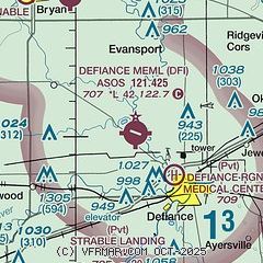
| FAA Identifier: | DFI |
| Lat/Long: | 41-20-15.0000N 084-25-43.7000W
41-20.250000N 084-25.728333W
41.3375000,-84.4288056
(estimated) |
| Elevation: | 706.9 ft. / 215.5 m (surveyed) |
| Variation: | 05W (2000) |
| From city: | 4 miles NW of DEFIANCE, OH |
| Time zone: | UTC -5 (UTC -4 during Daylight Saving Time) |
| Zip code: | 43512 |
Airport Operations
| Airport use: | Open to the public |
| Activation date: | 10/1945 |
| Control tower: | no |
| ARTCC: | CLEVELAND CENTER |
| FSS: | CLEVELAND FLIGHT SERVICE STATION |
| NOTAMs facility: | DFI (NOTAM-D service available) |
| Attendance: | MON-FRI 0800-1800, ALL SAT 0800-1200 |
| Wind indicator: | lighted |
| Segmented circle: | no |
| Lights: | ACTVT OR INCR INTST REIL RWY 12 & 30; PAPI RWY 12; MIRL RWY 12/30 - CTAF. MIRL RWY 12/30 PRESET LOW INTST. |
| Beacon: | white-green (lighted land airport)
Operates sunset to sunrise. |
Airport Communications
| CTAF/UNICOM: | 122.7 |
| WX ASOS: | 121.425 (419-658-2301) |
| TOLEDO APPROACH: | 134.35 |
| TOLEDO DEPARTURE: | 134.35 |
Nearby radio navigation aids
| VOR radial/distance | | VOR name | | Freq | | Var |
|---|
| FBCr309/38.1 | | FLAG CITY VORTAC | | 108.20 | | 02W |
| NDB name | | Hdg/Dist | | Freq | | Var | | ID |
|---|
| ADRIAN | | 212/35.6 | | 278 | | 06W | | ADG | .- -.. --. |
Airport Services
| Fuel available: | 100LL JET-A+
100LL:100LL & JET A+ AVBL H24 SELF SVC VIA CREDIT CARD. |
| Parking: | hangars and tiedowns |
| Airframe service: | MAJOR |
| Powerplant service: | MAJOR |
| Bottled oxygen: | LOW |
| Bulk oxygen: | NONE |
Runway Information
Runway 12/30
| Dimensions: | 4199 x 72 ft. / 1280 x 22 m |
| Surface: | asphalt, in good condition |
| Runway edge lights: | medium intensity |
| RUNWAY 12 | | RUNWAY 30 |
| Latitude: | 41-20.395040N | | 41-20.104447N |
| Longitude: | 084-26.144535W | | 084-25.312162W |
| Elevation: | 706.9 ft. | | 699.5 ft. |
| Traffic pattern: | left | | left |
| Runway heading: | 120 magnetic, 115 true | | 300 magnetic, 295 true |
| Markings: | nonprecision, in good condition | | nonprecision, in good condition |
| Visual slope indicator: | 4-light PAPI on left (3.00 degrees glide path) | | pulsating/steady burning VASI on left |
| Runway end identifier lights: | yes | | yes |
| Touchdown point: | yes, no lights | | yes, no lights |
| Obstructions: | 60 ft. trees, 1445 ft. from runway, 103 ft. left of centerline, 20:1 slope to clear | | 75 ft. trees, 1385 ft. from runway, 252 ft. right of centerline, 15:1 slope to clear |
Airport Ownership and Management from official FAA records
| Ownership: | Publicly-owned |
| Owner: | BOARD OF CO COMMISSIONERS
500 COURT ST STE A
DEFIANCE, OH 43512-2171
Phone 419-782-4761 |
| Manager: | TONY SAXTON
20399 AIRPORT RD
DEFIANCE, OH 43512-6763
Phone 419-658-4444
TONY@TAS-AVIATION.COM. |
Additional Remarks
| - | DEER, BIRDS, & WILDLIFE ON & INVOF ARPT. |
| - | FOR CD CTC TOLEDO APCH AT 419-865-1495. |
| - | FOR AFT HRS ACES TO LOBBY SEE SIGN ON TRML DOOR. |
Instrument Procedures
NOTE: All procedures below are presented as PDF files. If you need a reader for these files, you should download the free Adobe Reader.NOT FOR NAVIGATION. Please procure official charts for flight.
FAA instrument procedures published for use from 27 November 2025 at 0901Z to 25 December 2025 at 0900Z.
IAPs - Instrument Approach Procedures |
|---|
| RNAV (GPS) RWY 12 | |
download (194KB) |
| NOTE: Special Alternate Minimums apply | |
download (144KB) |
| NOTE: Special Take-Off Minimums/Departure Procedures apply | |
download (460KB) |
Other nearby airports with instrument procedures:
0G6 - Williams County Airport (9 nm NW)
7W5 - Henry County Airport (16 nm E)
KUSE - Fulton County Airport (21 nm NE)
KOWX - Putnam County Airport (27 nm SE)
KGWB - Auburn/Dekalb Executive Airport (29 nm W)
|
|

Road maps at:
MapQuest
Bing
Google
| Aerial photo |
|---|
WARNING: Photo may not be current or correct

Do you have a better or more recent aerial photo of Defiance Memorial Airport that you would like to share? If so, please send us your photo.
|
| Sectional chart |
|---|
|
| Airport distance calculator |
|---|
|
|
| Sunrise and sunset |
|---|
|
Times for 11-Dec-2025
| | Local
(UTC-5) | | Zulu
(UTC) |
|---|
| Morning civil twilight | | 07:23 | | 12:23 |
| Sunrise | | 07:55 | | 12:55 |
| Sunset | | 17:07 | | 22:07 |
| Evening civil twilight | | 17:39 | | 22:39 |
|
| Current date and time |
|---|
| Zulu (UTC) | 11-Dec-2025 09:27:40 |
|---|
| Local (UTC-5) | 11-Dec-2025 04:27:40 |
|---|
|
| METAR |
|---|
| KDFI | 110853Z AUTO 22003KT 10SM OVC036 M03/M07 A2990 RMK AO2 SNE0754 SLP133 P0000 60000 T10331072 51007
|
|
| TAF |
|---|
KTOL
32nm NE | 110526Z 1106/1206 31010G18KT P6SM BKN035 FM110900 27008KT P6SM BKN040 TEMPO 1114/1117 SCT035
|
KFDY
39nm SE | 110526Z 1106/1206 32012G20KT P6SM OVC035 FM111300 28011KT P6SM VCSH BKN025 FM111900 27010KT P6SM BKN035
|
|
| NOTAMs |
|---|
NOTAMs are issued by the DoD/FAA and will open in a separate window not controlled by AirNav.
|
|


