FAA INFORMATION EFFECTIVE 14 MAY 2026
Location
| FAA Identifier: | DKR |
| Lat/Long: | 31-18-25.1000N 095-24-13.8000W
31-18.418333N 095-24.230000W
31.3069722,-95.4038333
(estimated) |
| Elevation: | 348.4 ft. / 106.2 m (surveyed) |
| Variation: | 05E (2000) |
| From city: | 3 miles SE of CROCKETT, TX |
| Time zone: | UTC -5 (UTC -6 during Standard Time) |
| Zip code: | 75835 |
Airport Operations
| Airport use: | Open to the public |
| Activation date: | 09/1961 |
| Control tower: | no |
| ARTCC: | HOUSTON CENTER |
| FSS: | MONTGOMERY COUNTY FLIGHT SERVICE STATION |
| NOTAMs facility: | DKR (NOTAM-D service available) |
| Attendance: | UNATNDD |
| Wind indicator: | lighted |
| Segmented circle: | yes |
| Lights: | MIRL RY 02/20 PRESET LOW INTST; TO INCR INTST ACTVT - CTAF. MIRLS OPER WITH PHOTOCELL OPERG ONLY AT NIGHT WITH SLCTBL INTST ON CTAF. |
| Beacon: | white-green (lighted land airport)
Operates sunset to sunrise. |
Airport Communications
| CTAF: | 122.9 |
| WX AWOS-3PT: | 118.775 (936-545-8510) |
- APCH/DEP CTL SVC PRVDD BY HOUSTON ARTCC (ZHU) ON FREQS 134.8/269.6 (LUFKIN/A RCAG).
Nearby radio navigation aids
| VOR radial/distance | | VOR name | | Freq | | Var |
|---|
| LOAr061/31.0 | | LEONA VORTAC | | 110.80 | | 08E |
| LFKr279/36.3 | | LUFKIN VORTAC | | 112.10 | | 05E |
Airport Services
| Fuel available: | 100LL
100LL:SELF SERVE FUEL. |
| Parking: | tiedowns |
| Airframe service: | MAJOR |
| Powerplant service: | MAJOR |
| Bottled oxygen: | NONE |
| Bulk oxygen: | NONE |
Runway Information
Runway 2/20
| Dimensions: | 4000 x 75 ft. / 1219 x 23 m |
| Surface: | asphalt, in good condition |
| Weight bearing capacity: | |
| Runway edge lights: | medium intensity |
| RUNWAY 2 | | RUNWAY 20 |
| Latitude: | 31-18.110722N | | 31-18.724447N |
| Longitude: | 095-24.370865W | | 095-24.089097W |
| Elevation: | 326.7 ft. | | 348.4 ft. |
| Traffic pattern: | left | | left |
| Runway heading: | 017 magnetic, 022 true | | 197 magnetic, 202 true |
| Markings: | nonprecision, in good condition | | nonprecision, in good condition |
| Visual slope indicator: | 2-light PAPI on left (3.00 degrees glide path)
PAPI OTS INDEFLY. | | 2-light PAPI on left (3.00 degrees glide path)
PAPI OTS INDEFLY. |
| Touchdown point: | yes, no lights | | yes, no lights |
| Obstructions: | 18 ft. tree, 352 ft. from runway, 263 ft. right of centerline, 8:1 slope to clear
8 FT TREES, 120 FT DSTC, 180 FT R. | | 21 ft. road, 620 ft. from runway, 320 ft. right of centerline, 20:1 slope to clear |
Airport Ownership and Management from official FAA records
| Ownership: | Publicly-owned |
| Owner: | HOUSTON COUNTY
HOUSTON COUNTY COURTHOUSE, 401 E HOUSTON AVE
CROCKETT, TX 75835
Phone 936-544-3255
EXT 221 |
| Manager: | JIM LOVELL
HOUSTON COUNTY COURTHOUSE, 401 E HOUSTON AVE - SUITE 201
CROCKETT, TX 75835
Phone 936-544-3255
EXTENSION 221. |
Additional Remarks
| - | FOR CD CTC HOUSTON ARTCC AT 281-230-5622. |
Instrument Procedures
NOTE: All procedures below are presented as PDF files. If you need a reader for these files, you should download the free Adobe Reader.NOT FOR NAVIGATION. Please procure official charts for flight.
FAA instrument procedures published for use from 14 May 2026 at 0901Z to 11 June 2026 at 0900Z.
IAPs - Instrument Approach Procedures |
|---|
| RNAV (GPS) RWY 02 | |
download (191KB) |
| RNAV (GPS) RWY 20 | |
download (181KB) |
| NOTE: Special Alternate Minimums apply | |
download (43KB) |
| NOTE: Special Take-Off Minimums/Departure Procedures apply | |
download (70KB) |
Other nearby airports with instrument procedures:
KPSN - Palestine Municipal Airport (32 nm NW)
KLFK - Angelina County Airport (34 nm E)
KUTS - Huntsville Municipal Airport (35 nm S)
KJSO - Cherokee County Airport (35 nm N)
51R - Madisonville Municipal Airport (37 nm SW)
|
|

Road maps at:
MapQuest
Bing
Google
| Aerial photo |
|---|
WARNING: Photo may not be current or correct
 Photo by Mark Whitfill
Taken in May 2009
Photo by Mark Whitfill
Taken in May 2009
Do you have a better or more recent aerial photo of Houston County Airport that you would like to share? If so, please send us your photo.
|
| Sectional chart |
|---|
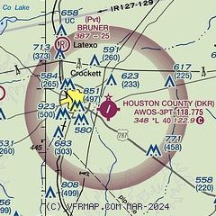
|
| Airport distance calculator |
|---|
|
|
| Sunrise and sunset |
|---|
|
Times for 19-May-2026
| | Local
(UTC-5) | | Zulu
(UTC) |
|---|
| Morning civil twilight | | 05:57 | | 10:57 |
| Sunrise | | 06:24 | | 11:24 |
| Sunset | | 20:12 | | 01:12 |
| Evening civil twilight | | 20:39 | | 01:39 |
|
| Current date and time |
|---|
| Zulu (UTC) | 19-May-2026 23:44:40 |
|---|
| Local (UTC-5) | 19-May-2026 18:44:40 |
|---|
|
| TAF |
|---|
KLFK
34nm E | 192025Z 1920/2018 13006KT P6SM VCTS FEW030CB FEW060 TEMPO 1920/1924 VRB15G30KT 3SM TSRA BR OVC035CB FM200000 VRB15G30KT 1SM +TSRA BR OVC025CB FM200300 07006KT 4SM BR VCSH SCT009 OVC015 FM200500 09006KT 6SM BR OVC005 FM201700 10005KT P6SM SCT010 OVC018
|
KUTS
35nm S | 192014Z 1920/2018 16012KT P6SM VCTS SCT030CB TEMPO 1920/1923 6SM -TSRA BKN030CB FM200000 10010KT 5SM -SHRA VCTS BKN040CB TEMPO 2000/2004 VRB15G30KT 3SM TSRA BKN025CB FM200500 09007KT 6SM BR VCSH SCT007 OVC015 FM200900 12010KT 6SM BR BKN007 OVC020 TEMPO 2011/2015 10012KT 4SM TSRA BKN025CB FM201600 11009KT P6SM SCT008 BKN025
|
|
| NOTAMs |
|---|
NOTAMs are issued by the DoD/FAA and will open in a separate window not controlled by AirNav.
|
|

