FAA INFORMATION EFFECTIVE 11 JUNE 2026
Location
| FAA Identifier: | DNV |
| Lat/Long: | 40-11-59.3780N 087-35-42.5990W
40-11.989633N 087-35.709983W
40.1998272,-87.5951664
(estimated) |
| Elevation: | 696.9 ft. / 212.4 m (surveyed) |
| Variation: | 01W (1985) |
| From city: | 4 miles NE of DANVILLE, IL |
| Time zone: | UTC -5 (UTC -6 during Standard Time) |
| Zip code: | 61814 |
Airport Operations
| Airport use: | Open to the public |
| Activation date: | 03/1951 |
| Control tower: | no |
| ARTCC: | CHICAGO CENTER |
| FSS: | SAINT LOUIS FLIGHT SERVICE STATION |
| NOTAMs facility: | DNV (NOTAM-D service available) |
| Attendance: | 0700-2200 |
| Wind indicator: | lighted |
| Segmented circle: | no |
| Lights: | HIRL RWY 03/21 PRESET LOW INTST - TO INCR INTST & ACTVT MALSR RWY 21; VASI RWYS 03, 16 & 34; PAPI RWY 21; MIRL RWY 16/34 - CTAF. |
| Beacon: | white-green (lighted land airport)
Operates sunset to sunrise. |
Airport Communications
| CTAF/UNICOM: | 122.7 |
| WX AWOS-3: | 119.275 (217-442-4660) |
| CHAMPAIGN APPROACH: | 121.35 |
| CHAMPAIGN DEPARTURE: | 121.35 |
| CLEARANCE DELIVERY: | 121.7 |
- APCH/DEP SVC PRVDD BY CHICAGO ARTCC ON REMOTED CHAMPAIGN APCH CTL FREQS 121.35 & 353.95 (DANVILLE RCAG) WHEN CHAMPAIGN APCH CTL CLSD.
Nearby radio navigation aids
| VOR radial/distance | | VOR name | | Freq | | Var |
|---|
| BVTr227/32.2 | | BOILER VORTAC | | 115.10 | | 01E |
| CMIr069/32.8 | | CHAMPAIGN VORTAC | | 115.75 | | 03E |
| RBSr129/34.7 | | ROBERTS VOR/DME | | 116.80 | | 02E |
| NDB name | | Hdg/Dist | | Freq | | Var | | ID |
|---|
| JULIP | | 209/6.2 | | 332 | | 00E | | DN | -.. -. |
| CRAWFORDSVILLE | | 297/33.8 | | 388 | | 04W | | CFJ | -.-. ..-. .--- |
Airport Services
| Fuel available: | 100LL JET-A |
| Parking: | hangars and tiedowns |
| Airframe service: | MAJOR |
| Powerplant service: | MAJOR |
| Bottled oxygen: | NONE |
| Bulk oxygen: | NONE |
Runway Information
Runway 3/21
| Dimensions: | 6006 x 100 ft. / 1831 x 30 m |
| Surface: | asphalt/porous friction courses, in good condition |
| Weight bearing capacity: | | Single wheel: | 50.0 | | Double wheel: | 75.0 |
|
| Runway edge lights: | high intensity |
| RUNWAY 3 | | RUNWAY 21 |
| Latitude: | 40-11.626805N | | 40-12.490083N |
| Longitude: | 087-35.977225W | | 087-35.348140W |
| Elevation: | 651.3 ft. | | 696.9 ft. |
| Traffic pattern: | left | | left |
| Runway heading: | 030 magnetic, 029 true | | 210 magnetic, 209 true |
| Markings: | nonprecision, in good condition | | precision, in good condition |
| Visual slope indicator: | 4-box VASI on left (3.00 degrees glide path) | | 4-light PAPI on left (3.00 degrees glide path) |
| Approach lights: | | | MALSR: 1,400 foot medium intensity approach lighting system with runway alignment indicator lights |
| Runway end identifier lights: | no | | no |
| Touchdown point: | yes, no lights | | yes, no lights |
| Instrument approach: | | | ILS |
| Obstructions: | 39 ft. tree, 1529 ft. from runway, 34:1 slope to clear | | none |
Runway 16/34
| Dimensions: | 3999 x 100 ft. / 1219 x 30 m |
| Surface: | asphalt/grooved, in good condition |
| Weight bearing capacity: | | Single wheel: | 40.0 | | Double wheel: | 50.0 |
|
| Runway edge lights: | medium intensity |
| RUNWAY 16 | | RUNWAY 34 |
| Latitude: | 40-12.183643N | | 40-11.549892N |
| Longitude: | 087-35.950740W | | 087-35.716920W |
| Elevation: | 681.8 ft. | | 656.3 ft. |
| Traffic pattern: | left | | left |
| Runway heading: | 165 magnetic, 164 true | | 345 magnetic, 344 true |
| Markings: | basic, in good condition | | nonprecision, in good condition |
| Visual slope indicator: | 2-box VASI on left (3.00 degrees glide path) | | 2-box VASI on left (3.00 degrees glide path) |
| Runway end identifier lights: | no | | no |
| Touchdown point: | yes, no lights | | yes, no lights |
Runway 12/30
| Dimensions: | 2500 x 150 ft. / 762 x 46 m |
| Surface: | turf, in good condition |
| Operational restrictions: | SEASONAL RWY NOV 1 - MAY 1; CTC AMGR 217-442-4624. |
| RUNWAY 12 | | RUNWAY 30 |
| Latitude: | 40-12.121900N | | 40-11.919867N |
| Longitude: | 087-35.859450W | | 087-35.391483W |
| Elevation: | 678.2 ft. | | 670.8 ft. |
| Traffic pattern: | left | | left |
| Runway heading: | 120 magnetic, 119 true | | 300 magnetic, 299 true |
| Markings: | none | | none |
| Touchdown point: | yes, no lights | | yes, no lights |
Airport Ownership and Management from official FAA records
| Ownership: | Publicly-owned |
| Owner: | VERMILION REGIONAL ARPT AUTH
22633 N. BOWMAN AVE. , SUITE 1
DANVILLE, IL 61834
Phone 217-442-4624 |
| Manager: | TESS COOK
22633 N. BOWMAN AVE. , SUITE 1
DANVILLE, IL 61834
Phone 217-442-4624
EMAIL ADDRESS: MANAGER@VRAIRPORT.COM |
Additional Remarks
| - | EXTSV GLDR OPS WKENDS. |
| - | FOR CD IF UNABLE VIA RADIO CTC CHAMPAIGN APCH AT 217-355-4071, WHEN APCH CLSD CTC CHICAGO ARTCC AT 630-906-8921 |
| - | AIR CARGO PART 135 FLT DEPS NGTLY 2200, ARRS DLY 0600 MON THRU SAT. |
Instrument Procedures
NOTE: All procedures below are presented as PDF files. If you need a reader for these files, you should download the free Adobe Reader.NOT FOR NAVIGATION. Please procure official charts for flight.
FAA instrument procedures published for use from 11 June 2026 at 0901Z to 09 July 2026 at 0900z.
IAPs - Instrument Approach Procedures |
|---|
| ILS OR LOC RWY 21 | |
download (221KB) |
| RNAV (GPS) RWY 03 | |
download (187KB) |
| RNAV (GPS) RWY 21 | |
download (204KB) |
| RNAV (GPS) RWY 34 | |
download (189KB) |
| NOTE: Special Alternate Minimums apply | |
download (162KB) |
| NOTE: Special Take-Off Minimums/Departure Procedures apply | |
download (201KB) |
Other nearby airports with instrument procedures:
KTIP - Rantoul National Aviation Center Airport-Frank Elliott Field (26 nm W)
C16 - Frasca Field Airport (28 nm W)
1C1 - Paxton Airport (29 nm NW)
KPRG - Edgar County Airport (30 nm S)
KLAF - Purdue University Airport (33 nm NE)
|
|

Road maps at:
MapQuest
Bing
Google
| Aerial photo |
|---|
WARNING: Photo may not be current or correct
 Photo by Todd Stemen / Advantage Aerial Inc.
Photo taken 27-Jun-2012
looking south.
Photo by Todd Stemen / Advantage Aerial Inc.
Photo taken 27-Jun-2012
looking south.
Do you have a better or more recent aerial photo of Vermilion Regional Airport that you would like to share? If so, please send us your photo.
|
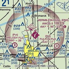
| Sectional chart |
|---|
|
| Airport distance calculator |
|---|
|
|
| Sunrise and sunset |
|---|
|
Times for 15-Jun-2026
| | Local
(UTC-5) | | Zulu
(UTC) |
|---|
| Morning civil twilight | | 04:48 | | 09:48 |
| Sunrise | | 05:21 | | 10:21 |
| Sunset | | 20:20 | | 01:20 |
| Evening civil twilight | | 20:53 | | 01:53 |
|
| Current date and time |
|---|
| Zulu (UTC) | 15-Jun-2026 10:29:16 |
|---|
| Local (UTC-5) | 15-Jun-2026 05:29:16 |
|---|
|
| METAR |
|---|
| KDNV | 151015Z AUTO 00000KT 10SM OVC060 13/12 A3002 RMK AO2 T01300118
|
|
| TAF |
|---|
KLAF
32nm NE | 150527Z 1506/1606 00000KT P6SM SCT050 FM151400 27008KT P6SM FEW050 FM160200 23003KT P6SM SCT250
|
KCMI
32nm W | 150531Z 1506/1606 VRB05KT P6SM SCT060 FM151700 28009KT P6SM SCT050 SCT250 FM160100 24006KT P6SM SCT250
|
|
| NOTAMs |
|---|
NOTAMs are issued by the DoD/FAA and will open in a separate window not controlled by AirNav.
|
|

