FAA INFORMATION EFFECTIVE 06 AUGUST 2026
Location
| FAA Identifier: | E70 |
| Lat/Long: | 29-36-08.6625N 097-59-26.0270W
29-36.144375N 097-59.433783W
29.6024063,-97.9905631
(estimated) |
| Elevation: | 556 ft. / 169 m (estimated) |
| Variation: | 06E (1995) |
| From city: | 2 miles NW of SEGUIN, TX |
| Time zone: | UTC -5 (UTC -6 during Standard Time) |
| Zip code: | 78155 |
Airport Operations
| Airport use: | Open to the public |
| Activation date: | 06/2000 |
| Control tower: | no |
| ARTCC: | HOUSTON CENTER |
| FSS: | SAN ANGELO FLIGHT SERVICE STATION |
| NOTAMs facility: | SJT (NOTAM-D service available) |
| Attendance: | MON-FRI 0800-1700 |
| Wind indicator: | yes |
| Segmented circle: | no |
| Lights: | ACTVT LIRL RWY 18/36 - CTAF. |
| Beacon: | white-green (lighted land airport)
Operates sunset to sunrise. |
Airport Communications
| CTAF: | 122.9 |
| WX ASOS at BAZ (7 nm NW): | 119.325 (830-629-7979) |
| WX AWOS-3PT at HYI (19 nm N): | PHONE 512-353-8005 |
Nearby radio navigation aids
| VOR radial/distance | | VOR name | | Freq | | Var |
|---|
| RNDr067/16.2 | | RANDOLPH VORTAC | | 112.30 | | 05E |
| SATr088/24.7 | | SAN ANTONIO VORTAC | | 116.80 | | 08E |
| SSFr046/(31.4) | | STINSON VOR | | 108.40 | | 03E |
Airport Services
| Fuel available: | 100LL
100LL:FUEL SELF-SERVE. |
Runway Information
Runway 18/36
| Dimensions: | 3415 x 50 ft. / 1041 x 15 m |
| Surface: | asphalt, in good condition |
| Runway edge lights: | low intensity
ONLY CNTR 3285 FT LGTD. |
| RUNWAY 18 | | RUNWAY 36 |
| Latitude: | 29-36.426083N | | 29-35.862667N |
| Longitude: | 097-59.437967W | | 097-59.429600W |
| Elevation: | 556.0 ft. | | 552.0 ft. |
| Traffic pattern: | left | | left |
| Markings: | basic, in good condition | | basic, in good condition |
| Obstructions: | 8 ft. other, 208 ft. from runway, 15 ft. left of centerline, 1:1 slope to clear
18 FT RD, 125 FT DSTC, 125 FT L/R. | | none
RWY 36, 7 FT CROPS 0-199 FT DSTC, ACRS APCH, SEASONAL. |
Airport Ownership and Management from official FAA records
| Ownership: | Privately-owned |
| Owner: | HUBER AIRPARK
2475 RUDELOFF RD
SEGUIN, TX 78155
Phone 830-379-9800 |
| Manager: | DERRICK SMITH
509 BEECHCRAFT LN
SEGUIN, TX 78155
Phone 830-379-9800
OR 619-228-5885 MGR CELL. DERRICK@VERACITYAVIATION.COM |
Additional Remarks
| - | FOR CD CTC SAN ANTONIO APCH AT 210-805-5516. |
| - | 10 FT DITCH PARALLEL TO RWY FULL LENGTH, 125 E OF RWY CL AND ACROSS RWY 36 END, 140 FT DSTC, 125 FT. L/R ACRS APCH. |
Instrument Procedures
There are no published instrument procedures at E70.
Some nearby airports with instrument procedures:
KBAZ - New Braunfels National Airport (7 nm NW)
KRND - Randolph Air Force Base (16 nm W)
KHYI - San Marcos Regional Airport (19 nm N)
50R - Lockhart Municipal Airport (22 nm NE)
KSAT - San Antonio International Airport (25 nm W)
|
|

Road maps at:
MapQuest
Bing
Google
| Aerial photo |
|---|
WARNING: Photo may not be current or correct
 Photo by Kim Demore of Veracity Aviation
Photo taken 15-May-2013
looking northwest.
Photo by Kim Demore of Veracity Aviation
Photo taken 15-May-2013
looking northwest.
Do you have a better or more recent aerial photo of Huber Airpark Civic Club LLC Airport that you would like to share? If so, please send us your photo.
|
| Sectional chart |
|---|
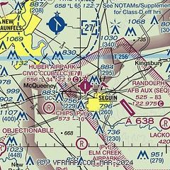
|
| Airport distance calculator |
|---|
|
|
| Sunrise and sunset |
|---|
|
Times for 09-Aug-2026
| | Local
(UTC-5) | | Zulu
(UTC) |
|---|
| Morning civil twilight | | 06:32 | | 11:32 |
| Sunrise | | 06:57 | | 11:57 |
| Sunset | | 20:17 | | 01:17 |
| Evening civil twilight | | 20:43 | | 01:43 |
|
| Current date and time |
|---|
| Zulu (UTC) | 09-Aug-2026 08:49:38 |
|---|
| Local (UTC-5) | 09-Aug-2026 03:49:38 |
|---|
|
| METAR |
|---|
KSEQ
5nm SE | 090800Z AUTO 22004KT 5SM BR CLR 26/24 A2998 RMK AO2 SLP146 $
|
KBAZ
8nm NW | 090834Z AUTO 21006KT 10SM SCT017 25/23 A3001 RMK AO2 T02500233
|
KRND
15nm W | 090755Z AUTO 18003KT 10SM FEW017 26/23 A3003 RMK AO2 SLP159 T02620230 $
|
KHYI
18nm N | 090835Z AUTO 23004KT 10SM OVC015 26/23 A3003 RMK AO2
|
|
| NOTAMs |
|---|
NOTAMs are issued by the DoD/FAA and will open in a separate window not controlled by AirNav.
|
|


