FAA INFORMATION EFFECTIVE 09 JULY 2026
Location
| FAA Identifier: | F46 |
| Lat/Long: | 32-55-50.1400N 096-26-07.7480W
32-55.835667N 096-26.129133W
32.9305944,-96.4354856
(estimated) |
| Elevation: | 574.1 ft. / 175.0 m (surveyed) |
| Variation: | 05E (2000) |
| From city: | 2 miles E of ROCKWALL, TX |
| Time zone: | UTC -5 (UTC -6 during Standard Time) |
| Zip code: | 75087 |
Airport Operations
| Airport use: | Open to the public |
| Activation date: | 11/1962 |
| Control tower: | no |
| ARTCC: | FORT WORTH CENTER |
| FSS: | FORT WORTH FLIGHT SERVICE STATION |
| NOTAMs facility: | F46 (NOTAM-D service available) |
| Attendance: | 0800-DUSK |
| Wind indicator: | yes |
| Segmented circle: | yes |
| Lights: | ACTVT LIRL RWY 17/35 - CTAF. |
| Beacon: | white-green (lighted land airport)
Operates sunset to sunrise. |
Airport Communications
| CTAF/UNICOM: | 122.8 |
| WX AWOS-3PT: | 121.25 (469-991-7392) |
| LONE STAR APPROACH: | 124.3 |
| LONE STAR DEPARTURE: | 124.3 |
| BOTCH DP: | 124.3 |
| EESAT STAR: | 125.025 125.275 |
| FINGR STAR: | 124.3 125.275 |
| GARLAND DP: | 125.2 |
| GREGS STAR: | 118.1 |
| HERBZ STAR: | 118.1 |
| JFRYE STAR: | 118.1 |
| JOE POOL DP: | 125.2 |
| LOADS STAR: | 125.025 125.275 |
| SLANT STAR: | 125.025 125.275 |
| SWVAY STAR: | 135.975 |
| YEAGR STAR: | 125.2 |
| WX AWOS-3 at HQZ (12 nm SW): | 118.175 (972-222-7631) |
| WX ASOS at TRL (16 nm SE): | 119.275 (972-551-1334) |
| WX ASOS at TKI (17 nm NW): | PHONE 972-548-8525 |
Nearby radio navigation aids
| VOR radial/distance | | VOR name | | Freq | | Var |
|---|
| CVEr078/23.7 | | COWBOY VOR/DME | | 116.20 | | 06E |
| TTTr077/30.7 | | MAVERICK VOR/DME | | 113.10 | | 06E |
| FUZr080/37.6 | | RANGER VORTAC | | 115.70 | | 06E |
| BYPr190/37.8 | | BONHAM VORTAC | | 114.60 | | 06E |
Airport Services
| Fuel available: | 100LL JET-A+
100LL:SELF-SVC FUEL. |
| Parking: | tiedowns |
| Airframe service: | MAJOR |
| Powerplant service: | MAJOR |
| Bottled oxygen: | NONE |
| Bulk oxygen: | NONE |
Runway Information
Runway 17/35
| Dimensions: | 3373 x 45 ft. / 1028 x 14 m |
| Surface: | asphalt, in excellent condition |
| Weight bearing capacity: | |
| Runway edge lights: | low intensity |
| RUNWAY 17 | | RUNWAY 35 |
| Latitude: | 32-56.111367N | | 32-55.560067N |
| Longitude: | 096-26.171867W | | 096-26.085283W |
| Elevation: | 559.3 ft. | | 563.1 ft. |
| Traffic pattern: | left | | right |
| Runway heading: | 167 magnetic, 172 true | | 347 magnetic, 352 true |
| Displaced threshold: | 470 ft. | | 289 ft. |
| Markings: | nonprecision, in good condition | | nonprecision, in good condition |
| Touchdown point: | yes, no lights | | yes, no lights |
| Obstructions: | 35 ft. pline, marked and lighted, 430 ft. from runway, 6:1 slope to clear
20 FT TREES, 0-200 FT DSTC, 100 FT R. | | 50 ft. trees, 750 ft. from runway, 340 ft. left and right of centerline, 11:1 slope to clear
15 FT RD, 22 FT DSTC, 250 L/R. |
Airport Ownership and Management from official FAA records
| Ownership: | Publicly-owned |
| Owner: | CITY OF ROCKWALL
385 S. GOLIAD ST.
ROCKWALL, TX 75087
Phone 972-771-7700 |
| Manager: | MELISSA HARDIN
1701 AIRPORT RD.
ROCKWALL, TX 75087
Phone 972-771-0151
AMGR CELL, 972-835-5395. F46AVIATIONSERVICES@GMAIL.COM |
Additional Remarks
| - | NO LINE OF SIGHT BTN RWY ENDS. |
| - | RWY 17 50 FT DROP OFF AT APCH END OF PAVEMENT; STEEP DOWN SLOPE ALL SIDES OF DSPLCMT. |
| - | SVRL AREAS RWY & TXY PAVEMENT LIP GTR THAN 3 INS AT EDGE. |
| - | FOR CD CTC LONE STAR APCH AT 972-615-2799. |
Instrument Procedures
NOTE: All procedures below are presented as PDF files. If you need a reader for these files, you should download the free Adobe Reader.NOT FOR NAVIGATION. Please procure official charts for flight.
FAA instrument procedures published for use from 09 July 2026 at 0901Z to 06 August 2026 at 0900Z.
STARs - Standard Terminal Arrivals |
|---|
| EESAT FOUR (RNAV) **NEW** | |
download (193KB) |
| FINGR ONE **NEW** | |
2 pages:
[1] [2] (428KB) |
| GREGS ONE **NEW** | |
2 pages:
[1] [2] (469KB) |
| HERBZ TWO (RNAV) **NEW** | |
download (281KB) |
| JFRYE FIVE (RNAV) **NEW** | |
download (257KB) |
| LOADS FOUR (RNAV) **NEW** | |
download (194KB) |
| SLANT THREE (RNAV) **NEW** | |
download (254KB) |
| SWVAY FOUR (RNAV) **NEW** | |
download (239KB) |
| YEAGR FOUR **NEW** | |
2 pages:
[1] [2] (631KB) |
IAPs - Instrument Approach Procedures |
|---|
| RNAV (GPS) RWY 17 | |
download (188KB) |
| RNAV (GPS) RWY 35 | |
download (207KB) |
| NOTE: Special Alternate Minimums apply | |
download (117KB) |
Departure Procedures |
|---|
| BOTCH TWO (RNAV) | |
2 pages:
[1] [2] (341KB) |
| GARLAND SIX | |
2 pages:
[1] [2] (311KB) |
| JOE POOL EIGHT | |
2 pages:
[1] [2] (430KB) |
| KINGDOM FIVE | |
2 pages:
[1] [2] (337KB) |
| KUSSO THREE (RNAV) | |
2 pages:
[1] [2] (309KB) |
| NANDR FOUR (RNAV) | |
2 pages:
[1] [2] (315KB) |
| NOTE: Special Take-Off Minimums/Departure Procedures apply | |
download |
Other nearby airports with instrument procedures:
7F3 - Caddo Mills Municipal Airport (12 nm NE)
KHQZ - Mesquite Metro Airport (12 nm SW)
KTRL - Terrell Municipal Airport (16 nm SE)
KTKI - McKinney National Airport (17 nm NW)
KADS - Addison Airport (20 nm W)
|
|

Road maps at:
MapQuest
Bing
Google
| Aerial photo |
|---|
WARNING: Photo may not be current or correct
 Photo taken 16-Jan-2017
looking south.
Photo taken 16-Jan-2017
looking south.
Do you have a better or more recent aerial photo of Ralph M Hall/Rockwall Municipal Airport that you would like to share? If so, please send us your photo.
|
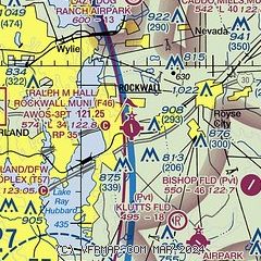
| Sectional chart |
|---|
|
| Airport distance calculator |
|---|
|
|
| Sunrise and sunset |
|---|
|
Times for 21-Jul-2026
| | Local
(UTC-5) | | Zulu
(UTC) |
|---|
| Morning civil twilight | | 06:05 | | 11:05 |
| Sunrise | | 06:33 | | 11:33 |
| Sunset | | 20:31 | | 01:31 |
| Evening civil twilight | | 20:59 | | 01:59 |
|
| Current date and time |
|---|
| Zulu (UTC) | 22-Jul-2026 00:04:53 |
|---|
| Local (UTC-5) | 21-Jul-2026 19:04:53 |
|---|
|
| METAR |
|---|
| KF46 | 212355Z AUTO 00000KT 10SM CLR 38/21 A2986 RMK AO2 T03790211 10383 20357
|
KHQZ
12nm SW | 212350Z 00000KT 10SM CLR 41/18 A2985
|
KTRL
15nm SE | 212353Z AUTO VRB05KT 10SM CLR 38/19 A2985 RMK AO2 SLP099 T03830194 10394 20367 55006
|
KTKI
17nm NW | 212353Z 12004KT 10SM CLR 37/23 A2985 RMK AO2 SLP099 T03670233 10389 20367 56006
|
KADS
19nm W | 212347Z 11009KT 10SM SKC 39/18 A2986
|
|
| TAF |
|---|
KDAL
21nm W | 212045Z 2121/2218 VRB05KT P6SM SCT070 FM220200 18005KT P6SM FEW250 FM221200 01005KT P6SM FEW250
|
|
| NOTAMs |
|---|
NOTAMs are issued by the DoD/FAA and will open in a separate window not controlled by AirNav.
|
|


