FAA INFORMATION EFFECTIVE 27 NOVEMBER 2025
Location
| FAA Identifier: | F78 |
| Lat/Long: | 32-34-22.4840N 097-52-21.1220W
32-34.374733N 097-52.352033W
32.5729122,-97.8725339
(estimated) |
| Elevation: | 715 ft. / 218 m (estimated) |
| Variation: | 07E (1985) |
| From city: | 12 miles SW of WEATHERFORD, TX |
| Time zone: | UTC -6 (UTC -5 during Daylight Saving Time) |
| Zip code: | 76087 |
Airport Operations
| Airport use: | Open to the public |
| Activation date: | 08/1976 |
| Control tower: | no |
| ARTCC: | FORT WORTH CENTER |
| FSS: | FORT WORTH FLIGHT SERVICE STATION |
| NOTAMs facility: | FTW (NOTAM-D service available) |
| Attendance: | UNATNDD |
| Wind indicator: | yes |
| Segmented circle: | no |
Airport Communications
| CTAF: | 122.9 |
| WX AWOS-3T at GDJ (8 nm S): | 118.925 (817-573-7514) |
| WX ASOS at MWL (16 nm NW): | 135.075 (940-325-2457) |
Nearby radio navigation aids
| VOR radial/distance | | VOR name | | Freq | | Var |
|---|
| MQPr137/11.2 | | MILLSAP VORTAC | | 117.70 | | 09E |
| FUZr236/39.8 | | RANGER VORTAC | | 115.70 | | 06E |
Airport Services
Runway Information
Runway 17/35
| Dimensions: | 3000 x 30 ft. / 914 x 9 m |
| Surface: | turf, in fair condition |
| RUNWAY 17 | | RUNWAY 35 |
| Traffic pattern: | left | | left |
| Obstructions: | 30 ft. pole, 160 ft. from runway, 52 ft. left of centerline, 5:1 slope to clear
ALSO 4 FT FENCE & 6 FT BRUSH, 0 FT DSTC, 100 FT R, APCH SLOPE 0:1. | | 44 ft. tree, 100 ft. right of centerline |
Airport Ownership and Management from official FAA records
| Ownership: | Privately-owned |
| Owner: | HORSESHOE BEND AIRPARK OWNERS, LLC
1232 WILDFLOWER LN
MESQUITE, TX 75149
Phone 214-460-4332
ARPT PHYS ADS: 128 PIPER TRAIL, WEATHERFORD, TX |
| Manager: | DOC MIRROR, MANAGER
128 PIPER TRL
WEATHERFORD, TX 76087
Phone 817-886-2256 |
Additional Remarks
| - | DEER AND MOTOR VEHICLES ON RWY. |
| - | FOR CD CTC FORT WORTH ARTCC AT 817-858-7584. |
| - | RWY 17 27 FT POLE, 158 FT DSTC, 54 FT L. |
Instrument Procedures
There are no published instrument procedures at F78.
Some nearby airports with instrument procedures:
KGDJ - Granbury Regional Airport (8 nm S)
KWEA - Parker County Airport (14 nm NE)
50F - Bourland Field Airport (14 nm E)
KMWL - Mineral Wells Regional Airport (16 nm NW)
KNFW - Fort Worth Naval Air Station JRB (Carswell Field) Airport (25 nm NE)
|
|

Road maps at:
MapQuest
Bing
Google
| Aerial photo |
|---|
WARNING: Photo may not be current or correct

Do you have a better or more recent aerial photo of Horseshoe Bend Airport that you would like to share? If so, please send us your photo.
|
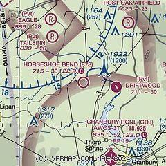
| Sectional chart |
|---|
|
| Airport distance calculator |
|---|
|
|
| Sunrise and sunset |
|---|
|
Times for 05-Dec-2025
| | Local
(UTC-6) | | Zulu
(UTC) |
|---|
| Morning civil twilight | | 06:53 | | 12:53 |
| Sunrise | | 07:20 | | 13:20 |
| Sunset | | 17:25 | | 23:25 |
| Evening civil twilight | | 17:51 | | 23:51 |
|
| Current date and time |
|---|
| Zulu (UTC) | 05-Dec-2025 09:40:43 |
|---|
| Local (UTC-6) | 05-Dec-2025 03:40:43 |
|---|
|
| METAR |
|---|
KGDJ
8nm S | AWOS-3 118.925 817-573-7514
050855Z AUTO 00000KT 02/01 A3018 RMK AO2 T00200010 PWINO
|
KMWL
16nm NW | 050853Z AUTO 14005KT 3SM BR CLR 01/00 A3014 RMK AO2 SLP208 T00060000 58019
|
|
| TAF |
|---|
KNFW
24nm NE | 0507/0607 VRB06KT 9999 FEW020 SCT060 BKN250 QNH3000INS AUTOMATED SENSOR METWATCH 0507 TIL 0512 TX12/0518Z TN08/0512Z FN00290
|
KFTW
30nm NE | 050520Z 0506/0606 00000KT P6SM OVC013 FM050900 VRB03KT P6SM SCT013 OVC180 FM051200 18007KT P6SM BKN180
|
|
| NOTAMs |
|---|
NOTAMs are issued by the DoD/FAA and will open in a separate window not controlled by AirNav.
|
|


