FAA INFORMATION EFFECTIVE 14 MAY 2026
Location
| FAA Identifier: | FDY |
| Lat/Long: | 41-00-43.3000N 083-40-07.0000W
41-00.721667N 083-40.116667W
41.0120278,-83.6686111
(estimated) |
| Elevation: | 812.8 ft. / 247.7 m (surveyed) |
| Variation: | 05W (1985) |
| From city: | 2 miles SSW of FINDLAY, OH |
| Time zone: | UTC -4 (UTC -5 during Standard Time) |
| Zip code: | 45840 |
Airport Operations
| Airport use: | Open to the public |
| Activation date: | 10/1937 |
| Control tower: | no |
| ARTCC: | CLEVELAND CENTER |
| FSS: | CLEVELAND FLIGHT SERVICE STATION |
| NOTAMs facility: | FDY (NOTAM-D service available) |
| Attendance: | MON-FRI 0700-1800, ALL SAT-SUN 0900-1700 |
| Wind indicator: | lighted |
| Segmented circle: | no |
| Lights: | ACTVT REIL RWY 07, 25, & 36; PAPI RWY 07, 25, 18, & 36; MIRL RWY 07/25; HIRL RWY 18/36 - CTAF. PAPI RWY 07, 25, 18, & 36 OPR CONSLY SR-SS. |
| Beacon: | white-green (lighted land airport)
Operates sunset to sunrise. |
| Landing fee: | yes |
Airport Communications
| CTAF/UNICOM: | 122.725 |
| WX ASOS: | 132.85 (419-427-8524) |
| TOLEDO APPROACH: | 120.8 |
| TOLEDO DEPARTURE: | 120.8 |
| WX AWOS-3 at OWX (14 nm W): | 120.525 (419-523-4151) |
| WX AWOS-3 at FZI (16 nm NE): | 124.625 (419-436-0053) |
Nearby radio navigation aids
| VOR radial/distance | | VOR name | | Freq | | Var |
|---|
| FBCr051/5.2 | | FLAG CITY VORTAC | | 108.20 | | 02W |
| BUDr316/(36.3) | | BUCKEYE VOR | | 109.80 | | 05W |
| NDB name | | Hdg/Dist | | Freq | | Var | | ID |
|---|
| TIFFIN | | 261/21.1 | | 269 | | 05W | | TII | - .. .. |
Airport Services
| Fuel available: | 100LL JET-A+ |
| Parking: | hangars and tiedowns |
| Airframe service: | NONE |
| Powerplant service: | NONE |
| Bottled oxygen: | NONE |
| Bulk oxygen: | NONE |
Runway Information
Runway 18/36
| Dimensions: | 6499 x 100 ft. / 1981 x 30 m |
| Surface: | asphalt/grooved, in good condition |
| Weight bearing capacity: | | Single wheel: | 100.0 | | Double wheel: | 160.0 | | Double tandem: | 280.0 |
|
| Runway edge lights: | high intensity |
| RUNWAY 18 | | RUNWAY 36 |
| Latitude: | 41-01.130793N | | 41-00.060635N |
| Longitude: | 083-39.968195W | | 083-39.976007W |
| Elevation: | 804.5 ft. | | 803.2 ft. |
| Traffic pattern: | left | | left |
| Runway heading: | 185 magnetic, 180 true | | 005 magnetic, 000 true |
| Markings: | nonprecision, in fair condition | | nonprecision, in fair condition |
| Visual slope indicator: | 4-light PAPI on left (3.00 degrees glide path) | | 4-light PAPI on left (3.00 degrees glide path) |
| Runway end identifier lights: | no | | yes |
| Touchdown point: | yes, no lights | | yes, no lights |
Runway 7/25
| Dimensions: | 5883 x 100 ft. / 1793 x 30 m |
| Surface: | asphalt/grooved, in fair condition |
| Weight bearing capacity: | | Single wheel: | 100.0 | | Double wheel: | 160.0 | | Double tandem: | 280.0 |
|
| Runway edge lights: | medium intensity |
| RUNWAY 7 | | RUNWAY 25 |
| Latitude: | 41-00.684613N | | 41-01.036975N |
| Longitude: | 083-40.870985W | | 083-39.679535W |
| Elevation: | 793.7 ft. | | 805.8 ft. |
| Traffic pattern: | left | | left |
| Runway heading: | 074 magnetic, 069 true | | 254 magnetic, 249 true |
| Displaced threshold: | 324 ft. | | 999 ft. |
| Declared distances: | TORA:5251 TODA:5251 ASDA:4881 LDA:4558 | | TORA:5786 TODA:5786 ASDA:5558 LDA:4558 |
| Markings: | nonprecision, in good condition | | nonprecision, in good condition |
| Visual slope indicator: | 4-light PAPI on left (3.00 degrees glide path) | | 4-light PAPI on left (3.00 degrees glide path) |
| Runway end identifier lights: | yes | | yes |
| Touchdown point: | yes, no lights | | yes, no lights |
| Obstructions: | 79 ft. trees, 2350 ft. from runway, 559 ft. left of centerline, 27:1 slope to clear
APCH SLP 17:1 TO DTHR OVR 65 FT TREES, 1108 FT DIST, 392 FT L. | | 21 ft. road, lighted, 201 ft. from runway, 250 ft. left and right of centerline
12 FT L/M BLAST FENCE, 117 FT DIST; 18 FT ROAD, 110 FT DIST. |
Airport Ownership and Management from official FAA records
| Ownership: | Publicly-owned |
| Owner: | CITY OF FINDLAY
310 MUNICIPAL BLDG
FINDLAY, OH 45840-3346
Phone 419-424-7137 |
| Manager: | AMANDA MCGEE
1205 LIMA AVE
FINDLAY, OH 45840-1472
Phone 419-422-4182 |
Additional Remarks
| - | FOR CD IF UNA TO CTC ON FSS FREQ, CTC TOLEDO APCH AT 419-865-1495. |
| - | BIRDS & WILDLIFE ON & INVOF ARPT. |
Instrument Procedures
NOTE: All procedures below are presented as PDF files. If you need a reader for these files, you should download the free Adobe Reader.NOT FOR NAVIGATION. Please procure official charts for flight.
FAA instrument procedures published for use from 14 May 2026 at 0901Z to 11 June 2026 at 0900Z.
IAPs - Instrument Approach Procedures |
|---|
| RNAV (GPS) RWY 07 | |
download (233KB) |
| RNAV (GPS) RWY 18 | |
download (221KB) |
| RNAV (GPS) RWY 25 | |
download (222KB) |
| RNAV (GPS) RWY 36 | |
download (249KB) |
| NOTE: Special Alternate Minimums apply **CHANGED** | |
download (150KB) |
| NOTE: Special Take-Off Minimums/Departure Procedures apply | |
download (344KB) |
Other nearby airports with instrument procedures:
5G7 - Bluffton Airport (12 nm SW)
KOWX - Putnam County Airport (14 nm W)
KFZI - Donald P Miller Airport (16 nm NE)
56D - Wyandot County Airport (18 nm SE)
16G - Seneca County Airport (21 nm E)
|
|

Road maps at:
MapQuest
Bing
Google
| Aerial photo |
|---|
WARNING: Photo may not be current or correct
 Photo courtesy of AirNav, LLC
Photo taken 21-Jul-2010
Photo courtesy of AirNav, LLC
Photo taken 21-Jul-2010
Do you have a better or more recent aerial photo of Findlay Airport that you would like to share? If so, please send us your photo.
|
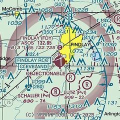
| Sectional chart |
|---|
|
| Airport distance calculator |
|---|
|
|
| Sunrise and sunset |
|---|
|
Times for 01-Jun-2026
| | Local
(UTC-4) | | Zulu
(UTC) |
|---|
| Morning civil twilight | | 05:33 | | 09:33 |
| Sunrise | | 06:06 | | 10:06 |
| Sunset | | 20:59 | | 00:59 |
| Evening civil twilight | | 21:32 | | 01:32 |
|
| Current date and time |
|---|
| Zulu (UTC) | 01-Jun-2026 17:24:40 |
|---|
| Local (UTC-4) | 01-Jun-2026 13:24:40 |
|---|
|
| METAR |
|---|
| KFDY | 011653Z AUTO 07004KT 10SM CLR 22/04 A3005 RMK AO2 SLP170 T02220044
|
KOWX
14nm W | 011655Z AUTO 06007KT 10SM CLR 24/07 A3008 RMK AO2
|
|
| TAF |
|---|
| KFDY | 011120Z 0112/0212 VRB02KT P6SM SCT250 FM011600 07010KT P6SM SCT250 FM020200 04004KT P6SM FEW250
|
|
| NOTAMs |
|---|
NOTAMs are issued by the DoD/FAA and will open in a separate window not controlled by AirNav.
|
|


