FAA INFORMATION EFFECTIVE 11 JUNE 2026
Location
| FAA Identifier: | GYB |
| Lat/Long: | 30-10-09.4000N 096-58-48.1000W
30-10.156667N 096-58.801667W
30.1692778,-96.9800278
(estimated) |
| Elevation: | 484.1 ft. / 147.6 m (surveyed) |
| Variation: | 06E (2000) |
| From city: | 3 miles W of GIDDINGS, TX |
| Time zone: | UTC -5 (UTC -6 during Standard Time) |
| Zip code: | 78942 |
Airport Operations
| Airport use: | Open to the public |
| Activation date: | 09/1971 |
| Control tower: | no |
| ARTCC: | HOUSTON CENTER |
| FSS: | MONTGOMERY COUNTY FLIGHT SERVICE STATION |
| NOTAMs facility: | GYB (NOTAM-D service available) |
| Attendance: | MON-FRI 0800-1700 |
| Wind indicator: | lighted |
| Segmented circle: | yes |
| Lights: | SS-SR |
| Beacon: | white-green (lighted land airport)
Operates sunset to sunrise. |
Airport Communications
| CTAF/UNICOM: | 123.05 |
| WX AWOS-3: | 119.225 (979-542-0382) |
| AUSTIN APPROACH: | 127.225 |
| AUSTIN DEPARTURE: | 127.225 |
| WX AWOS-3 at 3T5 (16 nm S): | 124.175 (979-242-5777) |
Nearby radio navigation aids
| VOR radial/distance | | VOR name | | Freq | | Var |
|---|
| CWKr108/31.1 | | CENTEX VORTAC | | 112.80 | | 06E |
| CLLr220/39.0 | | COLLEGE STATION VORTAC | | 113.30 | | 08E |
Airport Services
| Fuel available: | 100LL JET-A
100LL:100LL & JET A 24 HR SELF SERVE. |
| Parking: | tiedowns |
| Airframe service: | MAJOR |
| Powerplant service: | MAJOR |
| Bottled oxygen: | NONE |
| Bulk oxygen: | NONE |
Runway Information
Runway 17/35
| Dimensions: | 4000 x 75 ft. / 1219 x 23 m |
| Surface: | asphalt, in good condition |
| Weight bearing capacity: | |
| Runway edge lights: | medium intensity |
| RUNWAY 17 | | RUNWAY 35 |
| Latitude: | 30-10.484307N | | 30-09.827748N |
| Longitude: | 096-58.839007W | | 096-58.763177W |
| Elevation: | 484.1 ft. | | 439.1 ft. |
| Traffic pattern: | left | | left |
| Runway heading: | 168 magnetic, 174 true | | 348 magnetic, 354 true |
| Markings: | nonprecision, in good condition | | nonprecision, in good condition |
| Visual slope indicator: | 2-light PAPI on left (3.75 degrees glide path) | | 2-light PAPI on left (3.40 degrees glide path) |
| Touchdown point: | yes, no lights | | yes, no lights |
| Obstructions: | 44 ft. trees, 520 ft. from runway, 260 ft. left of centerline, 7:1 slope to clear
5 FT FENCE, 0-77 FT DSTC, 222 FT L. | | 45 ft. trees, 320 ft. from runway, 256 ft. left of centerline, 2:1 slope to clear |
Airport Ownership and Management from official FAA records
| Ownership: | Publicly-owned |
| Owner: | CITY OF GIDDINGS & LEE CO
118 E RICHMOND
GIDDINGS, TX 78942
Phone 979-540-2710 |
| Manager: | KYLE WEISS
1234 CR 206
GIDDINGS, TX 78942
Phone 979-542-6081 |
Additional Remarks
| - | DEER ON & INVOF ARPT. |
| - | FOR CD CTC AUSTIN APCH AT 512-369-7865. |
Instrument Procedures
NOTE: All procedures below are presented as PDF files. If you need a reader for these files, you should download the free Adobe Reader.NOT FOR NAVIGATION. Please procure official charts for flight.
FAA instrument procedures published for use from 11 June 2026 at 0901Z to 09 July 2026 at 0900z.
IAPs - Instrument Approach Procedures |
|---|
| RNAV (GPS) RWY 17 | |
download (221KB) |
| RNAV (GPS) RWY 35 | |
download (205KB) |
| NOTE: Special Alternate Minimums apply | |
download (126KB) |
| NOTE: Special Take-Off Minimums/Departure Procedures apply | |
download (70KB) |
Other nearby airports with instrument procedures:
84R - Smithville Crawford Municipal Airport (13 nm SW)
3T5 - Fayette Regional Air Center Airport (16 nm S)
KRWV - Caldwell Municipal Airport (25 nm NE)
11R - Brenham Municipal Airport (32 nm E)
KEDC - Austin Executive Airport (33 nm NW)
|
|

Road maps at:
MapQuest
Bing
Google
| Aerial photo |
|---|
WARNING: Photo may not be current or correct
 Photo taken 11-Nov-2007
Do you have a better or more recent aerial photo of Giddings-Lee County Airport that you would like to share? If so, please send us your photo.
|
| Sectional chart |
|---|
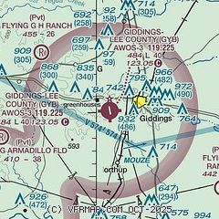
|
| Airport distance calculator |
|---|
|
|
| Sunrise and sunset |
|---|
|
Times for 22-Jun-2026
| | Local
(UTC-5) | | Zulu
(UTC) |
|---|
| Morning civil twilight | | 06:01 | | 11:01 |
| Sunrise | | 06:28 | | 11:28 |
| Sunset | | 20:32 | | 01:32 |
| Evening civil twilight | | 20:59 | | 01:59 |
|
| Current date and time |
|---|
| Zulu (UTC) | 22-Jun-2026 22:02:30 |
|---|
| Local (UTC-5) | 22-Jun-2026 17:02:30 |
|---|
|
| METAR |
|---|
| KGYB | 222155Z AUTO 19011G18KT 10SM BKN044 34/23 A2998 RMK AO2 T03360229
|
K3T5
16nm S | 222155Z AUTO 18011G18KT 10SM SCT044 34/23 A2995 RMK AO2 T03400231 $
|
|
| TAF |
|---|
KAUS
38nm W | 221720Z 2218/2324 16014G24KT P6SM SCT035 FM230100 16012KT P6SM FEW050 FM230500 17008KT P6SM OVC015 FM231600 17008G18KT P6SM SCT030
|
KCLL
40nm NE | 221720Z 2218/2318 19010G20KT P6SM FEW045 FM230100 17007KT P6SM FEW030 SCT250 FM230500 18004KT P6SM BKN015 BKN025 FM231600 19010KT P6SM BKN040
|
|
| NOTAMs |
|---|
NOTAMs are issued by the DoD/FAA and will open in a separate window not controlled by AirNav.
|
|

