FAA INFORMATION EFFECTIVE 12 JUNE 2025
Location
| FAA Identifier: | AAF |
| Lat/Long: | 29-43-39.1780N 085-01-38.5590W
29-43.652967N 085-01.642650W
29.7275494,-85.0273775
(estimated) |
| Elevation: | 19.6 ft. / 6.0 m (surveyed) |
| Variation: | 03W (2010) |
| From city: | 2 miles W of APALACHICOLA, FL |
| Time zone: | UTC -4 (UTC -5 during Standard Time) |
| Zip code: | 32320 |
Airport Operations
| Airport use: | Open to the public |
| Activation date: | 02/1944 |
| Control tower: | no |
| ARTCC: | JACKSONVILLE CENTER |
| FSS: | GAINESVILLE FLIGHT SERVICE STATION |
| NOTAMs facility: | AAF (NOTAM-D service available) |
| Attendance: | 0800-1900 |
| Wind indicator: | lighted |
| Segmented circle: | no |
| Lights: | ACTVT PAPI RWY 6, 24, 14, & 32; MIRL RWY 06/24 & 14/32 - CTAF. |
| Beacon: | white-green (lighted land airport)
Operates sunset to sunrise. |
| Landing fee: | yes |
Airport Communications
| CTAF/UNICOM: | 122.8 |
| WX ASOS: | 119.925 (850-203-0001) |
| TYNDALL APPROACH: | 124.15 ;ABV 5000 FT 125.2 ;ABV 5000 FT |
| TYNDALL DEPARTURE: | 124.15 ;ABV 5000 FT 125.2 ;ABV 5000 FT |
| IC: | 124.15 ;ABV 5000 FT |
- APCH/DEP SVC PRVDD BY JACKSONVILLE ARTCC ON FREQS 120.825/379.3 (PANAMA CITY RCAG) WHEN TYNDALL APCH CTL IS CLSD.
Airport Services
| Fuel available: | 100LL JET-A |
| Parking: | hangars and tiedowns |
| Airframe service: | MAJOR |
| Powerplant service: | MAJOR |
| Bottled oxygen: | NONE |
| Bulk oxygen: | NONE |
Runway Information
Runway 14/32
| Dimensions: | 5425 x 150 ft. / 1654 x 46 m |
| Surface: | concrete, in fair condition |
| Weight bearing capacity: | |
| Runway edge lights: | medium intensity |
| RUNWAY 14 | | RUNWAY 32 |
| Latitude: | 29-43.967343N | | 29-43.331012N |
| Longitude: | 085-02.084767W | | 085-01.363653W |
| Elevation: | 15.1 ft. | | 18.2 ft. |
| Traffic pattern: | left | | left |
| Runway heading: | 138 magnetic, 135 true | | 318 magnetic, 315 true |
| Markings: | nonprecision, in fair condition | | nonprecision, in fair condition |
| Visual slope indicator: | 2-light PAPI on left (3.00 degrees glide path) | | 2-light PAPI on left (3.00 degrees glide path) |
| Touchdown point: | yes, no lights | | yes, no lights |
| Obstructions: | 23 ft. trees, 975 ft. from runway, 20 ft. right of centerline, 34:1 slope to clear | | none |
Runway 6/24
| Dimensions: | 5271 x 150 ft. / 1607 x 46 m |
| Surface: | concrete, in fair condition |
| Weight bearing capacity: | |
| Runway edge lights: | medium intensity |
| RUNWAY 6 | | RUNWAY 24 |
| Latitude: | 29-43.341172N | | 29-43.772248N |
| Longitude: | 085-02.245495W | | 085-01.380173W |
| Elevation: | 19.4 ft. | | 19.3 ft. |
| Traffic pattern: | left | | left |
| Runway heading: | 063 magnetic, 060 true | | 243 magnetic, 240 true |
| Displaced threshold: | no | | 217 ft. |
| Markings: | nonprecision, in fair condition | | nonprecision, in fair condition |
| Visual slope indicator: | 2-light PAPI on left (3.00 degrees glide path) | | 2-light PAPI on left (3.00 degrees glide path) |
| Touchdown point: | yes, no lights | | yes, no lights |
| Obstructions: | 59 ft. trees, 1390 ft. from runway, 185 ft. right of centerline, 20:1 slope to clear | | 45 ft. trees, 880 ft. from runway, 215 ft. left of centerline, 15:1 slope to clear |
Runway 18/36
| Dimensions: | 5251 x 150 ft. / 1601 x 46 m |
| Surface: | concrete, in fair condition |
| Weight bearing capacity: | |
| RUNWAY 18 | | RUNWAY 36 |
| Latitude: | 29-44.186603N | | 29-43.320318N |
| Longitude: | 085-01.384803W | | 085-01.390250W |
| Elevation: | 15.1 ft. | | 19.5 ft. |
| Traffic pattern: | left | | left |
| Runway heading: | 183 magnetic, 180 true | | 003 magnetic, 000 true |
| Displaced threshold: | no | | 502 ft. |
| Markings: | basic, in fair condition | | basic, in fair condition |
| Touchdown point: | yes, no lights | | yes, no lights |
| Obstructions: | 66 ft. trees, 1200 ft. from runway, 250 ft. left of centerline, 15:1 slope to clear
RWY 18 APCH RATIO 20:1 TO AER. | | 41 ft. trees, 515 ft. from runway, 200 ft. left of centerline, 7:1 slope to clear
RWY 36 APCH RATIO TO THE DTHR IS 25:1. |
Airport Ownership and Management from official FAA records
| Ownership: | Publicly-owned |
| Owner: | FRANKLIN COUNTY
33 MARKET STREET, SUITE 203
APALACHICOLA, FL 32320-2317
Phone 850-653-9783 |
| Manager: | STEVE KIRSCHENBAUM
8 AIRPORT ROAD
APALACHICOLA, FL 32320-2317
Phone 850-290-8282 |
Additional Remarks
| A30A-18 | UNLGTD OBSTNS IN APCH; 67 FT TREES 1200 FT BFR AER. |
| A30A-24 | UNLGTD OBSTNS IN APCH; 47 FT TREES 985 FT BFR AER. |
| A30A-06 | UNLGTD OBSTNS IN APCH; 60 FT TREES 1390 FT BFR AER. |
| - | FOR CD CTC TYNDALL APCH AT 850-283-2900 OR 850-283-3353, WHEN APCH CLSD CTC JACKSONVILLE ARTCC AT 904-845-1592. |
Instrument Procedures
NOTE: All procedures below are presented as PDF files. If you need a reader for these files, you should download the free Adobe Reader.NOT FOR NAVIGATION. Please procure official charts for flight.
FAA instrument procedures published for use from 12 June 2025 at 0901Z to 10 July 2025 at 0900z.
IAPs - Instrument Approach Procedures |
|---|
| RNAV (GPS) RWY 06 | |
download (255KB) |
| RNAV (GPS) RWY 14 | |
download (276KB) |
| RNAV (GPS) RWY 24 | |
download (270KB) |
| RNAV (GPS) RWY 32 | |
download (314KB) |
| NOTE: Special Alternate Minimums apply | |
download (124KB) |
| NOTE: Special Take-Off Minimums/Departure Procedures apply | |
download (400KB) |
Other nearby airports with instrument procedures:
KPAM - Tyndall Air Force Base (35 nm NW)
KTLH - Tallahassee International Airport (53 nm NE)
KECP - Northwest Florida Beaches International Airport (55 nm NW)
2J9 - Quincy Municipal Airport (58 nm NE)
KMAI - Marianna Municipal Airport (67 nm N)
|
|

Road maps at:
MapQuest
Bing
Google
| Aerial photo |
|---|
WARNING: Photo may not be current or correct

Do you have a better or more recent aerial photo of Apalachicola Regional Airport-Cleve Randolph Field that you would like to share? If so, please send us your photo.
|
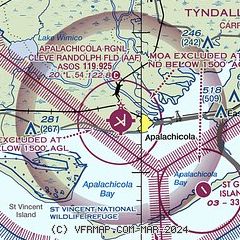
| Sectional chart |
|---|
|
CAUTION: Diagram may not be current

| Airport distance calculator |
|---|
|
|
| Sunrise and sunset |
|---|
|
Times for 01-Jul-2025
| | Local
(UTC-4) | | Zulu
(UTC) |
|---|
| Morning civil twilight | | 06:17 | | 10:17 |
| Sunrise | | 06:44 | | 10:44 |
| Sunset | | 20:44 | | 00:44 |
| Evening civil twilight | | 21:11 | | 01:11 |
|
| Current date and time |
|---|
| Zulu (UTC) | 01-Jul-2025 06:39:27 |
|---|
| Local (UTC-4) | 01-Jul-2025 02:39:27 |
|---|
|
| METAR |
|---|
| KAAF | 010613Z AUTO 33011G20KT 1SM +TSRA BR VV017 24/23 A3003 RMK AO2 LTG DSNT SE TSB0555 P0070 T02390233
|
|
| TAF |
|---|
KPAM
35nm NW | 010300Z 0103/0209 30009KT 9999 SCT025 QNH2999INS TEMPO 0103/0106 VRB12G18KT 8000 -TSRA BKN020CB BECMG 0109/0110 06006KT 9999 BKN020 QNH3001INS TEMPO 0111/0113 03012G18KT 8000 -SHRA VCTS BKN010CB BECMG 0116/0117 26009KT 9999 BKN020 QNH2993INS TEMPO 0118/0122 VRB10G18KT 8000 -TSRA BKN015CB TEMPO 0206/0209 VRB12G18KT 6000 -TSRA BKN015CB TX30/0119Z TN23/0111Z
|
|
| NOTAMs |
|---|
NOTAMs are issued by the DoD/FAA and will open in a separate window not controlled by AirNav.
|
|


