FAA INFORMATION EFFECTIVE 27 NOVEMBER 2025
Location
| FAA Identifier: | AQO |
| Lat/Long: | 30-47-03.2000N 098-39-35.6000W
30-47.053333N 098-39.593333W
30.7842222,-98.6598889
(estimated) |
| Elevation: | 1101.7 ft. / 335.8 m (surveyed) |
| Variation: | 05E (2010) |
| From city: | 2 miles NE of LLANO, TX |
| Time zone: | UTC -6 (UTC -5 during Daylight Saving Time) |
| Zip code: | 78643 |
Airport Operations
| Airport use: | Open to the public |
| Activation date: | 04/1944 |
| Control tower: | no |
| ARTCC: | HOUSTON CENTER |
| FSS: | SAN ANGELO FLIGHT SERVICE STATION |
| NOTAMs facility: | AQO (NOTAM-D service available) |
| Attendance: | FRI-MON 0800-1700, ALL TUE-THU 0700-1700 |
| Wind indicator: | lighted |
| Segmented circle: | yes |
| Lights: | DUSK-DAWN. MIRL RWY 17/35 PRESET LOW INTST; TO INCR INTST ACTVT - CTAF. |
| Beacon: | white-green (lighted land airport)
Operates sunset to sunrise. |
Airport Communications
| CTAF/UNICOM: | 123.05 |
| WX AWOS-3: | 119.425 (325-247-2189) |
- APCH/DEP CTL SVC PRVDD BY HOUSTON ARTCC (ZHU) ON FREQS 132.35/317.5 (LOMETA RCAG).
Nearby radio navigation aids
| VOR radial/distance | | VOR name | | Freq | | Var |
|---|
| STVr356/34.7 | | STONEWALL VORTAC | | 113.80 | | 08E |
| AGJr223/35.9 | | GOOCH SPRINGS VORTAC | | 112.50 | | 05E |
Airport Services
| Fuel available: | 100LL JET-A
100LL:100LL SELF SVC. |
| Parking: | hangars and tiedowns |
| Airframe service: | MAJOR |
| Powerplant service: | MAJOR |
| Bottled oxygen: | NONE |
| Bulk oxygen: | NONE |
Runway Information
Runway 17/35
| Dimensions: | 4202 x 75 ft. / 1281 x 23 m |
| Surface: | asphalt, in good condition |
| Weight bearing capacity: | |
| Runway edge lights: | medium intensity |
| RUNWAY 17 | | RUNWAY 35 |
| Latitude: | 30-47.370402N | | 30-46.677407N |
| Longitude: | 098-39.727282W | | 098-39.716378W |
| Elevation: | 1101.3 ft. | | 1101.5 ft. |
| Traffic pattern: | right | | left |
| Runway heading: | 174 magnetic, 179 true | | 354 magnetic, 359 true |
| Markings: | nonprecision, in good condition | | nonprecision, in good condition |
| Visual slope indicator: | 2-light PAPI on left (2.75 degrees glide path) | | 2-light PAPI on left (2.75 degrees glide path) |
| Touchdown point: | yes, no lights | | yes, no lights |
| Obstructions: | 25 ft. trees, 470 ft. from runway, 295 ft. right of centerline, 10:1 slope to clear | | 15 ft. brush, 278 ft. from runway, 80 ft. left and right of centerline, 5:1 slope to clear
12 FT BRUSH, 50-199 FT DSTC. |
Runway 13/31
| Dimensions: | 3209 x 150 ft. / 978 x 46 m |
| Surface: | turf, in good condition |
| Runway edge markings: | RWY 13/31 THRS MKD WITH WHITE TIRES. |
| RUNWAY 13 | | RUNWAY 31 |
| Latitude: | 30-47.288890N | | 30-46.895650N |
| Longitude: | 098-39.629033W | | 098-39.218767W |
| Elevation: | 1096.0 ft. | | 1076.2 ft. |
| Traffic pattern: | left | | right |
| Runway heading: | 133 magnetic, 138 true | | 313 magnetic, 318 true |
| Touchdown point: | yes, no lights | | yes, no lights |
| Obstructions: | none | | 20 ft. trees, 313 ft. from runway, 120 ft. left of centerline, 15:1 slope to clear |
Airport Ownership and Management from official FAA records
| Ownership: | Publicly-owned |
| Owner: | CITY OF LLANO
301 W MAIN
LLANO, TX 78643
Phone 325-247-4158 |
| Manager: | KIRK D. NOAKER, SR.
100 EVELYN GOULD DRIVE
LLANO, TX 78643
Phone 325-247-5635 |
Additional Remarks
| - | DEER ON & INVOF RWY. |
| - | FOR CD CTC HOUSTON ARTCC AT 281-230-5622. |
Instrument Procedures
NOTE: All procedures below are presented as PDF files. If you need a reader for these files, you should download the free Adobe Reader.NOT FOR NAVIGATION. Please procure official charts for flight.
FAA instrument procedures published for use from 27 November 2025 at 0901Z to 25 December 2025 at 0900Z.
IAPs - Instrument Approach Procedures |
|---|
| RNAV (GPS) RWY 17 | |
download (166KB) |
| RNAV (GPS) RWY 35 | |
download (198KB) |
| NOTE: Special Alternate Minimums apply | |
download (138KB) |
| NOTE: Special Take-Off Minimums/Departure Procedures apply | |
download (308KB) |
Other nearby airports with instrument procedures:
KBMQ - Burnet Municipal Airport/Kate Craddock Field (22 nm E)
T92 - Mason County Airport (27 nm W)
81R - San Saba County Municipal Airport (27 nm N)
KLZZ - Lampasas Airport (31 nm NE)
T82 - Gillespie County Airport (35 nm S)
|
|

Road maps at:
MapQuest
Bing
Google
| Aerial photo |
|---|
WARNING: Photo may not be current or correct
 Photo by Charlie Thompson
Taken in June 2009
Photo by Charlie Thompson
Taken in June 2009
Do you have a better or more recent aerial photo of Llano Municipal Airport that you would like to share? If so, please send us your photo.
|
| Sectional chart |
|---|
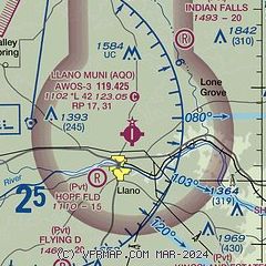
|
| Airport distance calculator |
|---|
|
|
| Sunrise and sunset |
|---|
|
Times for 05-Dec-2025
| | Local
(UTC-6) | | Zulu
(UTC) |
|---|
| Morning civil twilight | | 06:52 | | 12:52 |
| Sunrise | | 07:19 | | 13:19 |
| Sunset | | 17:32 | | 23:32 |
| Evening civil twilight | | 17:58 | | 23:58 |
|
| Current date and time |
|---|
| Zulu (UTC) | 05-Dec-2025 09:49:03 |
|---|
| Local (UTC-6) | 05-Dec-2025 03:49:03 |
|---|
|
| METAR |
|---|
| KAQO | 050935Z AUTO 00000KT 9SM BKN015 OVC110 05/03 A3019 RMK AO2
|
|
| TAF |
|---|
KBBD
42nm NW | 050520Z 0506/0606 VRB03KT P6SM OVC015 FM050800 VRB03KT P6SM SCT050 BKN100
|
KGRK
46nm E | 050800Z 0508/0614 35005KT 9999 OVC025 521209 QNH3020INS BECMG 0510/0511 33005KT 9999 BKN100 651009 521209 QNH3018INS BECMG 0521/0522 22006KT 9999 SCT070 FEW250 651009 521209 QNH2996INS BECMG 0603/0604 20006KT 9999 FEW020 FEW250 521209 QNH2995INS TX12/0521Z TN04/0513Z
|
|
| NOTAMs |
|---|
NOTAMs are issued by the DoD/FAA and will open in a separate window not controlled by AirNav.
|
|

