FAA INFORMATION EFFECTIVE 09 JULY 2026
Location
| FAA Identifier: | BMQ |
| Lat/Long: | 30-44-20.1380N 098-14-18.9970W
30-44.335633N 098-14.316617W
30.7389272,-98.2386103
(estimated) |
| Elevation: | 1283.4 ft. / 391.2 m (surveyed) |
| Variation: | 03E (2025) |
| From city: | 1 mile SW of BURNET, TX |
| Time zone: | UTC -5 (UTC -6 during Standard Time) |
| Zip code: | 78611 |
Airport Operations
| Airport use: | Open to the public |
| Activation date: | 01/1959 |
| Control tower: | no |
| ARTCC: | HOUSTON CENTER |
| FSS: | SAN ANGELO FLIGHT SERVICE STATION |
| NOTAMs facility: | BMQ (NOTAM-D service available) |
| Attendance: | 0800-1800
FOR ARPT ATTENDANT CALL 512-756-6655. |
| Wind indicator: | lighted |
| Segmented circle: | yes |
| Lights: | DUSK-DAWN. REIL RWY 01 & 19; PAPI RWY 01 & 19; MIRL RWY 01/19 PRESET LOW INTST; TO INCR INTST & ACTVT - CTAF. |
| Beacon: | white-green (lighted land airport)
Operates sunset to sunrise. |
Airport Communications
| CTAF/UNICOM: | 122.8 |
| WX ASOS: | 119.925 (737-365-5660) |
| WX AWOS-3 at DZB (14 nm SW): | 119.775 (830-598-2059) |
- APCH/DEP CTL SVC PRVDD BY HOUSTON ARTCC (ZHU) ON FREQS 132.35/317.5 (LOMETA RCAG).
Nearby radio navigation aids
| VOR radial/distance | | VOR name | | Freq | | Var |
|---|
| AGJr186/27.3 | | GOOCH SPRINGS VORTAC | | 112.50 | | 05E |
| GRKr224/28.1 | | GRAY VOR/DME | | 111.80 | | 07E |
Airport Services
| Fuel available: | 100LL JET-A |
| Parking: | tiedowns |
| Airframe service: | MAJOR |
| Powerplant service: | MAJOR |
| Bottled oxygen: | NONE |
| Bulk oxygen: | NONE |
Runway Information
Runway 1/19
| Dimensions: | 5001 x 75 ft. / 1524 x 23 m |
| Surface: | asphalt, in good condition |
| Weight bearing capacity: | |
| Runway edge lights: | medium intensity |
| RUNWAY 1 | | RUNWAY 19 |
| Latitude: | 30-43.939462N | | 30-44.731795N |
| Longitude: | 098-14.449285W | | 098-14.183928W |
| Elevation: | 1258.4 ft. | | 1283.2 ft. |
| Traffic pattern: | right | | left |
| Runway heading: | 013 magnetic, 016 true | | 193 magnetic, 196 true |
| Markings: | nonprecision, in good condition | | nonprecision, in good condition |
| Visual slope indicator: | 4-light PAPI on left (3.00 degrees glide path) | | 4-light PAPI on left (3.03 degrees glide path) |
| Runway end identifier lights: | yes | | yes |
| Touchdown point: | yes, no lights | | yes, no lights |
| Obstructions: | 32 ft. pline, marked, 1300 ft. from runway, 34:1 slope to clear | | 40 ft. trees, 1225 ft. from runway, 440 ft. left and right of centerline, 25:1 slope to clear |
Airport Ownership and Management from official FAA records
| Ownership: | Publicly-owned |
| Owner: | CITY OF BURNET
PO BOX 1369
BURNET, TX 78611
Phone 512-756-6093 |
| Manager: | ADRIANNE FEILD
PO BOX 1369
BURNET, TX 78611
Phone 512-756-6655
FBO. |
Additional Remarks
| - | DEER INVOF AIRPORT. |
| - | RWY 19 PREFERRED CALM WIND RWY. |
| - | FOR CD CTC HOUSTON ARTCC AT 281-230-5622. |
Instrument Procedures
NOTE: All procedures below are presented as PDF files. If you need a reader for these files, you should download the free Adobe Reader.NOT FOR NAVIGATION. Please procure official charts for flight.
FAA instrument procedures published for use from 09 July 2026 at 0901Z to 06 August 2026 at 0900Z.
IAPs - Instrument Approach Procedures |
|---|
| RNAV (GPS) RWY 01 | |
download (198KB) |
| RNAV (GPS) RWY 19 | |
download (202KB) |
| NOTE: Special Alternate Minimums apply | |
download (138KB) |
| NOTE: Special Take-Off Minimums/Departure Procedures apply | |
download (292KB) |
Other nearby airports with instrument procedures:
KRYW - Lago Vista TX/Rusty Allen Airport (20 nm SE)
KAQO - Llano Municipal Airport (22 nm W)
KLZZ - Lampasas Airport (22 nm N)
3R9 - Lakeway Airpark (26 nm SE)
KGRK - Robert Gray Army Airfield (29 nm NE)
|
|

Road maps at:
MapQuest
Bing
Google
| Aerial photo |
|---|
WARNING: Photo may not be current or correct

Do you have a better or more recent aerial photo of Burnet Municipal Airport/Kate Craddock Field that you would like to share? If so, please send us your photo.
|
| Sectional chart |
|---|
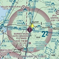
|
| Airport distance calculator |
|---|
|
|
| Sunrise and sunset |
|---|
|
Times for 28-Jul-2026
| | Local
(UTC-5) | | Zulu
(UTC) |
|---|
| Morning civil twilight | | 06:23 | | 11:23 |
| Sunrise | | 06:49 | | 11:49 |
| Sunset | | 20:30 | | 01:30 |
| Evening civil twilight | | 20:56 | | 01:56 |
|
| Current date and time |
|---|
| Zulu (UTC) | 28-Jul-2026 08:03:59 |
|---|
| Local (UTC-5) | 28-Jul-2026 03:03:59 |
|---|
|
| METAR |
|---|
| KBMQ | 280753Z AUTO 16003KT 10SM CLR 25/20 A2994 RMK AO2 SLP116 T02500200
|
KDZB
14nm SW | 280755Z AUTO 00000KT 7SM CLR 25/20 A2991 RMK AO2 T02480200
|
|
| TAF |
|---|
KGRK
29nm NE | 271600Z 2716/2822 16010G15KT 9999 SKC QNH2984INS BECMG 2800/2801 16009KT 9999 SKC QNH2984INS TX37/2721Z TN24/2812Z
|
|
| NOTAMs |
|---|
NOTAMs are issued by the DoD/FAA and will open in a separate window not controlled by AirNav.
|
|


