FAA INFORMATION EFFECTIVE 27 NOVEMBER 2025
Location
| FAA Identifier: | ART |
| Lat/Long: | 43-59-30.6000N 076-01-09.9000W
43-59.510000N 076-01.165000W
43.9918333,-76.0194167
(estimated) |
| Elevation: | 330.8 ft. / 100.8 m (surveyed) |
| Variation: | 12W (1980) |
| From city: | 5 miles W of WATERTOWN, NY |
| Time zone: | UTC -5 (UTC -4 during Daylight Saving Time) |
| Zip code: | 13634 |
Airport Operations
| Airport use: | Open to the public |
| Activation date: | 03/1940 |
| Control tower: | no |
| ARTCC: | BOSTON CENTER |
| FSS: | BURLINGTON FLIGHT SERVICE STATION |
| NOTAMs facility: | ART (NOTAM-D service available) |
| Attendance: | OCT-APR 0600-1800, MAY-SEP 0500-1900 |
| Wind indicator: | lighted |
| Segmented circle: | no |
| Lights: | ACTVT MALSR RWY 07 & 28; REIL RWY 25; HIRL RWY 07/25; MIRL RWY 10/28; TWY LGTS - CTAF. PAPI RWYS 7, 10, 25 & 28 OPR CONSLY. |
| Beacon: | white-green (lighted land airport)
Operates sunset to sunrise. |
| Landing fee: | no, LNDG FEE OVR 6000 LB. |
| Fire and rescue: | ARFF index A |
| Airline operations: | PPR 2 HRS FOR UNSKD OPS WITH MORE THAN 30 PAX SEATS CALL 315-816-2331 OR 315-486-3302. INDEX B COVERAGE IS AVBL O/R. |
| International operations: | international airport of entry
2 HR PPR - US CUSTOMS 315-482-2261. |
Airport Communications
| CTAF/UNICOM: | 123.0 |
| WX ASOS: | 132.325 (315-639-4002) |
| WHEELER-SACK APPROACH: | 124.875 |
| WHEELER-SACK DEPARTURE: | 124.875 |
| CLEARANCE DELIVERY: | 120.8 |
Nearby radio navigation aids
| VOR radial/distance | | VOR name | | Freq | | Var |
|---|
| ARTr051/3.1 | | WATERTOWN VORTAC | | 109.80 | | 12W |
Airport Services
| Fuel available: | 100LL JET-A
100LL:FUEL AFT HRS: 315-816-2334 OR 315-466-6741. |
| Parking: | hangars and tiedowns |
| Airframe service: | MAJOR |
| Powerplant service: | MAJOR |
Runway Information
Runway 10/28
| Dimensions: | 7001 x 150 ft. / 2134 x 46 m |
| Surface: | asphalt/grooved, in good condition |
| Weight bearing capacity: | | Single wheel: | 109.0 | | Double wheel: | 154.0 | | Double tandem: | 254.0 |
|
| Runway edge lights: | medium intensity |
| RUNWAY 10 | | RUNWAY 28 |
| Latitude: | 43-59.535905N | | 43-59.476385N |
| Longitude: | 076-01.839063W | | 076-00.245048W |
| Elevation: | 309.1 ft. | | 330.8 ft. |
| Traffic pattern: | left | | left |
| Runway heading: | 105 magnetic, 093 true | | 285 magnetic, 273 true |
| Declared distances: | TORA:7001 TODA:7001 ASDA:7001 LDA:7001 | | TORA:7001 TODA:7001 ASDA:7001 LDA:7001 |
| Markings: | nonprecision, in fair condition | | precision, in fair condition |
| Visual slope indicator: | 4-light PAPI on left (3.00 degrees glide path) | | 4-light PAPI on left (3.00 degrees glide path) |
| Approach lights: | | | MALSR: 1,400 foot medium intensity approach lighting system with runway alignment indicator lights |
| Runway end identifier lights: | | | no |
| Touchdown point: | yes, no lights | | yes, no lights |
| Obstructions: | 85 ft. trees, 2700 ft. from runway, 620 ft. right of centerline, 29:1 slope to clear | | 85 ft. trees, 2720 ft. from runway, 90 ft. right of centerline, 30:1 slope to clear |
Runway 7/25
| Dimensions: | 4999 x 150 ft. / 1524 x 46 m |
| Surface: | asphalt/grooved, in good condition |
| Weight bearing capacity: | | Single wheel: | 105.0 | | Double wheel: | 147.0 | | Double tandem: | 244.0 |
|
| Runway edge lights: | high intensity |
| Operational restrictions: | RWY 25 CALM WIND RWY. |
| RUNWAY 7 | | RUNWAY 25 |
| Latitude: | 43-59.270460N | | 43-59.760353N |
| Longitude: | 076-01.796567W | | 076-00.880967W |
| Elevation: | 310.3 ft. | | 323.8 ft. |
| Traffic pattern: | left | | left |
| Runway heading: | 065 magnetic, 053 true | | 245 magnetic, 233 true |
| Declared distances: | TORA:4999 TODA:4999 ASDA:4784 LDA:4784 | | TORA:4999 TODA:4999 ASDA:4999 LDA:4999 |
| Markings: | precision, in good condition | | nonprecision, in good condition |
| Visual slope indicator: | 4-light PAPI on left (3.00 degrees glide path) | | 4-light PAPI on left (3.00 degrees glide path) |
| Approach lights: | MALSR: 1,400 foot medium intensity approach lighting system with runway alignment indicator lights | | |
| Runway end identifier lights: | | | yes |
| Touchdown point: | yes, no lights | | yes, no lights |
| Instrument approach: | ILS/DME | | |
| Obstructions: | 75 ft. trees, 1520 ft. from runway, 330 ft. right of centerline, 17:1 slope to clear | | 70 ft. trees, 1095 ft. from runway, 520 ft. left of centerline, 13:1 slope to clear |
Airport Ownership and Management from official FAA records
| Ownership: | Publicly-owned |
| Owner: | COUNTY OF JEFFERSON
195 ARSENAL ST
WATERTOWN, NY 13601
Phone 315-785-3075 |
| Manager: | GRANT W. SUSSEY
22529 AIRPORT DR
DEXTER, NY 13634-3062
Phone 315-786-6002 |
Additional Remarks
| A39-07/25 | PCR VALUE: 601/F/D/X/T |
| A39-10/28 | PCR VALUE: 270/F/D/X/T |
| - | DEER & BIRDS ON & INVOF ARPT. |
| - | CTN: NGT VISION DEVICE OPS CONDUCTED IN TFC PAT AREA. |
| - | RC MODEL ACT 4 NM N & 9 NM SSW BLW 400 FT. |
| - | TWY LGTS NOT VSB USING NGT VISION GOGGLES. |
| - | APN PRKG WT BRG CPTY: 68/F/C/X/T; S-120, D-239, DT-385. |
| - | WX CAMERA AVBL AT WATERTOWNAIRPORT.COM. |
| - | FOR CD IF UNA TO CTC WHEELER SACK ATCT ON FREQ, CTC WHEELER SACK ATCT AT 315-772-7105. |
| - | CTN: RAPID HOT REFUELING ON TRML & GA RAMP. |
| - | GND VEHICLES MNT CTAF. |
| - | US CUSTOMS PRKG AT GA RAMP UNLESS ADZD BY CUSTOMS OR FBO. |
| - | TKS, TYPE I & IV FLUIDS AVBL - CTC FBO. |
| - | 24HR PPR FOR TRNSPN OF XPLOS - CTC AMGR. |
| - | MEDEVAC ON ARPT. GIVEAWAY TO ACFT OR HEL USING MEDEVAC CS. |
| - | WHEELED HEL REQSTD TO GND TAXI WHEN XNG GA RAMP. |
| - | MIL HEL T ON & INVOF ARPT. |
| - | PPR FOR USE OF UNIMPROVED SFCS - AMGR. |
| - | TKS DE/ANTI ICING AVBL - FBO 315-786-6001. |
| - | RWY/TWY COND UNMNTD AFT HRS. |
| - | PAEW ALL SFCS APR-OCT. SN REMOVAL EQUIP OCT-APR. |
Instrument Procedures
NOTE: All procedures below are presented as PDF files. If you need a reader for these files, you should download the free Adobe Reader.NOT FOR NAVIGATION. Please procure official charts for flight.
FAA instrument procedures published for use from 27 November 2025 at 0901Z to 25 December 2025 at 0900Z.
IAPs - Instrument Approach Procedures |
|---|
| ILS OR LOC RWY 07 | |
download (241KB) |
| RNAV (GPS) RWY 07 | |
download (214KB) |
| RNAV (GPS) RWY 10 | |
download (211KB) |
| RNAV (GPS) RWY 28 | |
download (222KB) |
| VOR RWY 07 | |
download (225KB) |
| NOTE: Special Alternate Minimums apply | |
download (165KB) |
| NOTE: Special Take-Off Minimums/Departure Procedures apply | |
download (275KB) |
Other nearby airports with instrument procedures:
KGTB - Wheeler-Sack Army Airfield (13 nm E)
KFZY - Oswego County Airport (42 nm SW)
KOGS - Ogdensburg International Airport (48 nm NE)
KRME - Griffiss International Airport (53 nm SE)
KSYR - Syracuse Hancock International Airport (53 nm S)
|
|

Road maps at:
MapQuest
Bing
Google
| Aerial photo |
|---|
WARNING: Photo may not be current or correct
 Photo by Dan Cregan
Photo taken 10-Nov-2015
looking west.
Photo by Dan Cregan
Photo taken 10-Nov-2015
looking west.
Do you have a better or more recent aerial photo of Watertown International Airport that you would like to share? If so, please send us your photo.
|
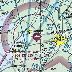
| Sectional chart |
|---|
|
CAUTION: Diagram may not be current
 Download PDF
of official airport diagram from the FAA
| Airport distance calculator |
|---|
|
|
| Sunrise and sunset |
|---|
|
Times for 18-Dec-2025
| | Local
(UTC-5) | | Zulu
(UTC) |
|---|
| Morning civil twilight | | 07:02 | | 12:02 |
| Sunrise | | 07:35 | | 12:35 |
| Sunset | | 16:26 | | 21:26 |
| Evening civil twilight | | 17:00 | | 22:00 |
|
| Current date and time |
|---|
| Zulu (UTC) | 18-Dec-2025 23:52:39 |
|---|
| Local (UTC-5) | 18-Dec-2025 18:52:39 |
|---|
|
| METAR |
|---|
| KART | 182256Z AUTO 18011G19KT 150V210 10SM SCT090 BKN110 09/M03 A2987 RMK AO2 RAB28E43 SLP117 P0000 T00891033
|
KGTB
13nm E | 182255Z AUTO 15009KT 10SM BKN090 BKN110 06/M03 A2986 RMK AO2 RAB25E38 SLP117 P0000 T00601026 $
|
|
| TAF |
|---|
| KART | 181720Z 1818/1918 16011G24KT P6SM SCT250 FM182200 17017G32KT P6SM BKN150 FM190400 17025G43KT 6SM -SHRA OVC035 WS020/19055KT FM191000 18020G38KT 6SM -SHRA OVC020 WS020/19050KT FM191200 24014G28KT 2SM SHRA OVC020
|
KGTB
13nm E | 181700Z 1817/1923 15015G30KT SCT100 510003 QNH2972INS BECMG 1904/1905 16025G45KT 6000 -RA BR OVC050 620703 550003 QNH2925INS BECMG 1911/1912 16020G40KT 6000 -RA BR OVC012 WS020/19060KT 510003 QNH2920INS TEMPO 1912/1914 VRB30G50KT 1600 TSRA BR OVC007 BECMG 1914/1915 20020G35KT 6000 -RA BR OVC007 WS020/17055KT 510003 QNH2916INS BECMG 1918/1919 25015G25KT 3200 -RASN BR OVC015 620156 QNH2925INS BECMG 1921/1922 24020G30KT 3200 -SN BLSN OVC015 620159 510003 QNH2933INS TX07/1912Z TN04/1817Z
|
|
| NOTAMs |
|---|
NOTAMs are issued by the DoD/FAA and will open in a separate window not controlled by AirNav.
|
|


