FAA INFORMATION EFFECTIVE 22 JANUARY 2026
Location
| FAA Identifier: | BBP |
| Lat/Long: | 34-37-18.1510N 079-44-03.6940W
34-37.302517N 079-44.061567W
34.6217086,-79.7343594
(estimated) |
| Elevation: | 146.8 ft. / 44.7 m (surveyed) |
| Variation: | 08W (2005) |
| From city: | 3 miles W of BENNETTSVILLE, SC |
| Time zone: | UTC -5 (UTC -4 during Daylight Saving Time) |
| Zip code: | 29512 |
Airport Operations
| Airport use: | Open to the public |
| Control tower: | no |
| ARTCC: | JACKSONVILLE CENTER |
| FSS: | ANDERSON FLIGHT SERVICE STATION |
| NOTAMs facility: | AND (NOTAM-D service available) |
| Attendance: | MON-SAT 0800-1700, ALL SUN 1300-1700
FOR SVC SUN CALL FBO 843-454-2303. |
| Wind indicator: | lighted |
| Segmented circle: | yes |
| Lights: | SS-SR |
| Beacon: | white-green (lighted land airport)
Operates sunset to sunrise. |
Airport Communications
| CTAF/UNICOM: | 122.8 |
| WX AWOS-3PT: | 123.825 (843-479-5817) |
| FLORENCE APPROACH: | 118.6 [1200-0400Z++ MON-SUN; 1500-2300Z++ HOLS.] |
| FLORENCE DEPARTURE: | 118.6 [1200-0400Z++ MON-SUN; 1500-2300Z++ HOLS.] |
| WX AWOS-3 at CQW (12 nm NW): | 124.825 (843-537-3301) |
| WX AWOS-3PT at UDG (13 nm SW): | 119.925 (843-393-8220) |
| WX AWOS-3 at RCZ (16 nm N): | 118.775 (910-997-4093) |
- APCH/DEP SVC PRVDD BY JACKSONVILLE ATRCC ON FREQS 133.45/306.3 (FLORENCE RCAG) WHEN FLORENCE APCH CTL CLSD.
Nearby radio navigation aids
| VOR radial/distance | | VOR name | | Freq | | Var |
|---|
| FLOr354/23.6 | | FLORENCE VORTAC | | 115.20 | | 03W |
| CTFr097/26.7 | | CHESTERFIELD VOR/DME | | 114.55 | | 03W |
| SDZr194/36.3 | | SANDHILLS VORTAC | | 111.80 | | 03W |
| NDB name | | Hdg/Dist | | Freq | | Var | | ID |
|---|
| HARTSVILLE | | 063/23.0 | | 341 | | 07W | | HVS | .... ...- ... |
Airport Services
| Fuel available: | 100LL JET-A
100LL:FOR FUEL AFTER HRS CALL 843-862-4359. |
| Parking: | hangars and tiedowns |
| Airframe service: | NONE |
| Powerplant service: | NONE |
| Bottled oxygen: | NONE |
| Bulk oxygen: | NONE |
Runway Information
Runway 7/25
| Dimensions: | 5003 x 74 ft. / 1525 x 23 m |
| Surface: | asphalt, in good condition |
| Weight bearing capacity: | | Single wheel: | 28.0 | | Double wheel: | 43.0 | | Double tandem: | 70.0 |
|
| Runway edge lights: | medium intensity |
| RUNWAY 7 | | RUNWAY 25 |
| Latitude: | 34-37.080793N | | 34-37.523927N |
| Longitude: | 079-44.482218W | | 079-43.640845W |
| Elevation: | 138.0 ft. | | 146.8 ft. |
| Traffic pattern: | left | | left |
| Runway heading: | 066 magnetic, 058 true | | 246 magnetic, 238 true |
| Markings: | nonprecision, in good condition | | nonprecision, in good condition |
| Visual slope indicator: | 2-light PAPI on left (3.00 degrees glide path) | | 2-light PAPI on left (3.00 degrees glide path) |
| Runway end identifier lights: | yes | | yes |
| Touchdown point: | yes, no lights | | yes, no lights |
| Obstructions: | 82 ft. tree, 2299 ft. from runway, 359 ft. left of centerline, 25:1 slope to clear | | 88 ft. tree, 2574 ft. from runway, 384 ft. right of centerline, 26:1 slope to clear |
Airport Ownership and Management from official FAA records
| Ownership: | Publicly-owned |
| Owner: | MARLBORO COUNTY
PO BOX 419
BENNETTSVILLE, SC 29512
Phone 843-479-5647 |
| Manager: | MR. BARRY AVENT
P.O. BOX 535, 1231 AIRPORT ROAD
BENNETTSVILLE, SC 29512
Phone (843) 479-4797
COUNTY ADMINISTRATOR. |
Additional Remarks
| - | FOR FBO MGR BARRY AVENT CALL (843)479-4797. |
| - | FOR CD CTC FLORENCE APCH AT 843-665-0632, WHEN APCH CLSD CTC JACKSONVILLE ARTCC AT 904-845-1592. |
Instrument Procedures
NOTE: All procedures below are presented as PDF files. If you need a reader for these files, you should download the free Adobe Reader.NOT FOR NAVIGATION. Please procure official charts for flight.
FAA instrument procedures published for use from 22 January 2026 at 0901Z to 19 February 2026 at 0900z.
IAPs - Instrument Approach Procedures |
|---|
| RNAV (GPS) RWY 07 | |
download (270KB) |
| RNAV (GPS) RWY 25 | |
download (268KB) |
| NOTE: Special Alternate Minimums apply | |
download (169KB) |
| NOTE: Special Take-Off Minimums/Departure Procedures apply | |
download (385KB) |
Other nearby airports with instrument procedures:
KCQW - Cheraw Municipal Airport/Lynch Bellinger Field (12 nm NW)
KUDG - Darlington County Airport (13 nm SW)
KRCZ - Richmond County Airport (16 nm N)
KDLC - Dillon County Airport (21 nm SE)
KMEB - Laurinburg/Maxton Airport (21 nm NE)
|
|

Road maps at:
MapQuest
Bing
Google
| Aerial photo |
|---|
WARNING: Photo may not be current or correct

Do you have a better or more recent aerial photo of Marlboro County Jetport/H E Avent Field Airport that you would like to share? If so, please send us your photo.
|
| Sectional chart |
|---|
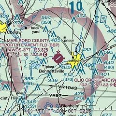
|
| Airport distance calculator |
|---|
|
|
| Sunrise and sunset |
|---|
|
Times for 05-Feb-2026
| | Local
(UTC-5) | | Zulu
(UTC) |
|---|
| Morning civil twilight | | 06:49 | | 11:49 |
| Sunrise | | 07:15 | | 12:15 |
| Sunset | | 17:51 | | 22:51 |
| Evening civil twilight | | 18:17 | | 23:17 |
|
| Current date and time |
|---|
| Zulu (UTC) | 05-Feb-2026 20:47:59 |
|---|
| Local (UTC-5) | 05-Feb-2026 15:47:59 |
|---|
|
| METAR |
|---|
| KBBP | 052035Z AUTO 36007KT 10SM OVC039 03/M02 A2995 RMK AO2
|
KCQW
12nm NW | 052035Z AUTO VRB04KT 10SM OVC038 04/M03 A2994 RMK AO2
|
KUDG
13nm SW | 051956Z AUTO 03009KT 10SM OVC035 03/M02 A2996 RMK AO2 SLP148 T00331022 $
|
KRCZ
16nm N | 052023Z AUTO 02004KT 10SM BKN038 03/M04 A2994 RMK AO2
|
|
| TAF |
|---|
KFLO
26nm S | 051757Z 0518/0618 01010KT 6SM BR BKN025 FM052200 01006KT P6SM SCT020 FM060900 00000KT 5SM BR BKN045 FM061400 VRB04KT P6SM FEW070
|
|
| NOTAMs |
|---|
NOTAMs are issued by the DoD/FAA and will open in a separate window not controlled by AirNav.
|
|

