FAA INFORMATION EFFECTIVE 09 JULY 2026
Location
| FAA Identifier: | BCT |
| Lat/Long: | 26-22-42.5480N 080-06-27.7070W
26-22.709133N 080-06.461783W
26.3784856,-80.1076964
(estimated) |
| Elevation: | 12.9 ft. / 3.9 m (surveyed) |
| Variation: | 05W (2000) |
| From city: | 2 miles NW of BOCA RATON, FL |
| Time zone: | UTC -4 (UTC -5 during Standard Time) |
| Zip code: | 33431 |
Airport Operations
| Airport use: | Open to the public |
| Activation date: | 04/1940 |
| Control tower: | yes |
| ARTCC: | MIAMI CENTER |
| FSS: | MIAMI FLIGHT SERVICE STATION |
| NOTAMs facility: | MIA (NOTAM-D service available) |
| Attendance: | CONTINUOUS |
| Wind indicator: | lighted |
| Segmented circle: | no |
| Lights: | WHEN ATCT CLSD ACTV REIL RWY 05 & 23, PAPI RWY 5 & 23; MIRL RWY 05/23 - CTAF. |
| Beacon: | white-green (lighted land airport)
Operates sunset to sunrise. |
| International operations: | US CUSTOMS USER FEE ARPT. |
Airport Communications
| CTAF: | 118.425 |
| WX AWOS-3: | PHONE 561-391-2696 |
| BOCA RATON GROUND: | 121.8 [0700-2300] |
| BOCA RATON TOWER: | 118.425 [0700-2300] |
| PALM BEACH APPROACH: | 127.35 |
| PALM BEACH DEPARTURE: | 127.35 |
| CLEARANCE DELIVERY: | 121.8 |
| CLMNT STAR: | 124.6 |
| CPTAN STAR: | 124.6 |
| D-ATIS: | 121.125 |
| JESTR STAR: | 124.6 |
| MAHHI STAR: | 127.35 |
| MELBOURNE STAR: | 124.6 |
| MYZNR DP: | 127.35 |
| STOOP STAR: | 124.6 |
| TTYLR STAR: | 125.2 |
| TURPS DP: | 127.35 |
| VUUDU STAR: | 127.35 |
| WX ASOS at PMP (8 nm S): | 120.55 (954-783-3720) |
| WX ASOS at FXE (11 nm S): | 119.85 (954-772-2537) |
| WX AWOS-3PT at LNA (13 nm N): | 119.925 (561-964-0308) |
| WX ASOS at DJT (18 nm N): | 123.75 (561-444-7590) |
| WX ASOS at FLL (19 nm S): | 135.0 (954-359-7857) |
Nearby radio navigation aids
| VOR radial/distance | | VOR name | | Freq | | Var |
|---|
| PBIr187/18.1 | | PALM BEACH VORTAC | | 115.70 | | 03W |
| FLLr016/18.5 | | FORT LAUDERDALE VOR/DME | | 114.40 | | 06W |
| DHPr025/37.1 | | DOLPHIN VORTAC | | 113.90 | | 04W |
| VKZr008/37.7 | | VIRGINIA KEY VOR/DME | | 117.10 | | 04W |
| NDB name | | Hdg/Dist | | Freq | | Var | | ID |
|---|
| UNITED | | 164/34.1 | | 405 | | 05W | | UTX | ..- - -..- |
Airport Services
| Fuel available: | 100LL JET-A |
| Parking: | hangars and tiedowns |
| Airframe service: | MAJOR |
| Powerplant service: | MAJOR |
| Bottled oxygen: | NONE |
| Bulk oxygen: | HIGH/LOW |
Runway Information
Runway 5/23
| Dimensions: | 6276 x 150 ft. / 1913 x 46 m |
| Surface: | asphalt/grooved, in good condition |
| Weight bearing capacity: | | PCN 32 /F/A/X/T | | Single wheel: | 66.0 | | Double wheel: | 95.0 |
|
| Runway edge lights: | medium intensity |
| RUNWAY 5 | | RUNWAY 23 |
| Latitude: | 26-22.338683N | | 26-23.079555N |
| Longitude: | 080-06.863743W | | 080-06.059847W |
| Elevation: | 11.4 ft. | | 12.7 ft. |
| Traffic pattern: | left | | right |
| Runway heading: | 049 magnetic, 044 true | | 229 magnetic, 224 true |
| Displaced threshold: | 696 ft. | | 378 ft. |
| Declared distances: | TORA:6276 TODA:6276 ASDA:6276 LDA:5580 | | TORA:6276 TODA:6276 ASDA:6276 LDA:5898 |
| Markings: | nonprecision, in fair condition | | nonprecision, in fair condition |
| Visual slope indicator: | 4-light PAPI on right (3.25 degrees glide path) | | 4-light PAPI on left (3.25 degrees glide path) |
| Runway end identifier lights: | yes | | yes |
| Touchdown point: | yes, no lights | | yes, no lights |
| Obstructions: | 28 ft. trees, 445 ft. from runway, 55 ft. right of centerline, 8:1 slope to clear
APCH SLOPE 36:1 TO DTRH. | | 15 ft. road, lighted, 270 ft. from runway, 250 ft. right of centerline, 4:1 slope to clear
APCH SLOPE 41:1 TO DSPLCD THLD. |
Airport Ownership and Management from official FAA records
| Ownership: | Publicly-owned |
| Owner: | BOCA RATON AIRPORT AUTHORITY
903 NW 35TH STREET
BOCA RATON, FL 33431
Phone 561-391-2202 |
| Manager: | CLARA BENNETT
903 NW 35TH STREET
BOCA RATON, FL 33431
Phone 561-391-2202
EXT 211 |
Additional Remarks
| E60-05 | ENGINEERED MATERIALS ARRESTING SYS (EMAS) 252 FT IN LEN BY 170 FT IN WID LCTD AT THE DER 05. |
| E60-23 | ENGINEERED MATERIALS ARRESTING SYS (EMAS) 300 FT IN LEN BY 170 FT IN WID LCTD AT THE DER 23. |
| - | NOISE ABATEMENT INFO - AMGR. VOLUNTARY NOISE ABATEMENT PROC IN EFCT ALL TIMES & ACFT. VOLUNTARY CURFEW 2200-0700. USE NBAA STD NOISE ABATEMENT APCH & DEP PROC. |
| - | FOR CD, IF UNA VIA GCO CTC PALM BEACH APCH AT 561-684-9047 OR 561-275-1430. |
| - | WHEN ATCT CLSD, GCO AVBL ON FREQ 127.35 PALM BEACH CD. |
| - | ACFT PRKG LTD DURG VIP TFR PDS. |
| - | 24 HR PPR FOR ACFT EQUIPPED WITH WEATHER MODIFICATION OR GEOENGINEERING EQPT 561-391-2202. |
| - | BIRDS ON AND INVOF ARPT. |
| - | USE RECOMMENDED DEP: RWY 05 L TURN HDG 360 STAY W OF INTERSTATE TO 1500 FT; RWY 23 R TURN HDG 255 AS SOON AS PRACTICABLE AFT PASSING RWY END TO 1500 FT; AVOID RESIDENTIAL AREAS; OVERFLY MALL AREA. |
| - | TGLS VOLUNTARILY RSTRD TO 0900-1700 MON-FRI; VOLUNTARY RESTRN ON STOP & GO LNDGS OR INT DEPS. VOLUNTARY RESTRN ON REPETITIVE PAT OPS. |
| - | MAINT RUNUP NA 0100-1300. |
| - | ACFT PRKG LTD DURG VIP TFR PDS. |
| - | US CUSTS USER FEE ARPT. US CUSTS AVBL THUR-MON 1030-1830 LCL - 561-292-9231. CLSD TO ARR OUTSIDE NML HR EXC O/R AND APVL BY US CUSTS; MNM ADDNL FEE. CTC US CUSTS 561-665-5842 FOR AFT HR APVL. |
Instrument Procedures
NOTE: All procedures below are presented as PDF files. If you need a reader for these files, you should download the free Adobe Reader.NOT FOR NAVIGATION. Please procure official charts for flight.
FAA instrument procedures published for use from 09 July 2026 at 0901Z to 06 August 2026 at 0900Z.
STARs - Standard Terminal Arrivals |
|---|
| CLMNT THREE (RNAV) **NEW** | |
2 pages:
[1] [2] (289KB) |
| CLMNT THREE (RNAV), CONT.2 **NEW** | |
download (201KB) |
| CPTAN FOUR (RNAV) **NEW** | |
2 pages:
[1] [2] (383KB) |
| CPTAN FOUR (RNAV), CONT.2 **NEW** | |
download (261KB) |
| JESTR TWO (RNAV) **NEW** | |
2 pages:
[1] [2] (278KB) |
| MAHHI FOUR (RNAV) **NEW** | |
download (188KB) |
| MELBOURNE THREE **NEW** | |
download (121KB) |
| STOOP FOUR **NEW** | |
download (129KB) |
| TTYLR FIVE **NEW** | |
download (169KB) |
| VUUDU TWO (RNAV) **NEW** | |
2 pages:
[1] [2] (475KB) |
| VUUDU TWO (RNAV), CONT.2 **NEW** | |
download (193KB) |
IAPs - Instrument Approach Procedures |
|---|
| RNAV (RNP) Z RWY 23 | |
download (213KB) |
| RNAV (GPS) RWY 05 **CHANGED** | |
download (263KB) |
| RNAV (GPS) Y RWY 23 | |
download (256KB) |
| NOTE: Special Alternate Minimums apply | |
download (146KB) |
Departure Procedures |
|---|
| MYZNR THREE (RNAV) | |
download (260KB) |
| TURPS TWO (RNAV) | |
download (200KB) |
| NOTE: Special Take-Off Minimums/Departure Procedures apply | |
download (162KB) |
Other nearby airports with instrument procedures:
KPMP - Pompano Beach Airpark (8 nm S)
KFXE - Fort Lauderdale Executive Airport (11 nm S)
KLNA - Palm Beach County Park Airport (13 nm N)
KDJT - President Donald J Trump International Airport (18 nm N)
KFLL - Fort Lauderdale/Hollywood International Airport (19 nm S)
|
|

Road maps at:
MapQuest
Bing
Google
| Aerial photo |
|---|
WARNING: Photo may not be current or correct
 Photo courtesy of Russell Aerial Photography
Taken in April 2012
looking southeast.
Photo courtesy of Russell Aerial Photography
Taken in April 2012
looking southeast.
Do you have a better or more recent aerial photo of Boca Raton Airport that you would like to share? If so, please send us your photo.
|
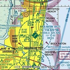
| Sectional chart |
|---|
|
CAUTION: Diagram may not be current
 Download PDF
of official airport diagram from the FAA
| Airport distance calculator |
|---|
|
|
| Sunrise and sunset |
|---|
|
Times for 31-Jul-2026
| | Local
(UTC-4) | | Zulu
(UTC) |
|---|
| Morning civil twilight | | 06:21 | | 10:21 |
| Sunrise | | 06:46 | | 10:46 |
| Sunset | | 20:07 | | 00:07 |
| Evening civil twilight | | 20:32 | | 00:32 |
|
| Current date and time |
|---|
| Zulu (UTC) | 31-Jul-2026 09:43:41 |
|---|
| Local (UTC-4) | 31-Jul-2026 05:43:41 |
|---|
|
| METAR |
|---|
| KBCT | 310915Z AUTO 23003KT 10SM CLR 26/25 A3003 RMK AO2 LTG DSNT NE
|
KPMP
8nm S | 310853Z 24005KT 10SM CLR 27/25 A3002 RMK AO2 SLP165 T02720250 56010
|
KFXE
11nm S | 310853Z AUTO 24004KT 10SM CLR 26/26 A3001 RMK AO2 SLP164 T02610261 56010
|
KLNA
13nm N | 310915Z AUTO 25003KT 10SM CLR 27/23 A3002 RMK AO2 T02700225
|
KDJT
18nm N | 310853Z 23004KT 10SM FEW180 SCT250 27/24 A3001 RMK AO2 SLP162 T02720244 56012 $
|
KFLL
19nm S | 310853Z 23004KT 10SM FEW040 SCT250 27/25 A3001 RMK AO2 SLP161 6//// T02720250 56011 PNO $
|
|
| TAF |
|---|
KFXE
11nm S | 310536Z 3106/0106 VRB05KT P6SM FEW030 SCT250 FM311500 24008KT P6SM VCSH SCT030 SCT050 FM311900 19010KT P6SM VCTS SCT030CB BKN050 FM010000 VRB04KT P6SM SCT030 SCT050 BKN250
|
KDJT
18nm N | 310536Z 3106/0106 VRB05KT P6SM FEW030 SCT250 FM311500 25008KT P6SM VCSH SCT030 SCT050 FM311900 20010KT P6SM VCTS SCT030CB BKN050 PROB30 3119/3124 VRB15G25KT 3SM TSRA BKN025CB FM010000 VRB05KT P6SM SCT030 BKN050 BKN250
|
KFLL
19nm S | 310536Z 3106/0112 VRB05KT P6SM FEW030 SCT250 FM311500 24007KT P6SM VCSH SCT030 SCT050 FM311900 19010KT P6SM VCTS SCT030CB BKN050 FM010000 VRB05KT P6SM SCT030 SCT050 BKN250
|
|
| NOTAMs |
|---|
NOTAMs are issued by the DoD/FAA and will open in a separate window not controlled by AirNav.
|
|


