FAA INFORMATION EFFECTIVE 09 JULY 2026
Location
| FAA Identifier: | FXE |
| Lat/Long: | 26-11-50.2057N 080-10-14.5426W
26-11.836762N 080-10.242377W
26.1972794,-80.1707063
(estimated) |
| Elevation: | 13.4 ft. / 4.1 m (surveyed) |
| Variation: | 07W (2015) |
| From city: | 5 miles N of FORT LAUDERDALE, FL |
| Time zone: | UTC -4 (UTC -5 during Standard Time) |
| Zip code: | 33309 |
Airport Operations
| Airport use: | Open to the public |
| Activation date: | 07/1944 |
| Control tower: | yes |
| ARTCC: | MIAMI CENTER |
| FSS: | MIAMI FLIGHT SERVICE STATION |
| NOTAMs facility: | FXE (NOTAM-D service available) |
| Attendance: | CONTINUOUS |
| Wind indicator: | lighted |
| Segmented circle: | yes |
| Lights: | SS-SR |
| Beacon: | white-green (lighted land airport)
Operates sunset to sunrise. |
| International operations: | customs landing rights airport
US CUSTOMS AVBL 0800-2359. |
Airport Communications
| UNICOM: | 122.95 |
| ATIS: | 119.85 |
| WX ASOS: | 119.85 (954-772-2537) |
| EXECUTIVE GROUND: | 121.75 |
| EXECUTIVE TOWER: | 120.9 239.3 |
| MIAMI APPROACH: | 119.7 |
| MIAMI DEPARTURE: | 119.7 |
| CLEARANCE DELIVERY: | 127.95 |
| BHHIA STAR: | 120.5 |
| BNICE DP: | 126.05 |
| CPTAN STAR: | 124.6 |
| DEKAL STAR: | 126.85 |
| DORRL DP: | 126.05 |
| FEALX DP: | 126.05 |
| FORT LAUDERDALE DP: | 126.05 ;AARPS, BNICE, DORRL,FRSBE, H 126.05 ;BEECH-FLL DEPARTING WEST 126.85 ;BEECH-FLL DEPARTING EAST 126.85 ;MAYNR |
| FORTL STAR: | 133.775 |
| FRSBE DP: | 126.05 |
| GABOW DP: | 126.05 |
| HROCK DP: | 126.05 |
| JESTR STAR: | 124.6 |
| KYAKS STAR: | 128.6 |
| LIFRR DP: | 126.05 |
| MAYNR DP: | 126.05 |
| OLAHS STAR: | 126.85 ;6000 FT AND ABV 128.6 ;5000 FT & BLW |
| TEEKY STAR: | 133.775 |
| TOREZ STAR: | 126.85 |
| WX ASOS at PMP (4 nm NE): | 120.55 (954-783-3720) |
| WX ASOS at FLL (8 nm S): | 135.0 (954-359-7857) |
| WX AWOS-3 at BCT (11 nm N): | PHONE 561-391-2696 |
| WX ASOS at HWO (12 nm S): | 135.475 (954-983-5904) |
| WX ASOS at OPF (18 nm S): | 125.9 (305-681-4063) |
- MIAMI APCH/DEP FREQS USABLE 4000' AND BELOW.
- SAID IN USE. OPERATE TRANSPONDERS WITH ALTITUDE REPORTING MODE AND ADS-B (IF EQUIPPED) ENABLED ON ALL AIRPORT SURFACES.
Nearby radio navigation aids
| VOR radial/distance | | VOR name | | Freq | | Var |
|---|
| FLLr004/7.4 | | FORT LAUDERDALE VOR/DME | | 114.40 | | 06W |
| DHPr026/25.7 | | DOLPHIN VORTAC | | 113.90 | | 04W |
| VKZr002/26.7 | | VIRGINIA KEY VOR/DME | | 117.10 | | 04W |
| PBIr192/29.3 | | PALM BEACH VORTAC | | 115.70 | | 03W |
Airport Services
| Fuel available: | 100LL JET-A |
| Parking: | hangars and tiedowns |
| Airframe service: | MAJOR |
| Powerplant service: | MAJOR |
| Bottled oxygen: | HIGH |
| Bulk oxygen: | HIGH |
Runway Information
Runway 9/27
| Dimensions: | 6002 x 100 ft. / 1829 x 30 m |
| Surface: | asphalt/grooved, in excellent condition |
| Weight bearing capacity: | | PCN 18 /F/A/X/T | | Single wheel: | 56.0 | | Double wheel: | 81.0 |
|
| Runway edge lights: | high intensity |
| RUNWAY 9 | | RUNWAY 27 |
| Latitude: | 26-11.854473N | | 26-11.961803N |
| Longitude: | 080-10.851928W | | 080-09.760190W |
| Elevation: | 11.7 ft. | | 11.8 ft. |
| Traffic pattern: | left | | left |
| Runway heading: | 091 magnetic, 084 true | | 271 magnetic, 264 true |
| Markings: | precision, in good condition | | precision, in good condition |
| Visual slope indicator: | 4-light PAPI on left (3.00 degrees glide path) | | 4-light PAPI on left (3.25 degrees glide path) |
| Approach lights: | MALSR: 1,400 foot medium intensity approach lighting system with runway alignment indicator lights | | |
| Runway end identifier lights: | | | yes |
| Touchdown point: | yes, no lights | | yes, no lights |
| Instrument approach: | ILS | | |
| Obstructions: | 74 ft. trees, 3685 ft. from runway, 110 ft. right of centerline, 47:1 slope to clear | | 131 ft. bldg, lighted, 4760 ft. from runway, 75 ft. left of centerline, 35:1 slope to clear |
Runway 13/31
| Dimensions: | 4000 x 100 ft. / 1219 x 30 m |
| Surface: | asphalt/grooved, in fair condition |
| Weight bearing capacity: | | PCN 26 /F/B/X/T | | Single wheel: | 30.0 | | Double wheel: | 60.0 |
|
| Runway edge lights: | medium intensity |
| Operational restrictions: | RY 13/31 CLSD 2200-0700 WHEN RY 09/27 IS OPERATIONAL FULL LENGTH. |
| RUNWAY 13 | | RUNWAY 31 |
| Latitude: | 26-11.936595N | | 26-11.522922N |
| Longitude: | 080-10.432070W | | 080-09.861643W |
| Elevation: | 12.3 ft. | | 10.9 ft. |
| Traffic pattern: | left | | left |
| Runway heading: | 136 magnetic, 129 true | | 316 magnetic, 309 true |
| Markings: | nonprecision, in good condition | | nonprecision, in good condition |
| Visual slope indicator: | 2-light PAPI on left (3.25 degrees glide path) | | 2-light PAPI on left (3.25 degrees glide path) |
| Runway end identifier lights: | yes | | yes |
| Touchdown point: | yes, no lights | | yes, no lights |
| Obstructions: | 36 ft. tree, 1078 ft. from runway, 100 ft. left of centerline, 25:1 slope to clear | | 13 ft. road, 645 ft. from runway, 125 ft. right of centerline, 34:1 slope to clear |
Airport Ownership and Management from official FAA records
| Ownership: | Publicly-owned |
| Owner: | CITY OF FORT LAUDERDALE
PO BOX 14250
FORT LAUDERDALE, FL 33301
Phone 954-828-5000
CONTACT PERSON: RUFUS JAMES 954-828-4968 |
| Manager: | RUFUS JAMES
6000 NW 21ST AVE
FT LAUDERDALE, FL 33309
Phone 954-828-4968 |
Additional Remarks
| - | REQUEST PROGRESSIVE TAXI IF UNFAMILIAR. |
| - | MAINTENANCE ENGINE RUN-UPS PROHIBITED 1900-0700. |
| - | RY 27 NIGHTTIME PREFERENTIAL USE RY FOR ALL ACFT DEPARTURES WHEN WINDS PERMIT. |
| - | RY 09 NIGHTTIME PREFERENTIAL USE RY FOR ALL ACFT ARRIVALS WHEN WINDS PERMIT. |
| - | NOISE ABATEMENT PROCEDURES IN EFFECT CALL AMGR 954-828-4955. |
| - | US CUSTOMS RAMP CLOSED TO ARRIVING AIRCRAFT 0000-0800. |
| - | PPR FOR ACFT IN EXCESS OF RY WEIGHT BEARING CAPACITY. CALL AMGR MON-FRI 954-828-4955. |
| - | PORTIONS OF RY 31 RUN-UP AREA(WEST OF TWY 'B')ARE NOT VISIBLE FROM THE ATCT. |
| - | CUSTOMS RAMP LOCATED TWY G7. |
| - | USE CTN FOR DRONES AUTH AOB 400 FT WI CLASS D. |
| - | 24 HR ADVN NOTICE OR IMT REPORTING UPON LDG FOR ACFT EQUIPPED WITH WEATHER MODIFICATION OR GEOENGINEERING EQUIP 954-828-4955 |
| - | FLOCKS OF BIRDS ON & INVOF ARPT. |
| - | ALL ACFT OPERATORS AVOID OVERFLIGHTS OF RESIDENTIAL AREA ONE-HALF MILE SW OF ATCT. |
| - | TAXILANE 'C'(SW OF TWY 'B') IS A NON-CONTROLLED OPERATIONAL AREA. |
Instrument Procedures
NOTE: All procedures below are presented as PDF files. If you need a reader for these files, you should download the free Adobe Reader.NOT FOR NAVIGATION. Please procure official charts for flight.
FAA instrument procedures published for use from 09 July 2026 at 0901Z to 06 August 2026 at 0900Z.
STARs - Standard Terminal Arrivals |
|---|
| BHHIA THREE (RNAV) **NEW** | |
2 pages:
[1] [2] (393KB) |
| BHHIA THREE (RNAV), CONT.2 **NEW** | |
download (148KB) |
| CPTAN FOUR (RNAV) **NEW** | |
2 pages:
[1] [2] (383KB) |
| CPTAN FOUR (RNAV), CONT.2 **NEW** | |
download (261KB) |
| DEKAL NINE **NEW** | |
download (214KB) |
| DVALL FOUR **NEW** | |
download (144KB) |
| FORTL NINE **NEW** | |
download (185KB) |
| JESTR TWO (RNAV) **NEW** | |
2 pages:
[1] [2] (278KB) |
| KYAKS THREE (RNAV) **NEW** | |
2 pages:
[1] [2] (305KB) |
| OLAHS THREE (RNAV) **NEW** | |
2 pages:
[1] [2] (404KB) |
| OLAHS THREE (RNAV), CONT.2 **NEW** | |
download (162KB) |
| TEEKY FOUR (RNAV) **NEW** | |
2 pages:
[1] [2] (586KB) |
| TOREZ ONE (RNAV) **NEW** | |
download (151KB) |
IAPs - Instrument Approach Procedures |
|---|
| ILS OR LOC RWY 09 | |
download (280KB) |
| RNAV (GPS) RWY 09 | |
download (232KB) |
| RNAV (GPS) RWY 27 | |
download (233KB) |
| NOTE: Special Alternate Minimums apply | |
download (149KB) |
Departure Procedures |
|---|
| BNICE TWO (RNAV) | |
download (218KB) |
| DORRL TWO (RNAV) | |
download (226KB) |
| FEALX TWO (RNAV) | |
2 pages:
[1] [2] (302KB) |
| FORT LAUDERDALE TWO | |
2 pages:
[1] [2] (388KB) |
| FORT LAUDERDALE TWO | |
2 pages:
[1] [2] (388KB) |
| FRSBE TWO (RNAV) | |
download (205KB) |
| GABOW TWO (RNAV) | |
download (231KB) |
| HROCK TWO (RNAV) | |
2 pages:
[1] [2] (282KB) |
| LIFRR TWO (RNAV) | |
download (214KB) |
| MAYNR THREE (RNAV) | |
2 pages:
[1] [2] (261KB) |
| NOTE: Special Take-Off Minimums/Departure Procedures apply | |
download (408KB) |
Other nearby airports with instrument procedures:
KPMP - Pompano Beach Airpark (4 nm NE)
KFLL - Fort Lauderdale/Hollywood International Airport (8 nm S)
KBCT - Boca Raton Airport (11 nm N)
KHWO - North Perry Airport (12 nm S)
KOPF - Miami-Opa Locka Executive Airport (18 nm S)
|
|

Road maps at:
MapQuest
Bing
Google
| Aerial photo |
|---|
WARNING: Photo may not be current or correct
 Photo by William Ward
Photo taken 02-Feb-2020
looking east-southeast.
Photo by William Ward
Photo taken 02-Feb-2020
looking east-southeast.
Do you have a better or more recent aerial photo of Fort Lauderdale Executive Airport that you would like to share? If so, please send us your photo.
|
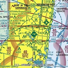
| Sectional chart |
|---|
|
CAUTION: Diagram may not be current
 Download PDF
of official airport diagram from the FAA
| Airport distance calculator |
|---|
|
|
| Sunrise and sunset |
|---|
|
Times for 21-Jul-2026
| | Local
(UTC-4) | | Zulu
(UTC) |
|---|
| Morning civil twilight | | 06:16 | | 10:16 |
| Sunrise | | 06:42 | | 10:42 |
| Sunset | | 20:12 | | 00:12 |
| Evening civil twilight | | 20:38 | | 00:38 |
|
| Current date and time |
|---|
| Zulu (UTC) | 21-Jul-2026 18:08:57 |
|---|
| Local (UTC-4) | 21-Jul-2026 14:08:57 |
|---|
|
| METAR |
|---|
| KFXE | 211753Z 15014G20KT 10SM SCT040 34/25 A3002 RMK AO2 SLP169 T03390250 10339 20294 $
|
KPMP
4nm NE | 211753Z 14011G18KT 10SM CLR 33/24 A3003 RMK AO2 SLP170 T03330239 10339 20300 58002
|
KFLL
8nm S | 211753Z 14015G21KT 10SM FEW035 FEW150 FEW250 33/24 A3003 RMK AO2 SLP166 6//// T03280239 10333 20300 58002 PNO
|
KBCT
12nm N | 211753Z 14013G18KT 10SM FEW055 33/23 A3004
|
KHWO
12nm S | 211753Z 16010KT 10SM FEW050 34/22 A3002 RMK AO2 SLP167 T03390217 10339 20300 58004 $
|
KOPF
18nm S | 211753Z 17013G18KT 10SM FEW044 34/22 A3003 RMK AO2 SLP169 T03390217 10344 20294 58004
|
|
| TAF |
|---|
| KFXE | 211725Z 2118/2218 14012KT P6SM FEW030 FM220200 12006KT P6SM FEW050
|
KFLL
8nm S | 211725Z 2118/2224 14013G23KT P6SM FEW030 FM220200 13010KT P6SM FEW050
|
KOPF
18nm S | 211526Z 2115/2212 15009KT P6SM FEW030 SCT050 FM211800 15011KT P6SM SCT025 BKN050 FM220200 13006KT P6SM FEW050
|
|
| NOTAMs |
|---|
NOTAMs are issued by the DoD/FAA and will open in a separate window not controlled by AirNav.
|
|


