FAA INFORMATION EFFECTIVE 11 JUNE 2026
Location
| FAA Identifier: | BRG |
| Lat/Long: | 34-38-45.1019N 106-50-10.8243W
34-38.751698N 106-50.180405W
34.6458616,-106.8363401
(estimated) |
| Elevation: | 5199.5 ft. / 1585 m (estimated) |
| Variation: | 11E (1985) |
| From city: | 3 miles W of BELEN, NM |
| Time zone: | UTC -6 (UTC -7 during Standard Time) |
| Zip code: | 87002 |
Airport Operations
| Airport use: | Open to the public |
| Activation date: | 05/1979 |
| Control tower: | no |
| ARTCC: | ALBUQUERQUE CENTER |
| FSS: | ALBUQUERQUE FLIGHT SERVICE STATION |
| NOTAMs facility: | BRG (NOTAM-D service available) |
| Attendance: | MON-FRI 0800-1700 |
| Wind indicator: | lighted |
| Segmented circle: | yes |
| Lights: | ACTVT PVASI RWY 21; MIRL RWY 03/21 - CTAF. |
| Beacon: | white-green (lighted land airport)
Operates sunset to sunrise. |
Airport Communications
| CTAF/UNICOM: | 122.8 |
| WX AWOS-3PT: | 118.55 (505-864-4375) |
| ALBUQUERQUE APPROACH: | 123.9 |
| ALBUQUERQUE DEPARTURE: | 123.9 |
Nearby radio navigation aids
| VOR radial/distance | | VOR name | | Freq | | Var |
|---|
| ONMr345/18.4 | | SOCORRO VORTAC | | 116.80 | | 13E |
| ABQr169/23.9 | | ALBUQUERQUE VORTAC | | 113.20 | | 13E |
Airport Services
| Fuel available: | 100LL JET-A1+
100LL:AFT HR FULL SVC JET A - AMGR. 100LL & JET A SELF SVC H24 WITH CREDIT CARD. |
| Parking: | hangars and tiedowns |
| Airframe service: | MAJOR |
| Powerplant service: | MAJOR |
Runway Information
Runway 3/21
| Dimensions: | 6601 x 60 ft. / 2012 x 18 m |
| Surface: | asphalt, in excellent condition |
| Weight bearing capacity: | | PCN 10 /F/D/X/T | | Single wheel: | 12.5 |
|
| Runway edge lights: | medium intensity |
| RUNWAY 3 | | RUNWAY 21 |
| Latitude: | 34-38.326217N | | 34-39.095333N |
| Longitude: | 106-50.487500W | | 106-49.556600W |
| Elevation: | 5193.9 ft. | | 5174.0 ft. |
| Traffic pattern: | left | | right |
| Runway heading: | 034 magnetic, 045 true | | 214 magnetic, 225 true |
| Markings: | nonprecision, in good condition | | nonprecision, in good condition |
| Visual slope indicator: | | | pulsating/steady burning VASI on left (3.00 degrees glide path) |
| Touchdown point: | yes, no lights | | yes, no lights |
Runway 13/31
| Dimensions: | 5280 x 75 ft. / 1609 x 23 m |
| Surface: | asphalt, in good condition |
| Weight bearing capacity: | |
| Operational restrictions: | OVR 160000 LB NA. 4-8 IN DROP ALG N EDGE. |
| RUNWAY 13 | | RUNWAY 31 |
| Latitude: | 34-39.110513N | | 34-38.495243N |
| Longitude: | 106-50.750750W | | 106-50.006082W |
| Elevation: | 5199.5 ft. | | 5176.4 ft. |
| Traffic pattern: | right | | left |
| Runway heading: | 124 magnetic, 135 true | | 304 magnetic, 315 true |
| Markings: | basic, in good condition | | basic, in good condition |
| Touchdown point: | yes, no lights | | yes, no lights |
Airport Ownership and Management from official FAA records
| Ownership: | Publicly-owned |
| Owner: | CITY OF BELEN
100 S. MAIN STREET
BELEN, NM 87002
Phone 505-966-2733 |
| Manager: | JOHN THOMPSON
248 SHILOH WAY
BELEN, NM 87002
Phone (505) 966-2650 |
Additional Remarks
| A58-03 | +2 FT DIRT BERM 90 FT L & R CNTRLN 60-200 FT FM THR. |
| - | MIL TRNG H24; RADIO RQRD. |
| - | FOR CD CTC ALBUQUERQUE ARTCC AT 505-856-4861. |
Instrument Procedures
NOTE: All procedures below are presented as PDF files. If you need a reader for these files, you should download the free Adobe Reader.NOT FOR NAVIGATION. Please procure official charts for flight.
FAA instrument procedures published for use from 11 June 2026 at 0901Z to 09 July 2026 at 0900z.
IAPs - Instrument Approach Procedures |
|---|
| RNAV (GPS) RWY 21 | |
download (238KB) |
| NOTE: Special Take-Off Minimums/Departure Procedures apply | |
download (179KB) |
Other nearby airports with instrument procedures:
KABQ - Albuquerque International Sunport Airport (26 nm NE)
KAEG - Double Eagle II Airport (30 nm N)
KONM - Socorro Municipal Airport (38 nm S)
0E0 - Moriarty Municipal Airport (46 nm NE)
KGNT - Grants-Milan Municipal Airport (61 nm NW)
|
|

Road maps at:
MapQuest
Bing
Google
| Aerial photo |
|---|
WARNING: Photo may not be current or correct
 Photo courtesy of EaglesEyePhoto.com
Photo taken 21-Nov-2016
looking west.
Photo courtesy of EaglesEyePhoto.com
Photo taken 21-Nov-2016
looking west.
Do you have a better or more recent aerial photo of Belen Regional Airport that you would like to share? If so, please send us your photo.
|
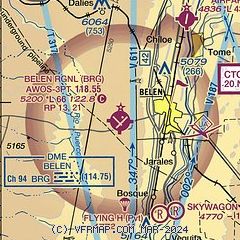
| Sectional chart |
|---|
|
| Airport distance calculator |
|---|
|
|
| Sunrise and sunset |
|---|
|
Times for 30-Jun-2026
| | Local
(UTC-6) | | Zulu
(UTC) |
|---|
| Morning civil twilight | | 05:29 | | 11:29 |
| Sunrise | | 05:59 | | 11:59 |
| Sunset | | 20:23 | | 02:23 |
| Evening civil twilight | | 20:53 | | 02:53 |
|
| Current date and time |
|---|
| Zulu (UTC) | 30-Jun-2026 14:06:55 |
|---|
| Local (UTC-6) | 30-Jun-2026 08:06:55 |
|---|
|
| METAR |
|---|
| KBRG | 301355Z AUTO 00000KT 10SM BKN095 24/00 A3011 RMK AO2 T02410000
|
|
| TAF |
|---|
KABQ
27nm NE | 301120Z 3012/0112 VRB05KT P6SM SCT100 FM301800 20007KT P6SM SCT120 FM302100 20016G28KT P6SM BKN120 PROB30 3022/0102 VRB20G35KT -SHRA BKN110 FM010200 17013KT P6SM BKN120 FM010500 15007KT P6SM SCT120
|
KAEG
29nm N | 301120Z 3012/0112 25007KT P6SM FEW100 FM301900 18017G29KT P6SM SCT120 PROB30 3021/0101 VRB20G35KT 6SM -SHRA BLDU BKN110 FM010100 18015G25KT P6SM BKN110 FM010400 24009KT P6SM SCT120 AMD NOT SKED
|
|
| NOTAMs |
|---|
NOTAMs are issued by the DoD/FAA and will open in a separate window not controlled by AirNav.
|
|


