FAA INFORMATION EFFECTIVE 25 DECEMBER 2025
Location
| FAA Identifier: | BTL |
| Lat/Long: | 42-18-23.3021N 085-15-00.3202W
42-18.388368N 085-15.005337W
42.3064728,-85.2500889
(estimated) |
| Elevation: | 951.8 ft. / 290.1 m (surveyed) |
| Variation: | 04W (1985) |
| From city: | 3 miles W of BATTLE CREEK, MI |
| Time zone: | UTC -5 (UTC -4 during Daylight Saving Time) |
| Zip code: | 49015 |
Airport Operations
| Airport use: | Open to the public |
| Activation date: | 04/1940 |
| Control tower: | yes |
| ARTCC: | CHICAGO CENTER |
| FSS: | LANSING FLIGHT SERVICE STATION |
| NOTAMs facility: | BTL (NOTAM-D service available) |
| Attendance: | CONTINUOUS |
| Wind indicator: | lighted |
| Segmented circle: | yes |
| Lights: | WHEN ATCT CLSD ACTVT MALSR RWY 23R; REIL RWY 05L, 05R, 23L, 13, & 31; PAPI RWY 05L, 23R, 05R, 23L, 13, & 31; HIRL RWY 05L/23R; MIRL RWY 05R/23L & 13/31 - CTAF. |
| Beacon: | white-green (lighted land airport)
Operates sunset to sunrise. |
| Landing fee: | yes |
| International operations: | customs landing rights airport |
Airport Communications
| CTAF: | 126.825 |
| UNICOM: | 122.95 |
| ATIS: | 128.325 |
| WX ASOS: | PHONE 269-964-0283 |
| BATTLE CREEK GROUND: | 121.7 [0700-2300] |
| BATTLE CREEK TOWER: | 126.825 [0700-2300] |
| GREAT LAKES APPROACH: | 119.2 |
| GREAT LAKES DEPARTURE: | 119.2 |
| ANG OPS: | 46.85 |
| EMERG: | 243.0 |
| WX AWOS-3 at RMY (13 nm E): | 120.025 (269-781-9070) |
| WX ASOS at AZO (14 nm W): | PHONE 269-459-3391 |
- APCH/DEP SVC PRVDD BY CHICAGO ARTCC ON 127.55/307.175 (GOSHEN RCAG) WHEN GREAT LAKES APCH CTL CLSD.
Nearby radio navigation aids
| VOR radial/distance | | VOR name | | Freq | | Var |
|---|
| VIOr163/30.8 | | VICTORY VOR/DME | | 115.95 | | 04W |
| PMMr104/39.1 | | PULLMAN VOR/DME | | 112.10 | | 00E |
| NDB name | | Hdg/Dist | | Freq | | Var | | ID |
|---|
| BATOL | | 225/4.4 | | 272 | | 04W | | BT | -... - |
| STURGIS | | 019/30.7 | | 382 | | 04W | | IRS | .. .-. ... |
Airport Services
| Fuel available: | 100LL JET-A+ |
| Parking: | hangars and tiedowns |
| Airframe service: | MAJOR |
| Powerplant service: | MAJOR |
| Bottled oxygen: | HIGH |
| Bulk oxygen: | NONE |
Runway Information
Runway 5L/23R
| Dimensions: | 10004 x 150 ft. / 3049 x 46 m |
| Surface: | asphalt/grooved, in good condition |
| Weight bearing capacity: | | PCN 27 /F/B/X/T | | Single wheel: | 100.0 | | Double wheel: | 200.0 | | Double tandem: | 400.0 | | Dual double tandem: | 900.0 |
|
| Runway edge lights: | high intensity |
| RUNWAY 5L | | RUNWAY 23R |
| Latitude: | 42-17.743883N | | 42-18.956210N |
| Longitude: | 085-15.958715W | | 085-14.456763W |
| Elevation: | 951.8 ft. | | 928.4 ft. |
| Traffic pattern: | left | | left
RIGHT TFC WHEN TWR CLSD. |
| Runway heading: | 047 magnetic, 043 true | | 227 magnetic, 223 true |
| Declared distances: | TORA:10004 TODA:10004 ASDA:10004 LDA:10004 | | TORA:10004 TODA:10004 ASDA:10004 LDA:10004 |
| Markings: | nonprecision, in fair condition | | precision, in fair condition |
| Visual slope indicator: | 4-light PAPI on left (3.00 degrees glide path) | | 4-light PAPI on left (3.00 degrees glide path) |
| RVR equipment: | rollout | | touchdown |
| Approach lights: | | | MALSR: 1,400 foot medium intensity approach lighting system with runway alignment indicator lights |
| Runway end identifier lights: | yes | | |
| Touchdown point: | yes, no lights | | yes, no lights |
| Instrument approach: | | | ILS |
| Obstructions: | 102 ft. tree, 3231 ft. from runway, 500 ft. left of centerline, 29:1 slope to clear | | 44 ft. tree, lighted, 1052 ft. from runway, 591 ft. right of centerline, 19:1 slope to clear |
Runway 13/31
| Dimensions: | 4835 x 100 ft. / 1474 x 30 m |
| Surface: | asphalt/grooved, in good condition |
| Weight bearing capacity: | | PCN 15 /F/C/X/T | | Single wheel: | 40.0 | | Double wheel: | 65.0 | | Double tandem: | 100.0 |
|
| Runway edge lights: | medium intensity |
| RUNWAY 13 | | RUNWAY 31 |
| Latitude: | 42-18.850113N | | 42-18.380958N |
| Longitude: | 085-15.275575W | | 085-14.408603W |
| Elevation: | 919.8 ft. | | 929.4 ft. |
| Traffic pattern: | left | | left |
| Runway heading: | 130 magnetic, 126 true | | 310 magnetic, 306 true |
| Declared distances: | TORA:4835 TODA:4835 ASDA:4835 LDA:4835 | | TORA:4835 TODA:4835 ASDA:4835 LDA:4835 |
| Markings: | nonprecision, in fair condition | | nonprecision, in fair condition |
| Visual slope indicator: | 4-light PAPI on left (3.00 degrees glide path) | | 4-light PAPI on left (3.00 degrees glide path) |
| Runway end identifier lights: | yes | | yes |
| Touchdown point: | yes, no lights | | yes, no lights |
| Obstructions: | 17 ft. pole, 474 ft. from runway, 57 ft. right of centerline, 16:1 slope to clear | | 34 ft. tree, 675 ft. from runway, 250 ft. right of centerline, 13:1 slope to clear |
Runway 5R/23L
| Dimensions: | 4100 x 75 ft. / 1250 x 23 m |
| Surface: | asphalt, in poor condition
EXTSV CRACKING & VEGETATION. |
| Weight bearing capacity: | | PCN 13 /F/C/X/T | | Single wheel: | 12.5 |
|
| Runway edge lights: | medium intensity |
| RUNWAY 5R | | RUNWAY 23L |
| Latitude: | 42-17.965553N | | 42-18.462415N |
| Longitude: | 085-15.011785W | | 085-14.396187W |
| Elevation: | 925.0 ft. | | 930.0 ft. |
| Traffic pattern: | left
RIGHT TFC WHEN TWR CLSD. | | left |
| Runway heading: | 047 magnetic, 043 true | | 227 magnetic, 223 true |
| Declared distances: | TORA:4100 TODA:4100 ASDA:4100 LDA:4100 | | TORA:4100 TODA:4100 ASDA:4100 LDA:4100 |
| Markings: | nonprecision, in fair condition | | nonprecision, in fair condition |
| Visual slope indicator: | 4-light PAPI on left (3.00 degrees glide path) | | 4-light PAPI on left (3.00 degrees glide path) |
| Runway end identifier lights: | yes | | yes |
| Touchdown point: | yes, no lights | | yes, no lights |
| Obstructions: | 49 ft. tree, 1276 ft. from runway, 33 ft. right of centerline, 21:1 slope to clear | | 74 ft. tree, 1836 ft. from runway, 86 ft. right of centerline, 22:1 slope to clear |
Airport Ownership and Management from official FAA records
| Ownership: | Publicly-owned |
| Owner: | CITY OF BATTLE CREEK
15551 SOUTH AIRPORT RD
BATTLE CREEK, MI 49015-7644
Phone 269-966-3470 |
| Manager: | PHILIP KROLL
15551 SOUTH AIRPORT RD
BATTLE CREEK, MI 49015-7644
Phone 269-966-3470 |
Additional Remarks
| - | DEER & LRG BIRDS ON & INVOF ARPT. |
| - | MILITARY: ANG: BASH LEVELS AS DEFINED IN AFI 91-202. |
| - | MILITARY: ANG: APN/TWY USBL ONLY O/R, OTRW CLSD - COORD WITH 110TH WING SAFETY AT C269-969-3438. |
| - | EXTSV PILOT TRG WI 25 NM OF ARPT. |
| - | ARPT FICON MNTD WKDAYS 0700-1530; NOT MNTD ALL OTR TIMES. |
| - | SNOW REMOVAL OPS INPR DRG WINTER MONTHS; EQPT OPRS MNT CTAF WHEN ATCT CLSD. |
| - | 24 HRS PN FOR CUST, CALL 269-965-3349. |
| - | MOWING OPS INPR MAR-OCT. |
| - | FOR CD WHEN ATCT CLSD CTC GREAT LAKES APCH AT 269-459-3344, WHEN APCH CLSD CTC CHICAGO ARTCC AT 630-906-8921. |
| - | VOLUNTARY NOISE ABATEMENT PROCS IN EFCT. SEE FLY QUIET PROGRAM AT WWW.FLYBTL.COM. |
| - | TWY F RSTRD TO DOD/MIL USE ONLY. |
Instrument Procedures
NOTE: All procedures below are presented as PDF files. If you need a reader for these files, you should download the free Adobe Reader.NOT FOR NAVIGATION. Please procure official charts for flight.
FAA instrument procedures published for use from 25 December 2025 at 0901z to 22 January 2026 at 0900z.
IAPs - Instrument Approach Procedures |
|---|
| ILS OR LOC RWY 23R | |
download (229KB) |
| RNAV (GPS) RWY 05L | |
download (253KB) |
| RNAV (GPS) RWY 23R | |
download (285KB) |
| RNAV (GPS) RWY 31 | |
download (214KB) |
| NOTE: Special Alternate Minimums apply | |
download (163KB) |
| NOTE: Special Take-Off Minimums/Departure Procedures apply | |
download (337KB) |
Other nearby airports with instrument procedures:
KRMY - Brooks Field Airport (13 nm E)
KAZO - Kalamazoo/Battle Creek International Airport (14 nm W)
9D9 - Hastings Airport (22 nm N)
KOEB - Branch County Memorial Airport (24 nm S)
KFPK - Fitch H Beach Airport (25 nm NE)
|
|

Road maps at:
MapQuest
Bing
Google
| Aerial photo |
|---|
WARNING: Photo may not be current or correct
 Photo courtesy of AirNav, LLC
Photo taken 21-Jul-2010
Photo courtesy of AirNav, LLC
Photo taken 21-Jul-2010
Do you have a better or more recent aerial photo of Battle Creek Executive Airport at Kellogg Field that you would like to share? If so, please send us your photo.
|
| Sectional chart |
|---|
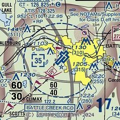
|
CAUTION: Diagram may not be current
 Download PDF
of official airport diagram from the FAA
| Airport distance calculator |
|---|
|
|
| Sunrise and sunset |
|---|
|
Times for 16-Jan-2026
| | Local
(UTC-5) | | Zulu
(UTC) |
|---|
| Morning civil twilight | | 07:37 | | 12:37 |
| Sunrise | | 08:08 | | 13:08 |
| Sunset | | 17:34 | | 22:34 |
| Evening civil twilight | | 18:05 | | 23:05 |
|
| Current date and time |
|---|
| Zulu (UTC) | 17-Jan-2026 00:45:59 |
|---|
| Local (UTC-5) | 16-Jan-2026 19:45:59 |
|---|
|
| METAR |
|---|
| KBTL | 162353Z 21013KT 10SM FEW016 SCT030 OVC050 00/M02 A2960 RMK AO2 SLP034 60000 T00001022 10000 21033 53017
|
KAZO
14nm W | 170028Z 21012KT 10SM SCT018 OVC044 01/M02 A2962 RMK AO2 T00061017
|
KRMY
14nm E | 170035Z AUTO 21008KT 10SM BKN015 BKN021 OVC039 00/M02 A2962 RMK AO2 T00001025
|
|
| TAF |
|---|
| KBTL | 161742Z 1618/1718 20012G18KT 3SM -SN BR OVC015 TEMPO 1618/1620 1 1/2SM -SN BR OVC012 FM162000 22013G21KT 5SM -SHSN BR BKN010 FM162300 22011KT P6SM -SHSN OVC010 FM170100 21011KT P6SM OVC020 FM171300 24011G18KT P6SM OVC025
|
KAZO
14nm W | 161742Z 1618/1718 20012G18KT 4SM -SN BR OVC015 TEMPO 1618/1620 1SM -SN BR OVC012 FM162000 22013G21KT 5SM -SHSN BR BKN010 FM162300 22011KT P6SM -SHSN OVC010 FM170100 21011KT P6SM OVC020 FM171300 24011G18KT P6SM OVC025
|
|
| NOTAMs |
|---|
NOTAMs are issued by the DoD/FAA and will open in a separate window not controlled by AirNav.
|
|


