FAA INFORMATION EFFECTIVE 09 JULY 2026
Location
| FAA Identifier: | AZO |
| Lat/Long: | 42-14-03.8000N 085-33-05.6000W
42-14.063333N 085-33.093333W
42.2343889,-85.5515556
(estimated) |
| Elevation: | 873.9 ft. / 266.4 m (surveyed) |
| Variation: | 03W (1985) |
| From city: | 3 miles SE of KALAMAZOO, MI |
| Time zone: | UTC -4 (UTC -5 during Standard Time) |
| Zip code: | 49002 |
Airport Operations
| Airport use: | Open to the public |
| Activation date: | 04/1940 |
| Control tower: | yes |
| ARTCC: | CHICAGO CENTER |
| FSS: | LANSING FLIGHT SERVICE STATION |
| NOTAMs facility: | AZO (NOTAM-D service available) |
| Attendance: | CONTINUOUS |
| Pattern altitude: | 1673.9 ft. MSL |
| Wind indicator: | lighted |
| Segmented circle: | yes |
| Lights: | WHEN ATCT CLSD ACTVT MALSR RWY 35; REIL RWY 17, 05, & 23; HIRL RWY 17/35; MIRL RWY 05/23 & 09/27 - CTAF. PAPI RWY 17, 35, 05, & 23 OPR CONSLY. |
| Beacon: | white-green (lighted land airport)
ATC-CTL |
| Landing fee: | yes, GA LDG FEE FOR ACFT WITH MAX LDG WT 8000 LB OR GTR. |
| Fire and rescue: | ARFF index B |
| Airline operations: | PPR FOR UNSKED ACR OPS GTR THAN 30 PAX SEATS - CALL AMGR. |
| International operations: | customs landing rights airport |
Airport Communications
| CTAF: | 118.3 |
| UNICOM: | 122.95 |
| ATIS: | 127.25 |
| WX ASOS: | PHONE 269-459-3391 |
| KALAMAZOO GROUND: | 121.9 [0600-2300] |
| KALAMAZOO TOWER: | 118.3 257.875 [0600-2300] |
| GREAT LAKES APPROACH: | 121.2 239.25 ;175-353 270.25 ;354-174 [0530-0000] |
| CHICAGO ARTCC APPROACH: | 119.2 123.8 [0000-0530] |
| GREAT LAKES DEPARTURE: | 121.2 239.25 ;175-353 270.25 ;354-174 [0530-0000] |
| CHICAGO ARTCC DEPARTURE: | 119.2 123.8 [0000-0530] |
| CLEARANCE DELIVERY: | 121.75 121.2 ;WHEN TWR CLSD THRU CHICAGO AR |
| EMERG: | 121.5 243.0 |
| IC: | 121.2 239.25 ;175-353 |
| TRSA: | 121.2 239.25 ;175-353 270.25 ;354-174 |
| WX ASOS at BTL (14 nm E): | PHONE 269-964-0283 |
| WX AWOS-3P at HAI (17 nm S): | 119.975 (269-273-6705) |
- APCH/DEP SVC PRVDD BY CHICAGO ARTCC ON FREQS 127.55/307.175 (GOSHEN RCAG) WHEN GREAT LAKES APCH CTL CLSD.
Nearby radio navigation aids
| VOR radial/distance | | VOR name | | Freq | | Var |
|---|
| VIOr188/33.2 | | VICTORY VOR/DME | | 115.95 | | 04W |
| NDB name | | Hdg/Dist | | Freq | | Var | | ID |
|---|
| AUSTN | | 354/6.3 | | 371 | | 03W | | AZ | .- --.. |
| STURGIS | | 352/25.8 | | 382 | | 04W | | IRS | .. .-. ... |
Airport Services
| Fuel available: | 100LL JET-A |
| Parking: | hangars and tiedowns |
| Airframe service: | MAJOR |
| Powerplant service: | MAJOR |
| Bottled oxygen: | HIGH |
| Bulk oxygen: | HIGH |
Runway Information
Runway 17/35
| Dimensions: | 6502 x 150 ft. / 1982 x 46 m |
| Surface: | asphalt/grooved, in good condition |
| Weight bearing capacity: | | Single wheel: | 85.0 | | Double wheel: | 121.0 | | Double tandem: | 240.0 |
|
| Runway edge lights: | high intensity |
| RUNWAY 17 | | RUNWAY 35 |
| Latitude: | 42-14.482273N | | 42-13.424695N |
| Longitude: | 085-33.104042W | | 085-32.881078W |
| Elevation: | 859.2 ft. | | 868.2 ft. |
| Traffic pattern: | left | | left |
| Runway heading: | 174 magnetic, 171 true | | 354 magnetic, 351 true |
| Declared distances: | TORA:6502 TODA:6502 ASDA:6502 LDA:6502 | | TORA:6502 TODA:6502 ASDA:6502 LDA:6502 |
| Markings: | precision, in good condition | | precision, in good condition |
| Visual slope indicator: | 4-light PAPI on left (3.00 degrees glide path) | | 4-light PAPI on left (3.00 degrees glide path) |
| RVR equipment: | rollout | | touchdown |
| Approach lights: | | | MALSR: 1,400 foot medium intensity approach lighting system with runway alignment indicator lights |
| Runway end identifier lights: | yes | | no |
| Touchdown point: | yes, no lights | | yes, no lights |
| Instrument approach: | | | ILS |
| Obstructions: | 76 ft. trees, 2090 ft. from runway, 750 ft. left of centerline, 24:1 slope to clear | | 18 ft. rr, 758 ft. from runway, 586 ft. right of centerline, 31:1 slope to clear |
Runway 5/23
| Dimensions: | 3438 x 100 ft. / 1048 x 30 m |
| Surface: | asphalt/grooved, in fair condition |
| Weight bearing capacity: | | Single wheel: | 30.0 | | Double wheel: | 45.0 | | Double tandem: | 60.0 |
|
| Runway edge lights: | medium intensity |
| Operational restrictions: | RWY 05/23 NOT AVBL FOR PART 121/PART 380 OPS WITH SKED PAX CARRYING OPS MORE THAN 9 PAX SEATS AND NON-SKED PAX CARRYING OPS MORE THAN 30 PAX SEATS. NO PART 121/PART 380 OPS EXC FOR TAX. |
| RUNWAY 5 | | RUNWAY 23 |
| Latitude: | 42-14.092790N | | 42-14.493508N |
| Longitude: | 085-33.484103W | | 085-32.946052W |
| Elevation: | 873.8 ft. | | 850.9 ft. |
| Traffic pattern: | left | | left |
| Runway heading: | 048 magnetic, 045 true | | 228 magnetic, 225 true |
| Declared distances: | TORA:3438 TODA:3438 ASDA:3438 LDA:3438 | | TORA:3438 TODA:3438 ASDA:3438 LDA:3438 |
| Markings: | nonprecision, in fair condition | | nonprecision, in fair condition |
| Visual slope indicator: | 4-light PAPI on left (3.00 degrees glide path) | | 4-light PAPI on left (3.50 degrees glide path) |
| Runway end identifier lights: | yes | | yes |
| Touchdown point: | yes, no lights | | yes, no lights |
| Obstructions: | 46 ft. pole, 900 ft. from runway, 275 ft. right of centerline, 15:1 slope to clear | | 53 ft. tree, 1050 ft. from runway, 340 ft. left of centerline, 16:1 slope to clear |
Runway 9/27
| Dimensions: | 2800 x 60 ft. / 853 x 18 m |
| Surface: | asphalt, in good condition |
| Weight bearing capacity: | | Single wheel: | 30.0 | | Double wheel: | 60.0 |
|
| Runway edge lights: | medium intensity |
| Operational restrictions: | RWY 09/27 NOT AVBL FOR PART 121/PART 380 OPS WITH SKED PAX CARRYING OPS MORE THAN 9 PAX SEATS AND NON-SKED PAX CARRYING OPS MORE THAN 30 PAX SEATS. |
| RUNWAY 9 | | RUNWAY 27 |
| Latitude: | 42-14.035983N | | 42-14.035393N |
| Longitude: | 085-33.488108W | | 085-32.867793W |
| Elevation: | 872.9 ft. | | 862.7 ft. |
| Traffic pattern: | left | | left |
| Runway heading: | 093 magnetic, 090 true | | 273 magnetic, 270 true |
| Declared distances: | TORA:2800 TODA:2800 ASDA:2800 LDA:2800 | | TORA:2800 TODA:2800 ASDA:2800 LDA:2800 |
| Markings: | basic, in fair condition | | basic, in fair condition |
| Runway end identifier lights: | no | | no |
| Touchdown point: | yes, no lights | | yes, no lights |
| Obstructions: | 84 ft. tree, 1710 ft. from runway, 275 ft. left of centerline, 17:1 slope to clear | | 17 ft. rr, 640 ft. from runway, 25:1 slope to clear |
Airport Ownership and Management from official FAA records
| Ownership: | Publicly-owned |
| Owner: | KALAMAZOO CO
5235 PORTAGE RD
PORTAGE, MI 49002
Phone 269-388-3668 |
| Manager: | CRAIG WILLIAMS, AIRPORT DIRECTOR
5235 PORTAGE RD
PORTAGE, MI 49002
Phone 269-388-3668 |
Additional Remarks
| A39-05/23 | PCR VALUE: 354/F/C/X/T |
| A39-09/27 | PCR VALUE: 66/F/C/X/T |
| A39-17/35 | PCR VALUE: 402/F/C/X/T |
| - | MIGRATORY WATER FOWL ROOSTING AREA 5500 FT APCH END RY 35. BIRDS ON & INVOF ARPT. |
| - | 11C SPB LCTD 3.6 NM SOUTH. ACFT OPRG AT 11C WILL ANNC INTNS ON AZO CTAF. |
| - | PPR FOR UNSKED ACR OPS GTR THAN 175,000 LB MAX TOG. |
| - | FICONS UNMON NOV-APR 0000-0300 & MAY-OCT 0000-0400. |
| - | FOR CUSTOMS CALL 269-965-3349. |
| - | TWYS F & G E OF RY 17/35 RSTRD ACFT LESS THAN 12500 LBS. |
| - | RY 09 & RY 05 APCH ENDS ARE CLOSELY ALIGNED. VERIFY CORRECT RY AND COMPASS HEADING PRIOR TO DEP. |
| - | FOR CD WHEN TWR CLSD CTC GREAT LAKES APCH AT 269-459-3344, WHEN APCH CLSD CTC CHICAGO ARTCC AT 630-906-8921. |
Instrument Procedures
NOTE: All procedures below are presented as PDF files. If you need a reader for these files, you should download the free Adobe Reader.NOT FOR NAVIGATION. Please procure official charts for flight.
FAA instrument procedures published for use from 09 July 2026 at 0901Z to 06 August 2026 at 0900Z.
IAPs - Instrument Approach Procedures |
|---|
| ILS OR LOC RWY 35 | |
download (262KB) |
| RNAV (GPS) RWY 05 | |
download (210KB) |
| RNAV (GPS) RWY 17 **CHANGED** | |
download (246KB) |
| RNAV (GPS) RWY 23 **CHANGED** | |
download (227KB) |
| RNAV (GPS) RWY 35 **CHANGED** | |
download (270KB) |
| NOTE: Special Alternate Minimums apply | |
download (123KB) |
| NOTE: Special Take-Off Minimums/Departure Procedures apply | |
download (122KB) |
Other nearby airports with instrument procedures:
KBTL - Battle Creek Executive Airport at Kellogg Field (14 nm E)
KHAI - Three Rivers Municipal/Dr Haines Airport (17 nm S)
35D - Padgham Field Airport (21 nm NW)
KIRS - Kirsch Municipal Airport (26 nm S)
KRMY - Brooks Field Airport (26 nm E)
|
|

Road maps at:
MapQuest
Bing
Google
| Aerial photo |
|---|
WARNING: Photo may not be current or correct
 Photo by Matthew O'Hern from Kalamazoo, Michigan
Do you have a better or more recent aerial photo of Kalamazoo/Battle Creek International Airport that you would like to share? If so, please send us your photo.
|
| Sectional chart |
|---|
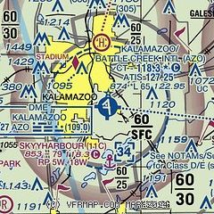
|
CAUTION: Diagram may not be current
 Download PDF
of official airport diagram from the FAA
| Airport distance calculator |
|---|
|
|
| Sunrise and sunset |
|---|
|
Times for 17-Jul-2026
| | Local
(UTC-4) | | Zulu
(UTC) |
|---|
| Morning civil twilight | | 05:49 | | 09:49 |
| Sunrise | | 06:22 | | 10:22 |
| Sunset | | 21:15 | | 01:15 |
| Evening civil twilight | | 21:48 | | 01:48 |
|
| Current date and time |
|---|
| Zulu (UTC) | 18-Jul-2026 00:06:03 |
|---|
| Local (UTC-4) | 17-Jul-2026 20:06:03 |
|---|
|
| METAR |
|---|
| KAZO | 172353Z 18005KT 10SM FU CLR 26/22 A2995 RMK AO2 SLP137 60002 T02610217 10317 20239 58009
|
KBTL
15nm E | 172353Z 22004KT 2 1/2SM FU CLR 26/22 A2996 RMK AO2 SLP139 60006 T02610217 10311 20244 58010
|
KHAI
17nm S | 172355Z AUTO 23003KT 10SM CLR 24/22 A2996 RMK AO2 10316 20239
|
|
| TAF |
|---|
| KAZO | 172054Z 1721/1818 21008KT 1SM TSRA FU BKN020CB FM172300 22006KT 6SM FU SCT030 FM180500 25011G18KT P6SM BKN150
|
KBTL
15nm E | 172101Z 1721/1818 VRB03KT 3/4SM FU VV020 FM172200 21008KT 1SM FU VCTS SCT030CB PROB30 1722/1724 5SM -TSRA BKN030CB FM180200 22006KT 6SM FU SCT030 FM180600 25011G18KT P6SM BKN150
|
|
| NOTAMs |
|---|
NOTAMs are issued by the DoD/FAA and will open in a separate window not controlled by AirNav.
|
|


