FAA INFORMATION EFFECTIVE 09 JULY 2026
Location
| FAA Identifier: | CEW |
| Lat/Long: | 30-46-43.7920N 086-31-19.6060W
30-46.729867N 086-31.326767W
30.7788311,-86.5221128
(estimated) |
| Elevation: | 213.5 ft. / 65.1 m (surveyed) |
| Variation: | 04W (2020) |
| From city: | 3 miles NE of CRESTVIEW, FL |
| Time zone: | UTC -5 (UTC -6 during Standard Time) |
| Zip code: | 32539 |
Airport Operations
| Airport use: | Open to the public |
| Activation date: | 09/1963 |
| Control tower: | no |
| ARTCC: | JACKSONVILLE CENTER |
| FSS: | GAINESVILLE FLIGHT SERVICE STATION |
| NOTAMs facility: | CEW (NOTAM-D service available) |
| Attendance: | 0600-2000 |
| Wind indicator: | lighted |
| Segmented circle: | yes |
| Lights: | ACTVT HIRL RWY 17/35 - CTAF. PAPI RWYS 17 & 35 OPER CONSLY. |
| Beacon: | white-green (lighted land airport)
Operates sunset to sunrise. |
Airport Communications
| CTAF/UNICOM: | 123.075 |
| WX ASOS: | 119.275 (850-682-1237) |
| EGLIN APPROACH: | 124.05 |
| EGLIN DEPARTURE: | 124.05 |
| WX ASOS at 0J4 (19 nm NE): | 124.175 (251-216-1056) |
| WX AWOS-3P at 54J (19 nm E): | 118.725 (850-892-0147) |
Nearby radio navigation aids
| VOR radial/distance | | VOR name | | Freq | | Var |
|---|
| CEWr106/8.6 | | CRESTVIEW VORTAC | | 115.90 | | 03E |
| NDB name | | Hdg/Dist | | Freq | | Var | | ID |
|---|
| KOBRA | | 174/4.5 | | 201 | | 04W | | CE | -.-. . |
Airport Services
| Fuel available: | 100LL JET-A JET-A1+
100LL:FOR FUEL AFT 1900 CALL 850-393-0751. |
| Parking: | tiedowns |
| Airframe service: | MAJOR |
| Powerplant service: | MAJOR |
| Bottled oxygen: | HIGH |
| Bulk oxygen: | HIGH |
Runway Information
Runway 17/35
| Dimensions: | 8006 x 150 ft. / 2440 x 46 m |
| Surface: | asphalt, in fair condition |
| Weight bearing capacity: | | PCN 22 /F/A/W/T | | Single wheel: | 60.0 | | Double wheel: | 120.0 | | Double tandem: | 170.0 |
|
| Runway edge lights: | high intensity |
| RUNWAY 17 | | RUNWAY 35 |
| Latitude: | 30-47.382027N | | 30-46.077710N |
| Longitude: | 086-31.446497W | | 086-31.207055W |
| Elevation: | 213.5 ft. | | 153.6 ft. |
| Traffic pattern: | left | | left |
| Runway heading: | 175 magnetic, 171 true | | 355 magnetic, 351 true |
| Markings: | precision, in good condition | | nonprecision, in good condition |
| Visual slope indicator: | 4-light PAPI on right (3.00 degrees glide path) | | 4-light PAPI on right (3.00 degrees glide path) |
| Touchdown point: | yes, no lights | | yes, no lights |
| Instrument approach: | ILS | | |
| Obstructions: | 41 ft. trees, 1845 ft. from runway, 95 ft. left of centerline, 40:1 slope to clear | | 58 ft. trees, 2195 ft. from runway, 120 ft. left of centerline, 34:1 slope to clear |
Airport Ownership and Management from official FAA records
| Ownership: | Publicly-owned |
| Owner: | OKALOOSA COUNTY
BOARD OF COUNTY COMMISSIONERS, 302 NORTH WILSON ST.
CRESTVIEW, FL 32536
Phone 850-689-5000
FAX: 850-651-7164 |
| Manager: | TRACY STAGE
1701 STATE ROAD 85 NORTH
EGLIN AFB, FL 32542-1413
Phone 850-651-7160
EXT 4. |
Additional Remarks
| A30A-17 | UNLGT OBST IN APCH; 55 FT TREES 1755 FT BFR AER. |
| - | MIL & TRNG TFC ALL QUADRANTS; MEN & EQUIP ON & INVOF SAFETY AREA. |
| - | VFR ARR MNT 122.95. |
| - | NOISE ABATEMENT PROC IN EFCT; DEP MNTN RWY HDG TO 700 FT MSL BFR TURNING. |
| - | WILDLIFE ON & INVOF ARPT; SPCLY AT NIGHT. |
| - | FOR CD IF UNA TO CTC ON FSS FREQ, CTC EGLIN APCH 850-882-9152 OR 850-882-9151. |
Instrument Procedures
NOTE: All procedures below are presented as PDF files. If you need a reader for these files, you should download the free Adobe Reader.NOT FOR NAVIGATION. Please procure official charts for flight.
FAA instrument procedures published for use from 09 July 2026 at 0901Z to 06 August 2026 at 0900Z.
IAPs - Instrument Approach Procedures |
|---|
| ILS OR LOC RWY 17 | |
download (228KB) |
| RNAV (GPS) RWY 17 | |
download (227KB) |
| RNAV (GPS) RWY 35 | |
download (241KB) |
| VOR-A | |
download (230KB) |
| NOTE: Special Alternate Minimums apply | |
download (58KB) |
| NOTE: Special Take-Off Minimums/Departure Procedures apply | |
download (162KB) |
Other nearby airports with instrument procedures:
KEGI - Duke Field (Eglin AF Aux Nr 3) Airport (8 nm S)
KVPS - Eglin Air Force Base/Destin-Fort Walton Beach Airport (18 nm S)
0J4 - Florala Municipal Airport (19 nm NE)
54J - DeFuniak Springs Airport (19 nm E)
KHRT - Hurlburt Field Airport (23 nm S)
|
|

Road maps at:
MapQuest
Bing
Google
| Aerial photo |
|---|
WARNING: Photo may not be current or correct
 Photo by Scott Jackson - PhotosFlorida.com
Photo taken 27-Apr-2010
Photo by Scott Jackson - PhotosFlorida.com
Photo taken 27-Apr-2010
Do you have a better or more recent aerial photo of Bob Sikes Airport that you would like to share? If so, please send us your photo.
|
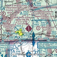
| Sectional chart |
|---|
|
CAUTION: Diagram may not be current

| Airport distance calculator |
|---|
|
|
| Sunrise and sunset |
|---|
|
Times for 19-Jul-2026
| | Local
(UTC-5) | | Zulu
(UTC) |
|---|
| Morning civil twilight | | 05:30 | | 10:30 |
| Sunrise | | 05:57 | | 10:57 |
| Sunset | | 19:48 | | 00:48 |
| Evening civil twilight | | 20:15 | | 01:15 |
|
| Current date and time |
|---|
| Zulu (UTC) | 20-Jul-2026 02:22:41 |
|---|
| Local (UTC-5) | 19-Jul-2026 21:22:41 |
|---|
|
| METAR |
|---|
| KCEW | 200153Z AUTO 00000KT 10SM FEW044 24/23 A2995 RMK AO2 SLP138 T02440233
|
KEGI
9nm S | 200155Z AUTO 00000KT 10SM FEW140 BKN190 25/23 A2992 RMK AO2 LTG DSNT W SLP131 T02450234 $
|
KVPS
19nm S | 200155Z AUTO 03004KT 10SM FEW130 SCT150 26/25 A2990 RMK AO2 LTG DSNT W DZB0055E0058 SLP131 P0000 T02560251 $
|
K0J4
19nm NE | 200158Z AUTO 00000KT 10SM FEW024 FEW043 25/23 A2995 RMK AO2 SLP138 T02500228
|
K54J
19nm E | 200155Z AUTO 00000KT 10SM CLR 24/24 A2994 RMK AO2 LTG DSNT W T02430243
|
|
| TAF |
|---|
KVPS
19nm S | 191700Z 1917/2023 04012KT 9000 -SHRA FEW012 BKN025 QNH2997INS TEMPO 1918/1924 VRB10G25KT 8000 -TSRA BKN025CB BECMG 2000/2001 35003KT 9999 NSW SCT030 BKN080 QNH2988INS BECMG 2015/2016 05009KT 9999 SHRA FEW030 FEW080 BKN110 QNH2987INS TEMPO 2016/2019 06009KT 8000 -TSRA BKN040CB BECMG 2020/2021 07010G25KT 9999 -SHRA BKN040 OVC055 QNH2981INS TX31/1921Z TN25/2011Z
|
|
| NOTAMs |
|---|
NOTAMs are issued by the DoD/FAA and will open in a separate window not controlled by AirNav.
|
|


