FAA INFORMATION EFFECTIVE 11 JUNE 2026
Location
| FAA Identifier: | CTY |
| Lat/Long: | 29-38-07.9000N 083-06-17.1000W
29-38.131667N 083-06.285000W
29.6355278,-83.1047500
(estimated) |
| Elevation: | 42.1 ft. / 12.8 m (surveyed) |
| Variation: | 05W (2010) |
| From city: | 1 mile E of CROSS CITY, FL |
| Time zone: | UTC -4 (UTC -5 during Standard Time) |
| Zip code: | 32628 |
Airport Operations
| Airport use: | Open to the public |
| Activation date: | 04/1940 |
| Control tower: | no |
| ARTCC: | JACKSONVILLE CENTER |
| FSS: | GAINESVILLE FLIGHT SERVICE STATION |
| NOTAMs facility: | GNV (NOTAM-D service available) |
| Attendance: | 0800-1700 |
| Wind indicator: | lighted |
| Segmented circle: | yes |
| Lights: | ACTVT REIL 13 & 31; PAPI RWY 04, 22, 13 & 31; MIRL RWY 04/22 - CTAF. |
| Beacon: | white-green (lighted land airport)
Operates sunset to sunrise. |
Airport Communications
| CTAF/UNICOM: | 122.8 |
| WX AWOS-3PT: | 120.775 (352-498-0221) |
- APCH/DEP SVC PRVDD BY JACKSONVILLE ARTCC ON FREQS 127.8/352.0 (PERRY FOLEY RCAG).
Airport Services
| Fuel available: | 100LL JET-A |
| Parking: | tiedowns |
| Airframe service: | MAJOR |
| Powerplant service: | MAJOR |
| Bottled oxygen: | NONE |
| Bulk oxygen: | NONE |
Runway Information
Runway 4/22
| Dimensions: | 5005 x 75 ft. / 1526 x 23 m |
| Surface: | asphalt, in excellent condition |
| Weight bearing capacity: | | PCN 8 /F/B/Y/T | | Single wheel: | 13.0 |
|
| Runway edge lights: | medium intensity |
| RUNWAY 4 | | RUNWAY 22 |
| Latitude: | 29-38.042077N | | 29-38.639840N |
| Longitude: | 083-06.473387W | | 083-05.821162W |
| Elevation: | 41.7 ft. | | 39.3 ft. |
| Traffic pattern: | left | | left |
| Runway heading: | 049 magnetic, 044 true | | 229 magnetic, 224 true |
| Markings: | nonprecision, in good condition | | nonprecision, in good condition |
| Visual slope indicator: | 2-light PAPI on left (3.00 degrees glide path) | | 2-light PAPI on left (3.00 degrees glide path) |
| Runway end identifier lights: | no | | no |
| Touchdown point: | yes, no lights | | yes, no lights |
| Obstructions: | 55 ft. trees, 1355 ft. from runway, 150 ft. right of centerline, 21:1 slope to clear | | 63 ft. trees, 1270 ft. from runway, 60 ft. left of centerline, 17:1 slope to clear |
Runway 13/31
| Dimensions: | 5001 x 100 ft. / 1524 x 30 m |
| Surface: | asphalt/concrete, in fair condition
FIRST 300 FT RWY 31 CONC. |
| Weight bearing capacity: | | PCN 10 /R/C/W/T | | Single wheel: | 13.0 |
|
| Runway edge lights: | medium intensity |
| Runway edge markings: | RWY 31 MRKGS FADED. |
| RUNWAY 13 | | RUNWAY 31 |
| Latitude: | 29-38.205662N | | 29-37.636532N |
| Longitude: | 083-06.764682W | | 083-06.080893W |
| Elevation: | 41.0 ft. | | 40.6 ft. |
| Traffic pattern: | left | | left |
| Runway heading: | 139 magnetic, 134 true | | 319 magnetic, 314 true |
| Markings: | nonprecision, in poor condition | | nonprecision, in poor condition |
| Visual slope indicator: | 2-light PAPI on left (3.00 degrees glide path) | | 2-light PAPI on left (3.00 degrees glide path) |
| Runway end identifier lights: | yes | | yes |
| Touchdown point: | yes, no lights | | yes, no lights |
| Obstructions: | 56 ft. trees, 1430 ft. from runway, 250 ft. right of centerline, 22:1 slope to clear | | 47 ft. trees, 1800 ft. from runway, 60 ft. right of centerline, 34:1 slope to clear |
Airport Ownership and Management from official FAA records
| Ownership: | Publicly-owned |
| Owner: | DIXIE COUNTY
COUNTY COURTHOUSE, P.O. BOX 2600
CROSS CITY, FL 32628
Phone 352-498-1206
CONTACT PERSON: JOHN JENKINS, 352-498-1426 FAX: 352-498-1207 |
| Manager: | CLINT BEAUCHAMP
508 NE 241 ST, 508 NE 241 ST
CROSS CITY, FL 32628
Phone 352-498-6656
AIRPORT PHYSICAL ADDRESS: 1516 AIRPORT ROAD., CROSS CITY, FL 32628, 352-498-1200 |
Additional Remarks
| - | RY 04/22 HAS TREES IN TRANSITION SFC NORTHWEST. |
| - | FOR CD IF UNA TO CTC ON FSS FREQ, CTC JACKSONVILLE ARTCC AT 904-845-1592. |
Instrument Procedures
NOTE: All procedures below are presented as PDF files. If you need a reader for these files, you should download the free Adobe Reader.NOT FOR NAVIGATION. Please procure official charts for flight.
FAA instrument procedures published for use from 11 June 2026 at 0901Z to 09 July 2026 at 0900z.
IAPs - Instrument Approach Procedures |
|---|
| RNAV (GPS) RWY 31 | |
download (271KB) |
| RNAV (GPS)-A | |
download (224KB) |
| RNAV (GPS)-B | |
download (200KB) |
| NOTE: Special Alternate Minimums apply | |
download (149KB) |
| NOTE: Special Take-Off Minimums/Departure Procedures apply | |
download (162KB) |
Other nearby airports with instrument procedures:
KFPY - Perry-Foley Airport (36 nm NW)
X60 - Williston Regional Airport (37 nm SE)
24J - Suwannee County Airport (40 nm N)
KLCQ - Lake City Gateway Airport (43 nm NE)
KGNV - Gainesville Regional Airport (44 nm E)
|
|

Road maps at:
MapQuest
Bing
Google
| Aerial photo |
|---|
WARNING: Photo may not be current or correct
 Photo by Bill Fusselman
Photo taken 02-Oct-2011
looking southwest.
Photo by Bill Fusselman
Photo taken 02-Oct-2011
looking southwest.
Do you have a better or more recent aerial photo of Cross City Airport that you would like to share? If so, please send us your photo.
|
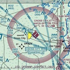
| Sectional chart |
|---|
|
| Airport distance calculator |
|---|
|
|
| Sunrise and sunset |
|---|
|
Times for 03-Jul-2026
| | Local
(UTC-4) | | Zulu
(UTC) |
|---|
| Morning civil twilight | | 06:10 | | 10:10 |
| Sunrise | | 06:38 | | 10:38 |
| Sunset | | 20:36 | | 00:36 |
| Evening civil twilight | | 21:03 | | 01:03 |
|
| Current date and time |
|---|
| Zulu (UTC) | 03-Jul-2026 23:47:49 |
|---|
| Local (UTC-4) | 03-Jul-2026 19:47:49 |
|---|
|
| TAF |
|---|
KGNV
43nm E | 032152Z 0322/0418 07007KT P6SM VCTS SCT050CB FM040000 09004KT P6SM FEW060 SCT150 BKN250 FM041700 04007KT P6SM VCTS SCT030CB BKN250
|
|
| NOTAMs |
|---|
NOTAMs are issued by the DoD/FAA and will open in a separate window not controlled by AirNav.
|
|


