FAA INFORMATION EFFECTIVE 25 DECEMBER 2025
Location
| FAA Identifier: | DRI |
| Lat/Long: | 30-49-54.2020N 093-20-23.6960W
30-49.903367N 093-20.394933W
30.8317228,-93.3399156
(estimated) |
| Elevation: | 201.8 ft. / 61.5 m (surveyed) |
| Variation: | 04E (1990) |
| From city: | 3 miles SW of DE RIDDER, LA |
| Time zone: | UTC -6 (UTC -5 during Daylight Saving Time) |
| Zip code: | 70634 |
Airport Operations
| Airport use: | Open to the public |
| Activation date: | 04/1940 |
| Control tower: | no |
| ARTCC: | HOUSTON CENTER |
| FSS: | DE RIDDER FLIGHT SERVICE STATION |
| NOTAMs facility: | DRI (NOTAM-D service available) |
| Attendance: | MON-FRI 0800-1700
FOR ATTENDANT OTHER TIMES CALL 337-401-2967. |
| Pattern altitude: | 1201.8 ft. MSL |
| Wind indicator: | lighted |
| Segmented circle: | no |
| Lights: | REIL RWY 18 AND MIRL RWY 18/36 PRESET LOW INTST DUSK-DAWN; TO INCR INTST ACTVT - CTAF. |
| Beacon: | white-green (lighted land airport)
Operates sunset to sunrise. |
Airport Communications
| CTAF/UNICOM: | 122.8 |
| WX AWOS-3PT: | 118.225 (337-463-8278) |
| POLK APPROACH: | 123.7 |
| POLK DEPARTURE: | 123.7 |
| WX ASOS at POE (15 nm NE): | PHONE 727-780-1210 |
Nearby radio navigation aids
| VOR radial/distance | | VOR name | | Freq | | Var |
|---|
| FXUr198/(17.9) | | POLK VOR | | 108.40 | | 02E |
| NDB name | | Hdg/Dist | | Freq | | Var | | ID |
|---|
| SULPHUR | | 002/38.2 | | 278 | | 04E | | AUR | .- ..- .-. |
Airport Services
| Fuel available: | 100LL JET-A
100LL:100LL AVBL 24 HRS SELF SERVICE WITH CREDIT CARD. FOR JET A AFT HRS & HOLS CALL 337-401-2967. |
| Parking: | hangars and tiedowns |
| Airframe service: | MINOR |
| Powerplant service: | MINOR |
| Bottled oxygen: | NONE |
| Bulk oxygen: | NONE |
Runway Information
Runway 18/36
| Dimensions: | 5494 x 100 ft. / 1675 x 30 m |
| Surface: | asphalt/concrete/aggregate friction seal coat, in good condition |
| Weight bearing capacity: | |
| Runway edge lights: | medium intensity |
| Runway edge markings: | RUNWAY 36 MARKINGS FADED |
| RUNWAY 18 | | RUNWAY 36 |
| Latitude: | 30-50.279965N | | 30-49.373698N |
| Longitude: | 093-20.268090W | | 093-20.257583W |
| Elevation: | 201.1 ft. | | 196.7 ft. |
| Traffic pattern: | left | | left |
| Runway heading: | 175 magnetic, 179 true | | 355 magnetic, 359 true |
| Markings: | nonprecision, in poor condition | | nonprecision, in poor condition |
| Visual slope indicator: | 4-light PAPI on right (3.00 degrees glide path) | | 4-light PAPI on left (3.00 degrees glide path) |
| Approach lights: | | | ODALS: omnidirectional approach lighting system |
| Runway end identifier lights: | yes | | no |
| Touchdown point: | yes, no lights | | yes, no lights |
| Instrument approach: | | | LOCALIZER |
| Obstructions: | 95 ft. trees, 2437 ft. from runway, 23:1 slope to clear | | 74 ft. trees, 2169 ft. from runway, 226 ft. right of centerline, 26:1 slope to clear |
Runway 14/32
| Dimensions: | 4218 x 60 ft. / 1286 x 18 m |
| Surface: | asphalt, in good condition |
| RUNWAY 14 | | RUNWAY 32 |
| Latitude: | 30-50.246655N | | 30-49.759432N |
| Longitude: | 093-20.854830W | | 093-20.279237W |
| Elevation: | 191.5 ft. | | 192.8 ft. |
| Traffic pattern: | left | | left |
| Runway heading: | 130 magnetic, 134 true | | 310 magnetic, 314 true |
| Displaced threshold: | 454 ft. | | no |
| Markings: | basic, in fair condition | | basic, in fair condition |
| Touchdown point: | yes, no lights | | yes, no lights |
| Obstructions: | 81 ft. trees, 1426 ft. from runway, 163 ft. right of centerline, 15:1 slope to clear
APCH SLP 20:1 TO DSPLCD THR. | | 65 ft. trees, 1635 ft. from runway, 114 ft. left of centerline, 22:1 slope to clear |
Airport Ownership and Management from official FAA records
| Ownership: | Publicly-owned |
| Owner: | BEAUREGARD PARISH
1220 1ST AVE
DERIDDER, LA 70634
Phone 337-463-8250 |
| Manager: | SAM LACK
1220 1ST AVE
DERIDDER, LA 70634
Phone 337-463-8250 |
Additional Remarks
| - | FOR CD IF UNA TO CTC ON FSS FREQ, CTC POLK APCH AT 337-531-2352. |
Instrument Procedures
NOTE: All procedures below are presented as PDF files. If you need a reader for these files, you should download the free Adobe Reader.NOT FOR NAVIGATION. Please procure official charts for flight.
FAA instrument procedures published for use from 25 December 2025 at 0901z to 22 January 2026 at 0900z.
IAPs - Instrument Approach Procedures |
|---|
| RNAV (GPS) RWY 18 | |
download (214KB) |
| RNAV (GPS) RWY 36 | |
download (239KB) |
| NOTE: Special Alternate Minimums apply | |
download (159KB) |
| NOTE: Special Take-Off Minimums/Departure Procedures apply | |
download (116KB) |
Other nearby airports with instrument procedures:
KPOE - Maks Army Air Field (15 nm NE)
L39 - Leesville Airport (20 nm N)
5R8 - De Quincy Industrial Airpark (24 nm S)
KACP - Allen Parish Airport (34 nm E)
KJAS - Jasper County Airport-Bell Field (36 nm W)
|
|

Road maps at:
MapQuest
Bing
Google
| Aerial photo |
|---|
WARNING: Photo may not be current or correct
 Photo taken 11-Apr-2015
looking northwest.
Photo taken 11-Apr-2015
looking northwest.
Do you have a better or more recent aerial photo of Beauregard Regional Airport that you would like to share? If so, please send us your photo.
|
| Sectional chart |
|---|
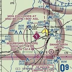
|
| Airport distance calculator |
|---|
|
|
| Sunrise and sunset |
|---|
|
Times for 14-Jan-2026
| | Local
(UTC-6) | | Zulu
(UTC) |
|---|
| Morning civil twilight | | 06:47 | | 12:47 |
| Sunrise | | 07:13 | | 13:13 |
| Sunset | | 17:32 | | 23:32 |
| Evening civil twilight | | 17:58 | | 23:58 |
|
| Current date and time |
|---|
| Zulu (UTC) | 14-Jan-2026 17:40:36 |
|---|
| Local (UTC-6) | 14-Jan-2026 11:40:36 |
|---|
|
| METAR |
|---|
| KDRI | 141715Z AUTO 30008KT 10SM SCT130 BKN160 14/07 A2998 RMK AO2 T01440074 $
|
|
| TAF |
|---|
KPOE
26nm NE | 141500Z 1415/1521 26009KT 9999 SKC QNH2994INS BECMG 1416/1417 30012G18KT 9999 FEW150 SCT250 QNH2993INS BECMG 1418/1419 32012G20KT 9999 SKC QNH2993INS BECMG 1419/1420 33015G25KT 9999 FEW050 QNH2992INS BECMG 1500/1501 34012G20KT 9999 SCT050 QNH3002INS BECMG 1503/1504 34012G20KT 9999 SKC QNH3010INS BECMG 1507/1508 33009KT 9999 SKC QNH3016INS BECMG 1515/1516 33010G15KT 9999 SKC QNH3004INS TX18/1421Z TN01/1512Z
|
|
| NOTAMs |
|---|
NOTAMs are issued by the DoD/FAA and will open in a separate window not controlled by AirNav.
|
|

