FAA INFORMATION EFFECTIVE 14 MAY 2026
Location
| FAA Identifier: | DYA |
| Lat/Long: | 32-27-49.8000N 087-57-14.6000W
32-27.830000N 087-57.243333W
32.4638333,-87.9540556
(estimated) |
| Elevation: | 111.7 ft. / 34.0 m (surveyed) |
| Variation: | 02W (2010) |
| From city: | 6 miles SW of DEMOPOLIS, AL |
| Time zone: | UTC -5 (UTC -6 during Standard Time) |
| Zip code: | 36732 |
Airport Operations
| Airport use: | Open to the public |
| Activation date: | 10/1943 |
| Control tower: | no |
| ARTCC: | MEMPHIS CENTER |
| FSS: | ANNISTON FLIGHT SERVICE STATION |
| NOTAMs facility: | ANB (NOTAM-D service available) |
| Attendance: | MON-SAT 0800-1700
FOR ARPT ATTENDANT AFT HRS CALL 334-289-0455. |
| Wind indicator: | lighted |
| Segmented circle: | no |
| Lights: | ACTVT PAPI RWY 04 & 22; MIRL RWY 04/22 - CTAF. |
| Beacon: | white-green (lighted land airport)
Operates sunset to sunrise. |
Airport Communications
| CTAF/UNICOM: | 122.8 |
| WX AWOS-3P: | 119.475 |
| MERIDIAN APPROACH: | 121.275 |
| MERIDIAN DEPARTURE: | 121.275 |
- APCH/DEP SVC PRVDD BY ATLANTA ARTCC ON FREQS 132.25/263.025 (UNIONTOWN RCAG) WHEN MERIDIAN APCH CTL CLSD.
Airport Services
| Fuel available: | 100LL JET-A+ |
| Parking: | hangars and tiedowns |
| Airframe service: | MINOR |
| Powerplant service: | MINOR |
| Bottled oxygen: | NONE |
| Bulk oxygen: | NONE |
Runway Information
Runway 4/22
| Dimensions: | 5002 x 100 ft. / 1525 x 30 m
20 FT SHOULDERS ON BOTH SIDES OF RWY. |
| Surface: | asphalt, in fair condition |
| Weight bearing capacity: | | Single wheel: | 30.0 | | Double wheel: | 38.0 | | Double tandem: | 60.0 |
|
| Runway edge lights: | medium intensity |
| RUNWAY 4 | | RUNWAY 22 |
| Latitude: | 32-27.526657N | | 32-28.132202N |
| Longitude: | 087-57.573605W | | 087-56.912793W |
| Elevation: | 111.7 ft. | | 105.3 ft. |
| Traffic pattern: | left | | left |
| Runway heading: | 045 magnetic, 043 true | | 225 magnetic, 223 true |
| Markings: | nonprecision, in good condition | | nonprecision, in good condition |
| Visual slope indicator: | 2-light PAPI on right (3.25 degrees glide path) | | 2-light PAPI on left (3.25 degrees glide path) |
| Touchdown point: | yes, no lights | | yes, no lights |
| Obstructions: | 16 ft. tree, 430 ft. from runway, 221 ft. left of centerline, 14:1 slope to clear | | 25 ft. tree, 481 ft. from runway, 265 ft. right of centerline, 11:1 slope to clear |
Airport Ownership and Management from official FAA records
| Ownership: | Publicly-owned |
| Owner: | CITY OF DEMOPOLIS
PO BOX 580
DEMOPOLIS, AL 36732
Phone 334-289-0577 |
| Manager: | JASON PENDERGRASS
744 BOYKIN FIELD ROAD
DEMOPOLIS, AL 36732
Phone 334-289-0455 |
Additional Remarks
| - | DEER ON AND INVOF ARPT. |
| - | FOR CD CTC MERIDIAN APCH 601-679-3691, WHEN MERIDIAN APCH CLSD CTC ATLANTA ARTCC AT 770-210-7692. |
Instrument Procedures
NOTE: All procedures below are presented as PDF files. If you need a reader for these files, you should download the free Adobe Reader.NOT FOR NAVIGATION. Please procure official charts for flight.
FAA instrument procedures published for use from 14 May 2026 at 0901Z to 11 June 2026 at 0900Z.
IAPs - Instrument Approach Procedures |
|---|
| RNAV (GPS) RWY 04 | |
download (251KB) |
| RNAV (GPS) RWY 22 | |
download (276KB) |
| NOTE: Special Alternate Minimums apply | |
download (49KB) |
| NOTE: Special Take-Off Minimums/Departure Procedures apply | |
download |
Other nearby airports with instrument procedures:
7A0 - Greensboro Municipal Airport (20 nm NE)
09A - Butler/Choctaw County Airport (22 nm SW)
A08 - Vaiden Field Airport (29 nm E)
KNMM - Meridian Naval Air Station (Mc Cain Field) Airport (31 nm W)
KAIV - George Downer Airport (40 nm N)
|
|

Road maps at:
MapQuest
Bing
Google
| Aerial photo |
|---|
WARNING: Photo may not be current or correct
 Photo by AirNav, LLC
Photo taken 14-Oct-2010
looking southwest.
Photo by AirNav, LLC
Photo taken 14-Oct-2010
looking southwest.
Do you have a better or more recent aerial photo of Demopolis Regional Airport that you would like to share? If so, please send us your photo.
|
| Sectional chart |
|---|
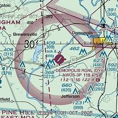
|
| Airport distance calculator |
|---|
|
|
| Sunrise and sunset |
|---|
|
Times for 02-Jun-2026
| | Local
(UTC-5) | | Zulu
(UTC) |
|---|
| Morning civil twilight | | 05:18 | | 10:18 |
| Sunrise | | 05:46 | | 10:46 |
| Sunset | | 19:53 | | 00:53 |
| Evening civil twilight | | 20:22 | | 01:22 |
|
| Current date and time |
|---|
| Zulu (UTC) | 02-Jun-2026 21:25:06 |
|---|
| Local (UTC-5) | 02-Jun-2026 16:25:06 |
|---|
|
| TAF |
|---|
KNMM
31nm W | 021500Z 0215/0315 VRB05KT 9999 VCSH FEW015 FEW065 SCT130 BKN250 QNH2997INS BECMG 0217/0219 34007KT 9999 VCTS SCT030 SCT060 BKN200 QNH2995INS TEMPO 0219/0301 VRB15G30KT 6000 TSRA BKN020CB FM030200 VRB05KT 9999 SCT040 BKN060 QNH2999INS TEMPO 0307/0313 3200 BR BKN010 TX32/0221Z TN19/0310Z FN20088
|
|
| NOTAMs |
|---|
NOTAMs are issued by the DoD/FAA and will open in a separate window not controlled by AirNav.
|
|

