FAA INFORMATION EFFECTIVE 09 JULY 2026
Location
| FAA Identifier: | EDU |
| Lat/Long: | 38-31-53.2640N 121-47-11.2700W
38-31.887733N 121-47.187833W
38.5314622,-121.7864639
(estimated) |
| Elevation: | 69.5 ft. / 21.2 m (surveyed) |
| Variation: | 14E (2010) |
| From city: | 2 miles W of DAVIS, CA |
| Time zone: | UTC -7 (UTC -8 during Standard Time) |
| Zip code: | 95616 |
Airport Operations
| Airport use: | Open to the public |
| Activation date: | 06/1946 |
| Control tower: | no |
| ARTCC: | OAKLAND CENTER |
| FSS: | RANCHO MURIETA FLIGHT SERVICE STATION |
| NOTAMs facility: | RIU (NOTAM-D service available) |
| Attendance: | MON-FRI 0800-1200 |
| Pattern altitude: | 869.5 ft. MSL |
| Wind indicator: | lighted |
| Segmented circle: | yes |
| Lights: | ACTVT REIL RWY 17 & 35; PAPI RWY 17 & 35; MIRL RWY 17/35 - CTAF. |
| Beacon: | white-green (lighted land airport)
Operates sunset to sunrise. |
Airport Communications
| CTAF/UNICOM: | 123.075 |
| WX AWOS-3: | 119.025 (530-754-6839) |
| TRAVIS APPROACH: | 126.6 |
| TRAVIS DEPARTURE: | 126.6 |
| WX AWOS-3P at DWA (4 nm NW): | 125.775 (530-750-2759) |
| WX ASOS at VCB (12 nm SW): | 134.75 (707-240-8032) |
| WX ASOS at SMF (13 nm NE): | PHONE 916-649-3996 |
| WX ASOS at SAC (14 nm E): | PHONE 916-421-0923 |
| WX AWOS-3 at MCC (20 nm NE): | 125.975 (916-641-1272) |
Nearby radio navigation aids
| VOR radial/distance | | VOR name | | Freq | | Var |
|---|
| SACr279/12.2 | | SACRAMENTO VORTAC | | 115.20 | | 17E |
| MCCr229/19.7 | | MC CLELLAN VOR/DME | | 109.20 | | 17E |
| CCRr006/31.6 | | CONCORD VOR/DME | | 117.00 | | 17E |
| ILAr143/34.3 | | WILLIAMS VORTAC | | 114.40 | | 18E |
| SGDr036/34.8 | | SCAGGS ISLAND VORTAC | | 112.10 | | 17E |
| MYVr180/35.5 | | MARYSVILLE VOR/DME | | 110.80 | | 16E |
Airport Services
| Fuel available: | 100LL
100LL:FUEL SELF-SERVICE AVBL 24 HRS. |
| Parking: | tiedowns |
| Airframe service: | MAJOR |
| Powerplant service: | MAJOR |
| Bottled oxygen: | NONE |
| Bulk oxygen: | NONE |
Runway Information
Runway 17/35
| Dimensions: | 3176 x 60 ft. / 968 x 18 m |
| Surface: | asphalt, in excellent condition |
| Weight bearing capacity: | | Single wheel: | OPNS LTD TO ACFT 12500 LBS OR LESS BY ARPT OWNER. |
|
| Runway edge lights: | medium intensity |
| RUNWAY 17 | | RUNWAY 35 |
| Latitude: | 38-32.149295N | | 38-31.626160N |
| Longitude: | 121-47.183420W | | 121-47.192248W |
| Elevation: | 62.0 ft. | | 68.8 ft. |
| Traffic pattern: | left | | left |
| Runway heading: | 167 magnetic, 181 true | | 347 magnetic, 001 true |
| Markings: | nonprecision, in good condition | | basic, in good condition |
| Visual slope indicator: | 2-light PAPI on left (3.25 degrees glide path) | | 2-light PAPI on left (3.25 degrees glide path) |
| Runway end identifier lights: | yes | | yes |
| Touchdown point: | yes, no lights | | yes, no lights |
| Obstructions: | 40 ft. tree, 1113 ft. from runway, 246 ft. left of centerline, 22:1 slope to clear | | 61 ft. trees, 1431 ft. from runway, 221 ft. left of centerline, 20:1 slope to clear |
Airport Ownership and Management from official FAA records
| Ownership: | Publicly-owned |
| Owner: | UNIVERSITY OF CALIFORNIA
OFFICE OF ADMIN & RESOURCE MGT, TB206
DAVIS, CA 95616
Phone 530-752-0100 |
| Manager: | PERRY H EGGLESTON
TRANSP & PARKING SERVICES, 1 SHIELDS AVE
DAVIS, CA 95616-8724
Phone 530-752-5435 |
Additional Remarks
| - | 65 FT TREES LCTD S SIDE OF CREEK 1257 FT FM THR RWY 35. |
| - | TREES +40 FT, W SIDE OF RWY NEAR RWY 17 THR. |
| - | NOISE ABATEMENT, NOISE SENSITIVE AREA N OF ARPT. |
| - | AFTER HRS EMERG: UC DAVIS POLICE 530-752-1230. AFTER HRS NON-EMERG: UC DAVIS POLICE 530-752-1727. |
| - | CAUTION: REMOTE CTL ACFT WI AREA DEFINED AS 0.5 NM RAD OF 3835N/12142W (5 NM NE EDU), SFC - 1200 FT AGL, SR-SS. |
| - | FOR CD CTC OAKLAND ARTCC AT 510-745-3380. |
Instrument Procedures
NOTE: All procedures below are presented as PDF files. If you need a reader for these files, you should download the free Adobe Reader.NOT FOR NAVIGATION. Please procure official charts for flight.
FAA instrument procedures published for use from 09 July 2026 at 0901Z to 06 August 2026 at 0900Z.
IAPs - Instrument Approach Procedures |
|---|
| RNAV (GPS) RWY 17 | |
download (186KB) |
| RNAV (GPS) RWY 35 | |
download (209KB) |
| NOTE: Special Alternate Minimums apply | |
download (139KB) |
| NOTE: Special Take-Off Minimums/Departure Procedures apply | |
download (128KB) |
Other nearby airports with instrument procedures:
KDWA - Yolo County Airport (4 nm NW)
O41 - Watts-Woodland Airport (9 nm NW)
KVCB - Nut Tree Airport (12 nm SW)
KSMF - Sacramento International Airport (13 nm NE)
KSAC - Sacramento Executive Airport (14 nm E)
KSUU - Travis Air Force Base (17 nm S)
KMCC - Mc Clellan Airfield (20 nm NE)
|
|

Road maps at:
MapQuest
Bing
Google
| Aerial photo |
|---|
WARNING: Photo may not be current or correct

Do you have a better or more recent aerial photo of University Airport that you would like to share? If so, please send us your photo.
|
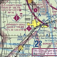
| Sectional chart |
|---|
|
| Airport distance calculator |
|---|
|
|
| Sunrise and sunset |
|---|
|
Times for 24-Jul-2026
| | Local
(UTC-7) | | Zulu
(UTC) |
|---|
| Morning civil twilight | | 05:33 | | 12:33 |
| Sunrise | | 06:03 | | 13:03 |
| Sunset | | 20:24 | | 03:24 |
| Evening civil twilight | | 20:54 | | 03:54 |
|
| Current date and time |
|---|
| Zulu (UTC) | 24-Jul-2026 12:03:11 |
|---|
| Local (UTC-7) | 24-Jul-2026 05:03:11 |
|---|
|
| METAR |
|---|
| KEDU | 241200Z AUTO 00000KT 10SM 14/14 A2989 RMK AO1
|
KDWA
4nm NW | 241155Z AUTO 00000KT 10SM CLR 15/14 A2990 RMK AO2
|
KVCB
12nm SW | 241153Z AUTO 24007KT 10SM CLR 17/12 A2988 RMK AO2 SLP117 T01670117 10222 20167 53001
|
KSMF
13nm NE | 241153Z 15006KT 10SM CLR 17/13 A2988 RMK AO2 SLP117 T01670133 10206 20167 56002
|
KSAC
14nm E | 241153Z AUTO 14004KT 10SM CLR 16/13 A2989 RMK AO2 SLP123 T01610128 10194 20161 55001
|
KSUU
17nm S | 240955Z AUTO 22019G26KT 10SM CLR 17/13 A2986 RMK AO2 PK WND 21026/51 SLP117 T01650128 $
|
KMCC
20nm NE | 241155Z AUTO 15008KT 10SM CLR 17/13 A2989 RMK AO2
|
|
| TAF |
|---|
KSMF
13nm NE | 240520Z 2406/2506 15009KT P6SM SKC FM241400 VRB05KT P6SM SKC FM250000 19011KT P6SM SKC
|
KSAC
14nm E | 240520Z 2406/2506 17006KT P6SM SKC FM241000 VRB05KT P6SM SKC FM242300 22009KT P6SM SKC
|
KSUU
17nm S | 240255Z 2403/2509 23015G25KT 9999 SKC QNH2986INS BECMG 2410/2411 23012G18KT 9999 SKC QNH2991INS TEMPO 2412/2416 SCT020 BECMG 2418/2419 23015G25KT 9999 SKC QNH2985INS TX31/2500Z TN16/2414Z
|
KMCC
20nm NE | 240520Z 2406/2506 15008KT P6SM SKC FM241600 VRB06KT P6SM SKC FM250000 20010KT P6SM SKC
|
|
| NOTAMs |
|---|
NOTAMs are issued by the DoD/FAA and will open in a separate window not controlled by AirNav.
|
|

