FAA INFORMATION EFFECTIVE 09 JULY 2026
Location
| FAA Identifier: | EQA |
| Lat/Long: | 37-46-26.8000N 096-49-03.8000W
37-46.446667N 096-49.063333W
37.7741111,-96.8177222
(estimated) |
| Elevation: | 1379.3 ft. / 420.4 m (surveyed) |
| Variation: | 05E (2000) |
| From city: | 3 miles SE of EL DORADO, KS |
| Time zone: | UTC -5 (UTC -6 during Standard Time) |
| Zip code: | 67042 |
Airport Operations
| Airport use: | Open to the public |
| Activation date: | 02/1944 |
| Control tower: | no |
| ARTCC: | KANSAS CITY CENTER |
| FSS: | WICHITA FLIGHT SERVICE STATION |
| NOTAMs facility: | ICT (NOTAM-D service available) |
| Attendance: | MON-FRI 0700-1500 |
| Wind indicator: | lighted |
| Segmented circle: | yes |
| Lights: | ACTVT PAPI RWY 04 & 22, 15 & 33; HIRL 4/22 AND 15/33 - CTAF. |
| Beacon: | white-green (lighted land airport)
Operates sunset to sunrise. |
Airport Communications
| CTAF/UNICOM: | 122.8 |
| WX AWOS-3P: | 120.875 (316-322-8095) |
| WICHITA APPROACH: | 134.8 |
| WICHITA DEPARTURE: | 134.8 |
| WX AWOS-3P at 3AU (14 nm SW): | 124.175 (316-733-6696) |
| WX ASOS at AAO (19 nm W): | 134.025 (316-636-2541) |
| WX AWOS-3PT at BEC (19 nm W): | 119.45 (316-515-7116) |
Nearby radio navigation aids
| VOR radial/distance | | VOR name | | Freq | | Var |
|---|
| ICTr080/36.4 | | WICHITA VORTAC | | 113.80 | | 07E |
Airport Services
| Fuel available: | 100LL JET-A MOGAS
100LL:100 LL, JET A, MOGAS 24 HR SELF-SERVE. |
| Parking: | hangars and tiedowns |
| Airframe service: | MAJOR |
| Powerplant service: | MAJOR |
| Bottled oxygen: | NONE |
| Bulk oxygen: | NONE |
Runway Information
Runway 4/22
| Dimensions: | 4204 x 75 ft. / 1281 x 23 m |
| Surface: | asphalt, in fair condition |
| Weight bearing capacity: | | Single wheel: | 18.0 | | Double wheel: | 23.0 |
|
| Runway edge lights: | high intensity |
| RUNWAY 4 | | RUNWAY 22 |
| Latitude: | 37-46.213762N | | 37-46.717103N |
| Longitude: | 096-49.386525W | | 096-48.787055W |
| Elevation: | 1375.8 ft. | | 1378.2 ft. |
| Traffic pattern: | left | | left |
| Runway heading: | 038 magnetic, 043 true | | 218 magnetic, 223 true |
| Markings: | nonprecision, in good condition | | nonprecision, in good condition |
| Visual slope indicator: | 2-light PAPI on left (3.00 degrees glide path) | | 2-light PAPI on left (3.00 degrees glide path) |
| Touchdown point: | yes, no lights | | yes, no lights |
| Obstructions: | 10 ft. trees, 290 ft. from runway, 175 ft. left of centerline, 9:1 slope to clear
15 FT TREES, 60-200 FT DSTC, 215 FT L. | | none |
Runway 15/33
| Dimensions: | 4200 x 75 ft. / 1280 x 23 m |
| Surface: | concrete, in good condition |
| Weight bearing capacity: | | Single wheel: | 12.5 | | Double wheel: | 12.5 |
|
| Runway edge lights: | high intensity |
| RUNWAY 15 | | RUNWAY 33 |
| Latitude: | 37-46.750788N | | 37-46.105217N |
| Longitude: | 096-49.197643W | | 096-48.883577W |
| Elevation: | 1373.4 ft. | | 1379.3 ft. |
| Traffic pattern: | left | | left |
| Runway heading: | 154 magnetic, 159 true | | 334 magnetic, 339 true |
| Markings: | nonprecision, in good condition | | nonprecision, in good condition |
| Visual slope indicator: | 2-light PAPI on left (3.00 degrees glide path) | | 2-light PAPI on left (3.00 degrees glide path) |
| Touchdown point: | yes, no lights | | yes, no lights |
| Obstructions: | 40 ft. trees, 1160 ft. from runway, 24:1 slope to clear | | none |
Airport Ownership and Management from official FAA records
| Ownership: | Publicly-owned |
| Owner: | CITY OF EL DORADO
220 E 1ST AVE
EL DORADO, KS 67042
Phone 316-321-9100 |
| Manager: | LARRY ARNOLD
220 E 1ST AVE
EL DORADO, KS 67042
Phone 316-321-1327 |
Additional Remarks
| - | AVOID FLT OVR PRISON N OF ARPT. |
| - | FOR CD CTC WICHITA APCH AT 316-350-1520. |
| - | AFT HRS PHONE NMBR POSTED AT ARPT. |
| - | COURTESY CAR. |
| - | TERMINAL ACCESS AFT HRS CTAF. |
| - | PHYS ADR 1485 S.E. 30TH. |
Instrument Procedures
NOTE: All procedures below are presented as PDF files. If you need a reader for these files, you should download the free Adobe Reader.NOT FOR NAVIGATION. Please procure official charts for flight.
FAA instrument procedures published for use from 09 July 2026 at 0901Z to 06 August 2026 at 0900Z.
IAPs - Instrument Approach Procedures |
|---|
| RNAV (GPS) RWY 04 | |
download (231KB) |
| RNAV (GPS) RWY 15 | |
download (241KB) |
| RNAV (GPS) RWY 22 | |
download (220KB) |
| RNAV (GPS) RWY 33 | |
download (230KB) |
| NOTE: Special Take-Off Minimums/Departure Procedures apply | |
download (360KB) |
Other nearby airports with instrument procedures:
3AU - Augusta Municipal Airport (14 nm SW)
1K1 - Lloyd Stearman Field Airport (14 nm W)
KAAO - Colonel James Jabara Airport (19 nm W)
KBEC - Beech Factory Airport (19 nm W)
K50 - Cook Airfield (21 nm SW)
|
|

Road maps at:
MapQuest
Bing
Google
| Aerial photo |
|---|
WARNING: Photo may not be current or correct
 Photo by cshayes
Photo taken 07-Aug-2011
looking north.
Photo by cshayes
Photo taken 07-Aug-2011
looking north.
Do you have a better or more recent aerial photo of El Dorado/Capt Jack Thomas Memorial Airport that you would like to share? If so, please send us your photo.
|
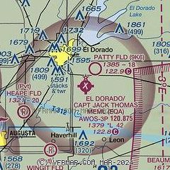
| Sectional chart |
|---|
|
| Airport distance calculator |
|---|
|
|
| Sunrise and sunset |
|---|
|
Times for 21-Jul-2026
| | Local
(UTC-5) | | Zulu
(UTC) |
|---|
| Morning civil twilight | | 05:53 | | 10:53 |
| Sunrise | | 06:23 | | 11:23 |
| Sunset | | 20:44 | | 01:44 |
| Evening civil twilight | | 21:14 | | 02:14 |
|
| Current date and time |
|---|
| Zulu (UTC) | 21-Jul-2026 22:28:45 |
|---|
| Local (UTC-5) | 21-Jul-2026 17:28:45 |
|---|
|
| METAR |
|---|
| KEQA | 212215Z AUTO 06011G16KT 10SM CLR 36/13 A2997 RMK AO2
|
K3AU
14nm SW | 212215Z AUTO 04011G16KT 10SM CLR 35/13 A2997 RMK AO2
|
KAAO
19nm W | 212154Z AUTO 07011G18KT 10SM CLR 36/14 A2997 RMK AO2 PK WND 06027/2100 SLP128 T03610139
|
KBEC
19nm W | 212215Z AUTO 06013KT 10SM CLR 35/13 A2997 RMK AO2 T03540132
|
|
| TAF |
|---|
KIAB
23nm SW | 211800Z 2118/2224 06010G18KT 9999 FEW200 QNH2991INS BECMG 2201/2202 05009KT 9999 SKC QNH2995INS BECMG 2214/2215 09010G15KT 9999 SKC QNH3004INS TX38/2121Z TN21/2212Z
|
|
| NOTAMs |
|---|
NOTAMs are issued by the DoD/FAA and will open in a separate window not controlled by AirNav.
|
|

