FAA INFORMATION EFFECTIVE 09 JULY 2026
Location
| FAA Identifier: | GCT |
| Lat/Long: | 41-41-13.1000N 094-26-06.2000W
41-41.218333N 094-26.103333W
41.6869722,-94.4350556
(estimated) |
| Elevation: | 1220.5 ft. / 372.0 m (surveyed) |
| Variation: | 03E (2000) |
| From city: | 3 miles E of GUTHRIE CENTER, IA |
| Time zone: | UTC -5 (UTC -6 during Standard Time) |
| Zip code: | 50115 |
Airport Operations
| Airport use: | Open to the public |
| Activation date: | 02/1992 |
| Control tower: | no |
| ARTCC: | MINNEAPOLIS CENTER |
| FSS: | FORT DODGE FLIGHT SERVICE STATION |
| NOTAMs facility: | FOD (NOTAM-D service available) |
| Attendance: | UNATNDD |
| Wind indicator: | lighted |
| Segmented circle: | no |
| Lights: | MIRL RY 18/36 PRESET LOW INTST; TO INCR INTST & ACTVT PAPI RYS 18 & 36; REIL RYS 18 & 36 - CTAF. |
| Beacon: | white-green (lighted land airport)
Operates sunset to sunrise. |
Airport Communications
| CTAF/UNICOM: | 122.8 |
| DES MOINES APPROACH: | 123.9 |
| DES MOINES DEPARTURE: | 123.9 |
| WX AWOS-3 at PRO (15 nm NE): | 118.0 (515-465-2269) |
Nearby radio navigation aids
| VOR radial/distance | | VOR name | | Freq | | Var |
|---|
| DSMr286/38.3 | | DES MOINES VORTAC | | 117.50 | | 07E |
Airport Services
| Fuel available: | 100LL |
| Parking: | tiedowns |
| Airframe service: | NONE |
| Powerplant service: | NONE |
| Bottled oxygen: | NONE |
| Bulk oxygen: | NONE |
Runway Information
Runway 18/36
| Dimensions: | 3400 x 60 ft. / 1036 x 18 m |
| Surface: | concrete, in excellent condition |
| Runway edge lights: | medium intensity |
| RUNWAY 18 | | RUNWAY 36 |
| Latitude: | 41-41.498987N | | 41-40.939117N |
| Longitude: | 094-26.100945W | | 094-26.105183W |
| Elevation: | 1220.5 ft. | | 1218.6 ft. |
| Traffic pattern: | left | | left |
| Runway heading: | 177 magnetic, 180 true | | 357 magnetic, 360 true |
| Markings: | nonprecision, in good condition | | nonprecision, in good condition |
| Visual slope indicator: | 2-light PAPI on left (3.25 degrees glide path) | | 2-light PAPI on left (3.25 degrees glide path)
PAPI UNUSBL BYD 8 DEGS RIGHT OF CNTRLN. |
| Runway end identifier lights: | yes | | yes |
| Touchdown point: | yes, no lights | | yes, no lights |
| Obstructions: | 10 ft. brush, 425 ft. from runway, 5 ft. right of centerline, 22:1 slope to clear | | 20 ft. pole, 727 ft. from runway, 256 ft. of centerline, 26:1 slope to clear |
Airport Ownership and Management from official FAA records
| Ownership: | Publicly-owned |
| Owner: | GUTHRIE CO REGIONAL ARPT AUTH
PO BOX 37
GUTHRIE CENTER, IA 50115
Phone 641-332-2190 |
| Manager: | LANCE LEVIS
4279 PANORAMA DRIVE, P.O. BOX 34
PANORA, IA 50216
Phone 712-304-0140
ALT NUMBER 641-757-2046 |
Additional Remarks
| - | FOR CD CTC DES MOINES ATCT AT 515-974- 8016. |
Instrument Procedures
NOTE: All procedures below are presented as PDF files. If you need a reader for these files, you should download the free Adobe Reader.NOT FOR NAVIGATION. Please procure official charts for flight.
FAA instrument procedures published for use from 09 July 2026 at 0901Z to 06 August 2026 at 0900Z.
IAPs - Instrument Approach Procedures |
|---|
| RNAV (GPS) RWY 18 | |
download (195KB) |
| RNAV (GPS) RWY 36 | |
download (202KB) |
| NOTE: Special Take-Off Minimums/Departure Procedures apply | |
download (158KB) |
Other nearby airports with instrument procedures:
KPRO - Perry Municipal Airport (15 nm NE)
KEFW - Jefferson Municipal Airport (20 nm N)
KGFZ - Greenfield Municipal Airport (22 nm S)
KADU - Audubon County Airport (22 nm W)
KCIN - Arthur N Neu Airport (27 nm NW)
|
|

Road maps at:
MapQuest
Bing
Google
| Aerial photo |
|---|
WARNING: Photo may not be current or correct
 Photo by Iden Mersereau
Photo taken 03-Jul-2018
looking east.
Photo by Iden Mersereau
Photo taken 03-Jul-2018
looking east.
Do you have a better or more recent aerial photo of Guthrie County Regional Airport that you would like to share? If so, please send us your photo.
|
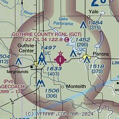
| Sectional chart |
|---|
|
| Airport distance calculator |
|---|
|
|
| Sunrise and sunset |
|---|
|
Times for 23-Jul-2026
| | Local
(UTC-5) | | Zulu
(UTC) |
|---|
| Morning civil twilight | | 05:32 | | 10:32 |
| Sunrise | | 06:04 | | 11:04 |
| Sunset | | 20:44 | | 01:44 |
| Evening civil twilight | | 21:16 | | 02:16 |
|
| Current date and time |
|---|
| Zulu (UTC) | 24-Jul-2026 02:54:42 |
|---|
| Local (UTC-5) | 23-Jul-2026 21:54:42 |
|---|
|
| METAR |
|---|
KPRO
15nm NE | 240235Z AUTO 14004KT 10SM BKN180 20/18 A3010 RMK AO2 T02020185 $
|
KADU
22nm W | 240235Z AUTO 00000KT 10SM 21/18 A3012 RMK AO2 PWINO
|
KCIN
26nm NW | 240235Z AUTO 14005KT 10SM SCT048 SCT085 SCT100 21/18 A3011 RMK AO2
|
|
| TAF |
|---|
KDSM
36nm E | 231729Z 2318/2418 14006KT P6SM FEW040 SCT250 FM240100 11006KT P6SM OVC120 PROB30 2406/2411 4SM -SHRA OVC025 FM241100 13007KT P6SM OVC050 PROB30 2411/2416 4SM -SHRA OVC025 FM241600 15008KT P6SM OVC030
|
|
| NOTAMs |
|---|
NOTAMs are issued by the DoD/FAA and will open in a separate window not controlled by AirNav.
|
|

