FAA INFORMATION EFFECTIVE 09 JULY 2026
Location
| FAA Identifier: | GEO |
| Lat/Long: | 38-52-55.0041N 083-52-57.8520W
38-52.916735N 083-52.964200W
38.8819456,-83.8827367
(estimated) |
| Elevation: | 957.6 ft. / 291.9 m (surveyed) |
| Variation: | 05W (2000) |
| From city: | 1 mile NE of GEORGETOWN, OH |
| Time zone: | UTC -4 (UTC -5 during Standard Time) |
| Zip code: | 45121 |
Airport Operations
| Airport use: | Open to the public |
| Activation date: | 04/1971 |
| Control tower: | no |
| ARTCC: | INDIANAPOLIS CENTER |
| FSS: | DAYTON FLIGHT SERVICE STATION |
| NOTAMs facility: | DAY (NOTAM-D service available) |
| Attendance: | UNATNDD |
| Wind indicator: | lighted |
| Segmented circle: | no |
| Lights: | ACTVT REIL RWY 18 & 36; MIRL RWY 18/36 - CTAF. |
| Beacon: | white-green (lighted land airport)
Operates sunset to sunrise. |
Airport Communications
| CTAF: | 122.9 |
| WX AWOS-3 at I69 (19 nm NW): | 127.275 (513-732-6978) |
- APCH/DEP SVC PRVDD BY INDIANAPOLIS ARTCC ON FREQS 135.575/290.5 (MERWYN RCAG).
Nearby radio navigation aids
| VOR radial/distance | | VOR name | | Freq | | Var |
|---|
| FLMr059/24.4 | | FALMOUTH VOR/DME | | 117.00 | | 04W |
| MXQr191/33.1 | | MIDWEST VOR/DME | | 112.90 | | 04W |
| NDB name | | Hdg/Dist | | Freq | | Var | | ID |
|---|
| SPORTYS | | 131/19.4 | | 245 | | 04W | | PWF | .--. .-- ..-. |
Airport Services
| Fuel available: | 100LL UL94
100LL:FUEL AVBL H24 SELF SVC VIA CREDIT CARD. |
| Parking: | hangars and tiedowns |
| Airframe service: | MINOR
FOR AIRFRAME & POWERPLANT REPAIRS PHONE 937-379-1055. |
| Powerplant service: | MINOR |
| Bottled oxygen: | NONE |
| Bulk oxygen: | NONE |
Runway Information
Runway 18/36
| Dimensions: | 3530 x 65 ft. / 1076 x 20 m |
| Surface: | asphalt, in fair condition |
| Runway edge lights: | medium intensity |
| Runway edge markings: | FADED. |
| RUNWAY 18 | | RUNWAY 36 |
| Latitude: | 38-53.203233N | | 38-52.630235N |
| Longitude: | 083-53.027545W | | 083-52.900865W |
| Elevation: | 955.6 ft. | | 953.3 ft. |
| Traffic pattern: | left | | left |
| Runway heading: | 175 magnetic, 170 true | | 355 magnetic, 350 true |
| Markings: | nonprecision, in poor condition | | nonprecision, in poor condition |
| Visual slope indicator: | 4-light PAPI on left (3.03 degrees glide path) | | 4-light PAPI on left (3.03 degrees glide path) |
| Runway end identifier lights: | yes | | yes |
| Touchdown point: | yes, no lights | | yes, no lights |
| Obstructions: | 100 ft. trees, 1295 ft. from runway, 215 ft. right of centerline, 10:1 slope to clear
3 FT CROPS, 145 FT DIST, 200 FT L TO 180 FT R. | | 45 ft. tree, 260 ft. from runway, 245 ft. right of centerline, 1:1 slope to clear
45-70 FT TREES, 200 FT DIST, 245 FT R. |
Airport Ownership and Management from official FAA records
| Ownership: | Publicly-owned |
| Owner: | BROWN COUNTY COMMISSIONERS
800 MOUNT ORAB PIKE STE 101
GEORGETOWN, OH 45121-1186
Phone 937-378-3956 |
| Manager: | STEVE & SANDY MCKINNEY
8862 AIRPORT RD
GEORGETOWN, OH 45121-8404
Phone 937-483-6212
ADNL CTC: HOME 937-379-1634; BUS 937-379-1055; SPMCKINNEY53@GMAIL.COM. |
Additional Remarks
| - | FOR CD CTC INDIANAPOLIS ARTCC AT 317-247-2411. |
Instrument Procedures
NOTE: All procedures below are presented as PDF files. If you need a reader for these files, you should download the free Adobe Reader.NOT FOR NAVIGATION. Please procure official charts for flight.
FAA instrument procedures published for use from 09 July 2026 at 0901Z to 06 August 2026 at 0900Z.
IAPs - Instrument Approach Procedures |
|---|
| RNAV (GPS) RWY 36 | |
download (194KB) |
| VOR/DME-A | |
download (180KB) |
| NOTE: Special Take-Off Minimums/Departure Procedures apply | |
download (164KB) |
Other nearby airports with instrument procedures:
KAMT - Alexander Salamon Airport (15 nm E)
I69 - Clermont County Airport (19 nm NW)
KFGX - Fleming-Mason Airport (21 nm S)
KHOC - Highland County Airport (24 nm NE)
K62 - Gene Snyder Airport (26 nm SW)
|
|

Road maps at:
MapQuest
Bing
Google
| Aerial photo |
|---|
WARNING: Photo may not be current or correct

Do you have a better or more recent aerial photo of Brown County Airport that you would like to share? If so, please send us your photo.
|
| Sectional chart |
|---|
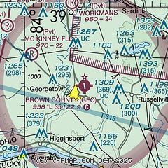
|
| Airport distance calculator |
|---|
|
|
| Sunrise and sunset |
|---|
|
Times for 31-Jul-2026
| | Local
(UTC-4) | | Zulu
(UTC) |
|---|
| Morning civil twilight | | 06:07 | | 10:07 |
| Sunrise | | 06:37 | | 10:37 |
| Sunset | | 20:47 | | 00:47 |
| Evening civil twilight | | 21:17 | | 01:17 |
|
| Current date and time |
|---|
| Zulu (UTC) | 31-Jul-2026 07:13:09 |
|---|
| Local (UTC-4) | 31-Jul-2026 03:13:09 |
|---|
|
| METAR |
|---|
KI69
19nm NW | 310656Z AUTO 00000KT 10SM CLR 20/18 A3007 RMK AO1 T01970183
|
KFGX
21nm S | 310655Z AUTO 28004KT 10SM CLR 19/17 A3008 RMK AO2 T01850165
|
KK62
26nm SW | 310655Z AUTO 00000KT 10SM CLR 17/16 A3006 RMK AO2
|
KLUK
28nm NW | 310653Z AUTO 00000KT 8SM CLR 19/18 A3006 RMK AO2 SLP173 T01890183
|
KILN
33nm N | 310654Z AUTO 00000KT 7SM CLR 17/16 A3007 RMK AO2 SLP174 T01670161 $
|
KCVG
38nm W | 310652Z 00000KT 10SM BKN250 21/17 A3006 RMK AO2 SLP169 T02060172 $
|
|
| TAF |
|---|
KLUK
28nm NW | 310536Z 3106/0106 00000KT P6SM BKN250 FM310700 00000KT 2SM BR BKN250 TEMPO 3109/3112 00000KT 1/4SM FG VV002 FM311300 14005KT P6SM SCT050 BKN250 FM010400 14001KT P6SM BKN090
|
KILN
33nm N | 310536Z 3106/0106 00000KT P6SM SCT250 TEMPO 3109/3112 3SM BR FM311500 17006KT P6SM SCT050 BKN250 FM010000 14003KT P6SM BKN120
|
|
| NOTAMs |
|---|
NOTAMs are issued by the DoD/FAA and will open in a separate window not controlled by AirNav.
|
|


