FAA INFORMATION EFFECTIVE 16 APRIL 2026
Location
| FAA Identifier: | GYH |
| Lat/Long: | 34-45-29.9260N 082-22-35.0900W
34-45.498767N 082-22.584833W
34.7583128,-82.3764139
(estimated) |
| Elevation: | 955.9 ft. / 291.4 m (surveyed) |
| Variation: | 07W (2025) |
| From city: | 6 miles S of GREENVILLE, SC |
| Time zone: | UTC -4 (UTC -5 during Standard Time) |
| Zip code: | 29605 |
Airport Operations
| Airport use: | Open to the public |
| Activation date: | 04/1943 |
| Control tower: | yes |
| ARTCC: | ATLANTA CENTER |
| FSS: | ANDERSON FLIGHT SERVICE STATION |
| NOTAMs facility: | GYH (NOTAM-D service available) |
| Attendance: | 0600-1900 |
| Pattern altitude: | 2755.9 ft. MSL |
| Wind indicator: | lighted |
| Segmented circle: | yes |
| Lights: | ACTVT MALSR RWY 05; HIRL RWY 05/23 - CTAF. |
| Beacon: | white-green (lighted land airport)
Operates sunset to sunrise. |
| Fire and rescue: | ARFF index A |
| Airline operations: | CLSD TO ACR OPNS WITH MORE THAN 30 PSGR SEATS EXCP 24 HR PPR CALL AMGR 864-277-3152. |
Airport Communications
| CTAF: | 133.325 |
| UNICOM: | 122.7 |
| ATIS: | 127.325 |
| WX AWOS-3: | PHONE 864-277-5674 |
| DONALDSON GROUND: | 121.4 [0700-2100] |
| DONALDSON TOWER: | 133.325 269.25 [0700-2100] |
| GREER APPROACH: | 118.8 |
| GREER DEPARTURE: | 118.8 |
| CLEARANCE DELIVERY: | 121.4 |
| BIMMR DP: | 118.8 |
| BWALL DP: | 118.8 |
| WX ASOS at GMU (6 nm N): | 127.075 (864-239-0014) |
| WX ASOS at GSP (11 nm NE): | PHONE 864-334-6232 |
| WX AWOS-3 at LQK (16 nm W): | 120.0 (864-843-5801) |
- APCH/DEP SVC PRVDD BY ATLANTA ARTCC ON FREQS 135.35/263.125 (OWING RCAG) WHEN APCH CTL CLSD.
Nearby radio navigation aids
| VOR radial/distance | | VOR name | | Freq | | Var |
|---|
| SPAr235/27.6 | | SPARTANBURG VORTAC | | 115.70 | | 02W |
| ELWr045/28.6 | | ELECTRIC CITY VORTAC | | 108.60 | | 00E |
| SUGr190/39.3 | | SUGARLOAF MOUNTAIN VORTAC | | 112.20 | | 02W |
Airport Services
| Fuel available: | 100LL JET-A |
| Parking: | hangars and tiedowns |
| Airframe service: | MAJOR |
| Powerplant service: | MAJOR |
| Bottled oxygen: | NONE |
| Bulk oxygen: | HIGH |
Runway Information
Runway 5/23
| Dimensions: | 8000 x 150 ft. / 2438 x 46 m |
| Surface: | concrete/grooved, in good condition |
| Weight bearing capacity: | | Single wheel: | 94.0 | | Double wheel: | 121.0 | | Double tandem: | 199.0 |
|
| Runway edge lights: | high intensity |
| RUNWAY 5 | | RUNWAY 23 |
| Latitude: | 34-44.993448N | | 34-46.004035N |
| Longitude: | 082-23.098127W | | 082-22.071435W |
| Elevation: | 955.8 ft. | | 918.9 ft. |
| Traffic pattern: | right | | left |
| Runway heading: | 047 magnetic, 040 true | | 227 magnetic, 220 true |
| Markings: | precision, in good condition | | precision, in good condition |
| Visual slope indicator: | 4-light PAPI on left (3.22 degrees glide path) | | 4-light PAPI on left (4.14 degrees glide path) |
| Approach lights: | MALSR: 1,400 foot medium intensity approach lighting system with runway alignment indicator lights | | |
| Runway end identifier lights: | no | | |
| Touchdown point: | yes, no lights | | yes, no lights |
| Instrument approach: | ILS/DME | | |
| Obstructions: | none | | 42 ft. trees, 1600 ft. from runway, 650 ft. left of centerline, 33:1 slope to clear |
Airport Ownership and Management from official FAA records
| Ownership: | Publicly-owned |
| Owner: | GREENVILLE CITY/COUNTY
2 EXCHANGE ST
GREENVILLE, SC 29605
Phone (864) 918-8835 |
| Manager: | DANNY MOYD
2 EXCHANGE ST
GREENVILLE, SC 29605
Phone 864-277-3152 |
Additional Remarks
| A39-05/23 | PCR VALUE: 440/R/C/W/T |
| E60-05 | BAK-14 (1502 FT). |
| E60-23 | BAK-14 (1703 FT). |
| - | LTD PRK, RAMP CLSD TO ALL TFC EXC MIL R/W ACFT WITH 24HR PPR. CTC ARNG OPS C803-299-5214. OPR 1230-2200Z++ MON-FRI, EXC HOL. LTD TRAN MAINT FOR CH47 AND UH72 ACFT ONLY. |
| - | ARNG OPS PTD - 41.3 308.7 REMARKS: ARNG OPS C803-299-5214 (GREENVILLE OPS). |
| - | TWY A CLSD TO WINGSPANS GTR THAN 79 FT WO PRIOR CDN WITH ARPT MGMT. |
| - | SFC CONDS NOT RPRTD DAILY 9PM TO 7AM LOCAL. |
Instrument Procedures
NOTE: All procedures below are presented as PDF files. If you need a reader for these files, you should download the free Adobe Reader.NOT FOR NAVIGATION. Please procure official charts for flight.
FAA instrument procedures published for use from 16 April 2026 at 0901Z to 14 May 2026 at 0900Z.
STARs - Standard Terminal Arrivals |
|---|
| JUNNR FOUR (RNAV) | |
download (156KB) |
| MCHLN TWO (RNAV) | |
download (122KB) |
| RCTOR THREE (RNAV) | |
download (125KB) |
| WORXS TWO (RNAV) | |
download (157KB) |
IAPs - Instrument Approach Procedures |
|---|
| ILS OR LOC RWY 05 | |
download (309KB) |
| RNAV (GPS) RWY 05 | |
download (262KB) |
| RNAV (GPS) RWY 23 | |
download (230KB) |
| NOTE: Special Alternate Minimums apply | |
download (167KB) |
Departure Procedures |
|---|
| BIMMR THREE (RNAV) | |
download (180KB) |
| BWALL TWO (RNAV) | |
download (182KB) |
| NOTE: Special Take-Off Minimums/Departure Procedures apply | |
download (355KB) |
Other nearby airports with instrument procedures:
KGMU - Greenville Downtown Airport (6 nm N)
KGSP - Greenville Spartanburg International Airport (11 nm NE)
KLQK - Pickens County Airport (16 nm W)
KSPA - Spartanburg Downtown Memorial Airport/Simpson Field (23 nm NE)
KAND - Anderson Regional Airport (23 nm SW)
|
|

Road maps at:
MapQuest
Bing
Google
| Aerial photo |
|---|
WARNING: Photo may not be current or correct
 Photo by Cathy Vajtay
Photo taken 28-Jun-2015
looking north.
Photo by Cathy Vajtay
Photo taken 28-Jun-2015
looking north.
Do you have a better or more recent aerial photo of Donaldson Field Airport that you would like to share? If so, please send us your photo.
|
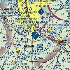
| Sectional chart |
|---|
|
CAUTION: Diagram may not be current
 Download PDF
of official airport diagram from the FAA
| Airport distance calculator |
|---|
|
|
| Sunrise and sunset |
|---|
|
Times for 19-Apr-2026
| | Local
(UTC-4) | | Zulu
(UTC) |
|---|
| Morning civil twilight | | 06:28 | | 10:28 |
| Sunrise | | 06:54 | | 10:54 |
| Sunset | | 20:04 | | 00:04 |
| Evening civil twilight | | 20:30 | | 00:30 |
|
| Current date and time |
|---|
| Zulu (UTC) | 20-Apr-2026 02:55:48 |
|---|
| Local (UTC-4) | 19-Apr-2026 22:55:48 |
|---|
|
| METAR |
|---|
| KGYH | 200235Z AUTO 36009KT 10SM CLR 13/M02 A3019 RMK AO2
|
KGMU
6nm N | 200153Z AUTO 02008KT 10SM CLR 12/M03 A3018 RMK AO2 SLP218 T01221028
|
KGSP
12nm NE | 200153Z 35010G21KT 10SM CLR 14/M04 A3017 RMK AO2 SLP214 T01391044
|
KLQK
16nm W | 200235Z AUTO 06003KT 10SM CLR 07/04 A3018 RMK AO2 T00680042
|
|
| TAF |
|---|
KGMU
6nm N | 191951Z 1920/2018 01011KT P6SM BKN250 FM200000 36009KT P6SM SKC FM200800 27003KT P6SM SKC FM201600 29009G18KT P6SM FEW060
|
KGSP
12nm NE | 192158Z 1922/2018 35009G18KT P6SM SCT250 FM200000 35008KT P6SM SKC FM200800 26003KT P6SM SKC FM201600 28009G18KT P6SM FEW060
|
|
| NOTAMs |
|---|
NOTAMs are issued by the DoD/FAA and will open in a separate window not controlled by AirNav.
|
|


