FAA INFORMATION EFFECTIVE 09 JULY 2026
Location
| FAA Identifier: | HIO |
| Lat/Long: | 45-32-31.6383N 122-57-02.5988W
45-32.527305N 122-57.043313W
45.5421217,-122.9507219
(estimated) |
| Elevation: | 207.9 ft. / 63.4 m (surveyed) |
| Variation: | 16E (2010) |
| From city: | 15 miles SW of PORTLAND, OR |
| Time zone: | UTC -7 (UTC -8 during Standard Time) |
| Zip code: | 97124 |
Airport Operations
| Airport use: | Open to the public |
| Activation date: | 12/1938 |
| Control tower: | yes |
| ARTCC: | SEATTLE CENTER |
| FSS: | MC MINNVILLE FLIGHT SERVICE STATION |
| NOTAMs facility: | HIO (NOTAM-D service available) |
| Attendance: | 0600-2200 |
| Pattern altitude: | TPA: 1000 FT AGL, TURBINE AND LARGE AIRCRAFT 1500 FT AGL. |
| Wind indicator: | lighted |
| Segmented circle: | no |
| Lights: | WHEN ATCT CLSD ACTVT MALSR RWY 13R; PAPI RWY 02 & PAPI RWY 20 - CTAF. |
| Beacon: | white-green (lighted land airport)
Operates sunset to sunrise. |
| Landing fee: | yes, COMMERCIAL ACFT & OPERATORS WITH AN FAA CERTIFIED MAX GROSS LANDING WEIGHT THAT EXCEEDS 10000 LBS ARE REQUIRED TO PAY A LANDING FEE. |
| International operations: | customs landing rights airport |
Airport Communications
| CTAF: | 119.3 |
| UNICOM: | 122.95 |
| ATIS: | 127.65 |
| WX ASOS: | PHONE 503-615-4314 |
| HILLSBORO GROUND: | 121.7 [0600-2200] |
| HILLSBORO TOWER: | 119.3 239.3 132.8 [0600-2200] |
| PORTLAND APPROACH: | 118.1 ;HIGH 126.0 ;LOW |
| PORTLAND DEPARTURE: | 118.1 ;HIGH 126.0 ;LOW |
| HELNS STAR: | 124.35 |
| IC: | 126.0 ;LOW |
| OCITY STAR: | 124.35 |
| WX ASOS at VUO (13 nm E): | 135.125 (360-696-1280) |
| WX ASOS at SPB (14 nm N): | 135.875 (503-543-6401) |
| WX ASOS at PDX (15 nm E): | PHONE 458-212-2405 |
| WX ASOS at UAO (19 nm SE): | 118.525 (503-678-3011) |
Nearby radio navigation aids
| VOR radial/distance | | VOR name | | Freq | | Var |
|---|
| UBGr345/11.4 | | NEWBERG VOR/DME | | 117.40 | | 21E |
| BTGr210/19.5 | | BATTLE GROUND VORTAC | | 116.60 | | 21E |
| NDB name | | Hdg/Dist | | Freq | | Var | | ID |
|---|
| BANKS | | 127/6.6 | | 356 | | 16E | | PND | .--. -. -.. |
Airport Services
| Fuel available: | 100LL JET-A |
| Parking: | hangars and tiedowns |
| Airframe service: | MAJOR |
| Powerplant service: | MAJOR |
| Bottled oxygen: | LOW |
| Bulk oxygen: | HIGH/LOW |
Runway Information
Runway 13R/31L
| Dimensions: | 6600 x 150 ft. / 2012 x 46 m |
| Surface: | asphalt, in good condition |
| Weight bearing capacity: | | Single wheel: | 50.0 | | Double wheel: | 70.0 | | Double tandem: | 110.0 |
|
| Runway edge lights: | high intensity |
| RUNWAY 13R | | RUNWAY 31L |
| Latitude: | 45-32.976495N | | 45-32.102568N |
| Longitude: | 122-57.570283W | | 122-56.652735W |
| Elevation: | 199.9 ft. | | 198.0 ft. |
| Traffic pattern: | left | | left |
| Runway heading: | 127 magnetic, 143 true | | 307 magnetic, 323 true |
| Markings: | precision, in good condition | | nonprecision, in good condition |
| Visual slope indicator: | 4-light PAPI on left (3.00 degrees glide path) | | 4-light PAPI on left (3.00 degrees glide path) |
| RVR equipment: | touchdown | | |
| Approach lights: | MALSR: 1,400 foot medium intensity approach lighting system with runway alignment indicator lights | | |
| Runway end identifier lights: | | | yes |
| Touchdown point: | yes, no lights | | yes, no lights |
| Instrument approach: | ILS | | |
| Obstructions: | none | | 135 ft. tree, 2800 ft. from runway, 200 ft. right of centerline, 19:1 slope to clear |
Runway 2/20
| Dimensions: | 3820 x 75 ft. / 1164 x 23 m |
| Surface: | asphalt, in good condition |
| Weight bearing capacity: | | PCN 20 /F/C/X/T | | Single wheel: | 54.5 | | Double wheel: | 74.0 | | Double tandem: | 139.0 |
|
| Runway edge lights: | medium intensity |
| Operational restrictions: | CLSD TO TOUCH AND GO LNDGS BETWEEN 2200-0600. |
| RUNWAY 2 | | RUNWAY 20 |
| Latitude: | 45-32.042278N | | 45-32.526782N |
| Longitude: | 122-57.117765W | | 122-56.547585W |
| Elevation: | 204.3 ft. | | 207.9 ft. |
| Traffic pattern: | right | | left |
| Runway heading: | 023 magnetic, 039 true | | 203 magnetic, 219 true |
| Markings: | basic, in fair condition | | basic, in fair condition |
| Visual slope indicator: | 4-light PAPI on right (3.00 degrees glide path) | | 4-light PAPI on left (3.00 degrees glide path) |
| Touchdown point: | yes, no lights | | yes, no lights |
| Obstructions: | 15 ft. road, 1370 ft. from runway, 270 ft. right of centerline | | 72 ft. tree, 2105 ft. from runway, 450 ft. left of centerline, 26:1 slope to clear |
Runway 13L/31R
| Dimensions: | 3600 x 60 ft. / 1097 x 18 m |
| Surface: | asphalt, in excellent condition |
| Weight bearing capacity: | | PCN 10 /F/D/Y/T | | Single wheel: | 28.0 |
|
| Runway edge lights: | medium intensity |
| RUNWAY 13L | | RUNWAY 31R |
| Latitude: | 45-33.000850N | | 45-32.524145N |
| Longitude: | 122-57.391990W | | 122-56.891502W |
| Elevation: | 200.6 ft. | | 206.1 ft. |
| Traffic pattern: | left | | right |
| Runway heading: | 128 magnetic, 144 true | | 308 magnetic, 324 true |
| Markings: | basic, in good condition | | basic, in good condition |
| Visual slope indicator: | 4-light PAPI on left (3.00 degrees glide path)
UNUSBL BEYOND 8 DEG L AND R OF RWY CNTRLN | | 4-light PAPI on left (3.00 degrees glide path)
UNUSBL BEYOND 8 DEG L AND R OF RWY CNTRLN |
| Touchdown point: | yes, no lights | | yes, no lights |
Airport Ownership and Management from official FAA records
| Ownership: | Publicly-owned |
| Owner: | THE PORT OF PORTLAND
BOX 3529
PORTLAND, OR 97208
Phone 503-944-7000 |
| Manager: | STEPHEN M. NAGY
THE PORT OF PORTLAND, BOX 3529
PORTLAND, OR 97208
Phone 503-460-4119 |
Additional Remarks
| - | BE ALERT FOR BIRD ACTIVITY IN VICINITY NOV-MAY. |
| - | NIGHTTIME TOUCH AND GOES ARE DISCOURAGED 0600-1400Z++. |
| - | RWY 2-20 HAS 150' X 75' PAVED BLAST PADS AT BOTH ENDS |
| - | RWY 13R-31L HAS 200' X 150' PAVED BLAST PADS AT BOTH ENDS |
| - | GLIDER OPS 5NM NORTHWEST DURING DALGT HOURS MAR-OCT |
| - | BE ALERT EXTV HELICOPTER TRAINING OPERATIONS TO TWY A, TWY B, TWY D. |
| - | FOR CD WHEN TWR CLSD CTC PORTLAND APCH AT 503-493-7545. |
| - | CSTMS AVBL 2000-0400Z++ 503-693-1069, OTHERWISE CSTMS FLT NOTIFICATION SVC (ADCUS) AVBL; ADVANCE COORDINATION REQ 503-326-3230. |
| - | NOISE ABATEMENT PROCEDURES IN EFFECT CALL 503-460-4100 OR 800-938-6647. |
| - | RY 13R RUN-UP AREA NOT VISIBLE FROM ATCT. |
| - | RY 31L IS PREFERRED RY FOR NOISE ABATEMENT. |
| - | NOISE SENSITIVE AREAS BORDER ARPT WEST, SOUTH AND EAST. |
| - | FEE-BASED CSTMS FACILITY: $60 SINGLE-ENGINE, $175 TWIN-ENGINE, $500 TURBINE. |
| - | AVOID LOW-LEVEL OVERFLIGHTS OF RESIDENTIAL AREAS WHENEVER POSSIBLE. |
Instrument Procedures
NOTE: All procedures below are presented as PDF files. If you need a reader for these files, you should download the free Adobe Reader.NOT FOR NAVIGATION. Please procure official charts for flight.
FAA instrument procedures published for use from 09 July 2026 at 0901Z to 06 August 2026 at 0900Z.
STARs - Standard Terminal Arrivals |
|---|
| HELNS SIX **NEW** | |
download (192KB) |
| OCITY THREE **NEW** | |
download (255KB) |
IAPs - Instrument Approach Procedures |
|---|
| ILS OR LOC RWY 13R | |
download (509KB) |
| RNAV (GPS) RWY 13R | |
download (496KB) |
| RNAV (GPS) RWY 31L | |
download (417KB) |
| NDB-B | |
download (288KB) |
| NOTE: Special Alternate Minimums apply | |
download (212KB) |
Departure Procedures |
|---|
| BERNI THREE (RNAV) | |
download (194KB) |
| CANBY TWO | |
download (163KB) |
| CHISM FOUR (RNAV) | |
download (219KB) |
| FARMINGTON SEVEN | |
download (148KB) |
| SCAPO SEVEN | |
download (168KB) |
| NOTE: Special Take-Off Minimums/Departure Procedures apply | |
download (376KB) |
Other nearby airports with instrument procedures:
KVUO - Pearson Field Airport (13 nm E)
KSPB - Scappoose Airport (14 nm N)
KPDX - Portland International Airport (15 nm E)
KUAO - Aurora State Airport (19 nm SE)
KMMV - Mc Minnville Municipal Airport (22 nm S)
|
|

Road maps at:
MapQuest
Bing
Google
| Aerial photo |
|---|
WARNING: Photo may not be current or correct
 Photo by Stefan Eickler
Photo taken 08-Dec-2011
looking northeast.
Photo by Stefan Eickler
Photo taken 08-Dec-2011
looking northeast.
Do you have a better or more recent aerial photo of Portland-Hillsboro Airport that you would like to share? If so, please send us your photo.
|
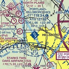
| Sectional chart |
|---|
|
CAUTION: Diagram may not be current
 Download PDF
of official airport diagram from the FAA
| Airport distance calculator |
|---|
|
|
| Sunrise and sunset |
|---|
|
Times for 02-Aug-2026
| | Local
(UTC-7) | | Zulu
(UTC) |
|---|
| Morning civil twilight | | 05:24 | | 12:24 |
| Sunrise | | 05:58 | | 12:58 |
| Sunset | | 20:38 | | 03:38 |
| Evening civil twilight | | 21:12 | | 04:12 |
|
| Current date and time |
|---|
| Zulu (UTC) | 03-Aug-2026 00:25:48 |
|---|
| Local (UTC-7) | 02-Aug-2026 17:25:48 |
|---|
|
| METAR |
|---|
| KHIO | 022353Z 33011G19KT 10SM BKN060 24/09 A3016 RMK AO2 SLP211 T02390089 10239 20183 58015
|
KVUO
13nm E | 022353Z AUTO 28010G17KT 10SM FEW060 24/08 A3017 RMK AO2 SLP217 T02390078 10239 20189 58014
|
KSPB
14nm N | 022353Z AUTO 32009KT 10SM CLR 23/08 A3015 RMK AO2 SLP211 T02330083 10233 20183 58013
|
KPDX
15nm E | 022353Z 29009KT 10SM SCT065 23/09 A3016 RMK AO2 SLP213 T02330094 10239 20189 58015 $
|
KUAO
19nm SE | 022353Z 02009KT 10SM OVC060 22/08 A3017 RMK AO2 SLP216 T02220083 10233 20183 58012
|
|
| TAF |
|---|
| KHIO | 022100Z 0221/0318 33011G21KT P6SM FEW060 FM030600 31009KT P6SM FEW250 FM031100 34004KT P6SM FEW250
|
KPDX
15nm E | 022038Z 0220/0318 31010KT P6SM BKN060 FM030000 32012G22KT P6SM FEW060 FM030600 33009KT P6SM FEW250 FM031000 35004KT P6SM FEW250 FM031700 34009KT P6SM SKC
|
KUAO
19nm SE | 021724Z 0218/0318 VRB04KT P6SM BKN060 FM022200 35010G18KT P6SM FEW100 FM030800 02004KT P6SM SKC FM031500 01009KT P6SM SKC
|
|
| NOTAMs |
|---|
NOTAMs are issued by the DoD/FAA and will open in a separate window not controlled by AirNav.
|
|


