FAA INFORMATION EFFECTIVE 09 JULY 2026
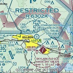
Location
| FAA Identifier: | HLR |
| Lat/Long: | 31-08-15.3264N 097-42-50.7206W
31-08.255440N 097-42.845343W
31.1375907,-97.7140891
(estimated) |
| Elevation: | 910 ft. / 277.4 m (surveyed) |
| Variation: | 05E (2010) |
| From city: | 1 mile NE of FORT HOOD (KILLEEN), TX |
| Time zone: | UTC -5 (UTC -6 during Standard Time) |
| Zip code: | 76544 |
Heliport Operations
| Heliport use: | Private use. Permission required prior to landing |
| Control tower: | yes |
| ARTCC: | FORT WORTH CENTER |
| FSS: | SAN ANGELO FLIGHT SERVICE STATION |
| NOTAMs facility: | SJT (NOTAM-D service available) |
| Attendance: | MON-FRI 1400-0600Z++, EXC HOL |
| Segmented circle: | no |
| Lights: | LGT-MIRL AHP 16-34 OPR 1400-0600++ WKD EXC FED HOL OT PCL 119.65. |
| Beacon: | white-white-green (lighted military airport)
Operates sunset to sunrise. |
Heliport Communications
| ATIS: | 138.6 |
| HOOD GROUND: | 133.85 225.4 [OPR 1400-0600Z++ MON-FRI EXC HOL, OT CTC ROBERT GRAY TWR 120.75 285.5 AIRBORNE;133.85 225.4 ON GND.] |
| HOOD TOWER: | 119.65 269.45 [OPR 1400-0600Z++ MON-FRI EXC HOL, OT CTC ROBERT GRAY TWR 120.75 285.5 AIRBORNE;133.85 225.4 ON GND.] |
| GRAY APPROACH: | 120.075 |
| GRAY DEPARTURE: | 120.075 |
| CLEARANCE DELIVERY: | 225.4 |
| EMERG: | 121.5 243.0 |
| FLT FLW: | 141.175 357.5 |
| PMSV METRO: | 306.5 |
| RANGE CTL: | 30.45 38.3 |
| WX AWOS-3PT at ILE (3 nm SE): | 128.575 (254-892-3293) |
| WX AWOS-3PT at TPL (16 nm E): | 134.975 (254-774-8337) |
| WX AWOS-3PT at GOP (18 nm N): | 119.725 (254-865-6742) |
- PMSV GRAY METRO: FOR REMOTE BRIEFING SVC CTC ROBERT GRAY AAF C254-288-9620, DSN 738-9620 OR 26 OWS, BARKSDALE AFB, C318-529-2651, DSN 331-2651. WX OBSN FULLY AUTOMATED VIA ASOS - C254-286-5692..
Nearby radio navigation aids
| VOR radial/distance | | VOR name | | Freq | | Var |
|---|
| GRKr032/8.1 | | GRAY VOR/DME | | 111.80 | | 07E |
| AGJr092/22.2 | | GOOCH SPRINGS VORTAC | | 112.50 | | 05E |
| ACTr207/38.9 | | WACO VORTAC | | 115.30 | | 09E |
| NDB name | | Hdg/Dist | | Freq | | Var | | ID |
|---|
| IRESH | | 352/6.8 | | 278 | | 05E | | IL | .. .-.. |
Heliport Services
Runway Information
Runway 16/34
| Dimensions: | 2676 x 75 ft. / 816 x 23 m |
| Surface: | asphalt, in good condition |
| Weight bearing capacity: | |
| Runway edge lights: | medium intensity |
| Runway edge markings: | 34 H |
| RUNWAY 16 | | RUNWAY 34 |
| Latitude: | 31-08.466993N | | 31-08.043887N |
| Longitude: | 097-42.918535W | | 097-42.772150W |
| Elevation: | 910.0 ft. | | 883.1 ft. |
| Traffic pattern: | left | | left |
| Markings: | basic, in good condition | | basic, in good condition |
| RVR equipment: | rollout | | touchdown |
| Runway end identifier lights: | no | | no |
| Touchdown point: | yes, no lights | | yes, no lights |
Heliport Ownership and Management from official FAA records
| Ownership: | U.S. Army |
| Owner: | US ARMY
US ARMY AERONAUTICAL SVCS AGENCY, 9325 GUNSTON RD, STE N319
FORT BELVOIR, VA 22060-5582 |
| Manager: | DIRECTORATE OF AVIATION OPERATIONS
BLDG 90029, CLARKE RD
FORT CAVAZOS, TX 76544
Phone 254-288-3811
AMGR; DIR OF AVN OPNS: 254-288-1424 |
Additional Remarks
| - | CAUTION: R6302 LCTD 1.1 NM N OF AFLD. |
| - | TRAN ALERT: LTD TRAN PRK. |
| - | RSTD: PPR ALL TRAN ACFT, C254-288-3811, DSN 738-3811 OR C254-287-7585 DSN 737-7585. RSTD FROM F/W ACFT. |
| - | MISC: NO TRML FCST ISSUED FOR YOAKUM-DEFRENN AHP. |
| - | SEE FLIP AP/1 SUPPLEMENTARY ARPT RMKS. |
| - | CAUTION: SOME ACFT OPR IN AREA WO CONSPICUOUS MRK AND BLEND WITH TERRAIN. |
| - | TFC PAT: LEFT AND RGT TFC ALT 1500'. |
| - | SERVICE - FUEL - A++. RAPID REFUEL OPR TIMES BY NOTAM. |
| - | PMSV GRAY METRO: WX OBSN FULLY AUTOMATED. MANUAL BACK-UP PRVDD FOR EQUIPMENT/COMMUNICATION FAILURE ONLY DURING AFLD OPERATING HRS. |
| - | CAUTION - EXTSV UAS ACT WI CLASS D ASP AND BTN ROBERT GRAY AAF AND R6302. |
| - | HELIPAD (H) ON TWY G PERMLY CLSD. |
| - | COMMUNICATIONS: PHANTOM RDO. |
| - | CAUTION: INST FINAL APCH CRS CROSS 1 NM SW KILLEEN MUNI. |
| - | CAUTION: INTS COPTER OPR VCNTY FT HOOD. |
| - | RSTD: NO BASE OPS SVC AVBL AT YOAKUM-DEFRENN AHP, CTC ROBERT GRAY BASE OPS C254-288-9200, DSN 738-9200. |
| - | OIL: SOAP. |
Instrument Procedures
NOTE: All procedures below are presented as PDF files. If you need a reader for these files, you should download the free Adobe Reader.NOT FOR NAVIGATION. Please procure official charts for flight.
FAA instrument procedures published for use from 09 July 2026 at 0901Z to 06 August 2026 at 0900Z.
IAPs - Instrument Approach Procedures |
|---|
| COPTER RNAV (GPS) RWY 34 | |
download (93KB) |
| COPTER VOR 032 | |
download (110KB) |
| COPTER NDB RWY 34 | |
download (118KB) |
Departure Procedures |
|---|
| CONRA FOUR | |
download (178KB) |
| LAMPS NINE | |
download (203KB) |
| NOTE: Special Take-Off Minimums/Departure Procedures apply **CHANGED** | |
download (291KB) |
Other nearby airports with instrument procedures:
KILE - Skylark Field Airport (3 nm SE)
KGRK - Robert Gray Army Airfield (7 nm SW)
KTPL - Draughon-Miller Central Texas Regional Airport (16 nm E)
KLZZ - Lampasas Airport (25 nm W)
KGTU - Georgetown Executive Airport (28 nm S)
|
|

Road maps at:
MapQuest
Bing
Google
| Aerial photo |
|---|

|
| Sectional chart |
|---|
|
| Airport distance calculator |
|---|
|
|
| Sunrise and sunset |
|---|
|
Times for 17-Jul-2026
| | Local
(UTC-5) | | Zulu
(UTC) |
|---|
| Morning civil twilight | | 06:12 | | 11:12 |
| Sunrise | | 06:40 | | 11:40 |
| Sunset | | 20:34 | | 01:34 |
| Evening civil twilight | | 21:02 | | 02:02 |
|
| Current date and time |
|---|
| Zulu (UTC) | 17-Jul-2026 07:12:18 |
|---|
| Local (UTC-5) | 17-Jul-2026 02:12:18 |
|---|
|
| METAR |
|---|
| KHLR | 170600Z AUTO 15009KT 10SM SCT017 OVC140 25/24 A3009 RMK AO2 SLP179
|
KILE
5nm SE | 170656Z AUTO 15008KT 10SM CLR A3011 RMK AO2 SLPNO FZRANO $
|
KGRK
7nm SW | 170635Z AUTO 13010KT 10SM BKN012 BKN130 25/24 A3010 RMK AO2 CIG 012V140 BKN012 V SCT CIG 011 RWY33 SLP180
|
KTPL
16nm E | 170651Z AUTO OVC013 25/24 RMK AO2 SLPNO T02500239 PWINO RVRNO $
|
KGOP
18nm N | 170655Z AUTO 14007G13KT 10SM BKN013 25/25 A3010 RMK AO2
|
|
| TAF |
|---|
KGRK
7nm SW | 161950Z 1619/1722 16012KT 9999 SCT025 BKN040 QNH3007INS BECMG 1619/1620 14012G18KT 8000 -SHRA BR SCT015 BKN035 QNH3003INS TEMPO 1620/1701 VRB20G30KT 4800 TSRA BR SCT015 OVC030CB BECMG 1702/1703 13012KT 9999 NSW SCT015 BKN035 OVC050 QNH3006INS BECMG 1709/1710 12012KT 4800 -SHRA BR SCT003 OVC010 QNH3009INS TEMPO 1712/1714 0800 FG OVC002 BECMG 1715/1716 16012G18KT 9999 NSW SCT015 BKN060 QNH3007INS TX28/1621Z TN23/1710Z
|
|
| NOTAMs |
|---|
NOTAMs are issued by the DoD/FAA and will open in a separate window not controlled by AirNav.
|
|


