FAA INFORMATION EFFECTIVE 09 JULY 2026
Location
| FAA Identifier: | TPL |
| Lat/Long: | 31-09-06.8415N 097-24-27.5866W
31-09.114025N 097-24.459777W
31.1519004,-97.4076629
(estimated) |
| Elevation: | 682.3 ft. / 208.0 m (surveyed) |
| Variation: | 03E (2020) |
| From city: | 5 miles NW of TEMPLE, TX |
| Time zone: | UTC -5 (UTC -6 during Standard Time) |
| Zip code: | 76502 |
Airport Operations
| Airport use: | Open to the public |
| Activation date: | 07/1942 |
| Control tower: | no |
| ARTCC: | FORT WORTH CENTER |
| FSS: | SAN ANGELO FLIGHT SERVICE STATION |
| NOTAMs facility: | TPL (NOTAM-D service available) |
| Attendance: | 0700-2000
FOR AFT HRS ATNDT 254-493-8530. |
| Wind indicator: | lighted |
| Segmented circle: | yes |
| Lights: | DUSK-2200. ACTVT PAPI RWY 21 - CTAF. AFT 2200 MIRL RWY 16/34 PRESET LOW INTST; TO INCR INTST & ACTVT MALSR RWY 16 - CTAF. MIRL RWY 03/21 NOT AVBL AFT 2200. |
| Beacon: | white-green (lighted land airport)
Operates sunset to sunrise. |
| Airline operations: | ARFF PROTECTION MEETS INDEX B. |
Airport Communications
| CTAF/UNICOM: | 123.0 |
| WX AWOS-3PT: | 134.975 (254-774-8337) |
| GRAY APPROACH: | 120.075 |
| GRAY DEPARTURE: | 120.075 |
| CLEARANCE DELIVERY: | 125.9 |
| WX AWOS-3PT at ILE (15 nm W): | 128.575 (254-892-3293) |
Nearby radio navigation aids
| VOR radial/distance | | VOR name | | Freq | | Var |
|---|
| GRKr064/22.1 | | GRAY VOR/DME | | 111.80 | | 07E |
| ACTr184/31.4 | | WACO VORTAC | | 115.30 | | 09E |
| AGJr088/37.7 | | GOOCH SPRINGS VORTAC | | 112.50 | | 05E |
Airport Services
| Fuel available: | 100LL JET-A JET-A1+
100LL:ALL FUELS FULL & SELF SVC. |
| Parking: | tiedowns |
| Airframe service: | MAJOR |
| Powerplant service: | MAJOR |
| Bottled oxygen: | NONE |
Runway Information
Runway 16/34
| Dimensions: | 7000 x 150 ft. / 2134 x 46 m |
| Surface: | asphalt/grooved, in good condition |
| Weight bearing capacity: | | Single wheel: | 55.0 | | Double wheel: | 70.0 | | Double tandem: | 110.0 |
|
| Runway edge lights: | medium intensity |
| RUNWAY 16 | | RUNWAY 34 |
| Latitude: | 31-09.599500N | | 31-08.497500N |
| Longitude: | 097-24.729667W | | 097-24.328500W |
| Elevation: | 682.3 ft. | | 669.0 ft. |
| Traffic pattern: | left | | left |
| Runway heading: | 160 magnetic, 163 true | | 340 magnetic, 343 true |
| Declared distances: | TORA:7000 TODA:7000 ASDA:7000 LDA:7000 | | TORA:7000 TODA:7000 ASDA:7000 LDA:7000 |
| Markings: | precision, in good condition | | precision, in good condition |
| Visual slope indicator: | | | 4-light PAPI on left (3.00 degrees glide path) |
| Approach lights: | MALSR: 1,400 foot medium intensity approach lighting system with runway alignment indicator lights | | |
| Touchdown point: | yes, no lights | | yes, no lights |
| Instrument approach: | ILS/DME | | |
Runway 3/21
| Dimensions: | 4740 x 100 ft. / 1445 x 30 m |
| Surface: | asphalt, in good condition |
| Weight bearing capacity: | | Single wheel: | 31.0 | | Double wheel: | 37.0 |
|
| Runway edge lights: | medium intensity |
| RUNWAY 3 | | RUNWAY 21 |
| Latitude: | 31-08.864367N | | 31-09.557217N |
| Longitude: | 097-24.568233W | | 097-24.146867W |
| Elevation: | 674.4 ft. | | 665.1 ft. |
| Traffic pattern: | left | | left |
| Runway heading: | 025 magnetic, 028 true | | 205 magnetic, 208 true |
| Declared distances: | TORA:4740 TODA:4740 ASDA:4740 LDA:4740 | | TORA:4740 TODA:4740 ASDA:4740 LDA:4740 |
| Markings: | nonprecision, in good condition | | nonprecision, in good condition |
| Visual slope indicator: | | | 4-light PAPI on left (3.00 degrees glide path) |
| Touchdown point: | yes, no lights | | yes, no lights |
Airport Ownership and Management from official FAA records
| Ownership: | Publicly-owned |
| Owner: | CITY OF TEMPLE
2 N. MAIN
TEMPLE, TX 76501
Phone 254-298-5660 |
| Manager: | SEAN PARKER
7720-F AIRPORT ROAD
TEMPLE, TX 76501
Phone 254-298-5770 |
Additional Remarks
| - | ARFF NOT AVBL 2000-0700. |
| - | MIL CONTR FUEL AVBL. |
| - | GLDR OPS 1.5 MI NORTH OF RWY 16 THR. |
Instrument Procedures
NOTE: All procedures below are presented as PDF files. If you need a reader for these files, you should download the free Adobe Reader.NOT FOR NAVIGATION. Please procure official charts for flight.
FAA instrument procedures published for use from 09 July 2026 at 0901Z to 06 August 2026 at 0900Z.
IAPs - Instrument Approach Procedures |
|---|
| ILS OR LOC RWY 16 **CHANGED** | |
download (256KB) |
| RNAV (GPS) RWY 16 **CHANGED** | |
download (244KB) |
| RNAV (GPS) RWY 34 **CHANGED** | |
download (229KB) |
| NOTE: Special Alternate Minimums apply | |
download (139KB) |
| NOTE: Special Take-Off Minimums/Departure Procedures apply | |
download (294KB) |
Other nearby airports with instrument procedures:
KILE - Skylark Field Airport (15 nm W)
KHLR - Yoakum-Defrenn Army Heliport (16 nm W)
KPWG - Mc Gregor Executive Airport (21 nm N)
KGRK - Robert Gray Army Airfield (22 nm W)
KACT - Waco Regional Airport (29 nm N)
|
|

Road maps at:
MapQuest
Bing
Google
| Aerial photo |
|---|
WARNING: Photo may not be current or correct
 Photo taken 11-Jun-2014
looking northeast.
Photo taken 11-Jun-2014
looking northeast.
Do you have a better or more recent aerial photo of Draughon-Miller Central Texas Regional Airport that you would like to share? If so, please send us your photo.
|
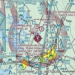
| Sectional chart |
|---|
|
| Airport distance calculator |
|---|
|
|
| Sunrise and sunset |
|---|
|
Times for 31-Jul-2026
| | Local
(UTC-5) | | Zulu
(UTC) |
|---|
| Morning civil twilight | | 06:20 | | 11:20 |
| Sunrise | | 06:47 | | 11:47 |
| Sunset | | 20:25 | | 01:25 |
| Evening civil twilight | | 20:51 | | 01:51 |
|
| Current date and time |
|---|
| Zulu (UTC) | 01-Aug-2026 01:14:51 |
|---|
| Local (UTC-5) | 31-Jul-2026 20:14:51 |
|---|
|
| METAR |
|---|
| KTPL | 010051Z AUTO 19008KT CLR 35/17 A2989 RMK AO2 SLP109 T03500172 PWINO RVRNO $
|
KILE
14nm W | 010056Z AUTO 17007KT 10SM CLR 35/18 A2990 RMK AO2 SLP112 T03500183
|
KHLR
16nm W | 010055Z AUTO 18009KT 10SM CLR 35/18 A2988 RMK AO2 SLP106 T03540184
|
KPWG
19nm N | 010056Z AUTO 18009KT 10SM CLR 36/17 A2988 RMK AO2 SLP108 T03610167
|
|
| TAF |
|---|
KGRK
22nm W | 311602Z 3116/0122 17007KT 9999 SKC QNH2990INS BECMG 0109/0110 22011KT 8000 -SHRA BKN120 QNH2993INS BECMG 0114/0115 25010KT 9999 NSW FEW095 BKN100 QNH2996INS BECMG 0117/0118 29010G15KT 9999 VCTS FEW095 BKN100CB QNH2991INS TX39/3120Z TN24/0112Z
|
|
| NOTAMs |
|---|
NOTAMs are issued by the DoD/FAA and will open in a separate window not controlled by AirNav.
|
|


