FAA INFORMATION EFFECTIVE 14 MAY 2026
Location
| FAA Identifier: | IZG |
| Lat/Long: | 43-59-28.1000N 070-56-52.4000W
43-59.468333N 070-56.873333W
43.9911389,-70.9478889
(estimated) |
| Elevation: | 454.6 ft. / 138.6 m (surveyed) |
| Variation: | 17W (1995) |
| From city: | 3 miles SE of FRYEBURG, ME |
| Time zone: | UTC -4 (UTC -5 during Standard Time) |
| Zip code: | 04037 |
Airport Operations
| Airport use: | Open to the public |
| Activation date: | 10/1961 |
| Control tower: | no |
| ARTCC: | BOSTON CENTER |
| FSS: | BANGOR FLIGHT SERVICE STATION |
| NOTAMs facility: | IZG (NOTAM-D service available) |
| Attendance: | 0800-1700 |
| Wind indicator: | lighted |
| Segmented circle: | yes |
| Lights: | ACTVT MIRL RWY 14/32 - CTAF. |
| Beacon: | white-green (lighted land airport)
Operates sunset to sunrise. |
Airport Communications
| CTAF/UNICOM: | 122.8 |
| WX ASOS: | 135.775 (207-935-2882) |
| PORTLAND APPROACH: | 119.75 |
| PORTLAND DEPARTURE: | 119.75 |
- APCH/DEP SVC PRVDD BY BOSTON ARTCC ON FREQ 128.2/263.05 (WATERBORO RCAG) WHEN PORTLAND ATCT CLSD.
Nearby radio navigation aids
| VOR radial/distance | | VOR name | | Freq | | Var |
|---|
| ENEr354/36.9 | | KENNEBUNK VOR/DME | | 117.10 | | 17W |
| NDB name | | Hdg/Dist | | Freq | | Var | | ID |
|---|
| MAHN | | 142/38.8 | | 386 | | 17W | | GMA | --. -- .- |
Airport Services
| Fuel available: | 100LL JET-A+
100LL:24 HR CREDIT CARD FUEL: FOR 100LL, CALL-OUT FEE; FOR JET A AFT HRS: 207-935-4711 -FBO. |
| Parking: | hangars and tiedowns |
| Airframe service: | MAJOR |
| Powerplant service: | MAJOR |
| Bottled oxygen: | NONE |
| Bulk oxygen: | NONE |
Runway Information
Runway 14/32
| Dimensions: | 4200 x 75 ft. / 1280 x 23 m |
| Surface: | asphalt, in good condition |
| Weight bearing capacity: | |
| Runway edge lights: | medium intensity |
| RUNWAY 14 | | RUNWAY 32 |
| Latitude: | 43-59.673623N | | 43-59.262880N |
| Longitude: | 070-57.257575W | | 070-56.487557W |
| Elevation: | 454.5 ft. | | 420.2 ft. |
| Traffic pattern: | left | | left |
| Runway heading: | 143 magnetic, 126 true | | 323 magnetic, 306 true |
| Markings: | basic, in fair condition | | nonprecision, in fair condition |
| Visual slope indicator: | | | 2-box VASI on left (3.00 degrees glide path)
VASI UNUSBL BYD 7 DEGS L & R OF CNTRLN. |
| Runway end identifier lights: | | | yes |
| Touchdown point: | yes, no lights | | yes, no lights |
| Obstructions: | none | | 55 ft. trees, 2015 ft. from runway, 200 ft. left of centerline, 33:1 slope to clear |
Airport Ownership and Management from official FAA records
| Ownership: | Publicly-owned |
| Owner: | EASTERN SLOPE REGIONAL APT AUTH
BOX 334
FRYEBURG, ME 04037
Phone 207-935-4711 |
| Manager: | ALLISON NAVIA
WHITE MOUNTAIN REGIONAL AIRPORT, PO BOX 334
FRYEBURG, ME 04037
Phone 207-935-4711
AMGR CELL: 207-890-7636. |
Additional Remarks
| - | OBSTN: LGTD HILLS IN APCH TO RWY 14, 4500 FT N, 7000 FT SW, 10000 FT NW. |
| - | BIRDS & DEER ON & INVOF ARPT. |
| - | FOR CD CTC PORTLAND APCH AT 207-874-7320, WHEN APCH CLSD CTC BOSTON ARTCC AT 603-879-6859. |
| - | COLD TEMPERATURE AIRPORT. ALTITUDE CORRECTION REQUIRED AT OR BELOW -28C. |
Instrument Procedures
NOTE: All procedures below are presented as PDF files. If you need a reader for these files, you should download the free Adobe Reader.NOT FOR NAVIGATION. Please procure official charts for flight.
FAA instrument procedures published for use from 14 May 2026 at 0901Z to 11 June 2026 at 0900Z.
IAPs - Instrument Approach Procedures |
|---|
| RNAV (GPS) RWY 32 | |
download (232KB) |
| NOTE: Special Alternate Minimums apply | |
download (150KB) |
| NOTE: Special Take-Off Minimums/Departure Procedures apply | |
download (530KB) |
Other nearby airports with instrument procedures:
81B - Oxford County Regional Airport (22 nm NE)
0B1 - Bethel Regional Airport (27 nm N)
KLEW - Auburn/Lewiston Municipal Airport (29 nm E)
KLCI - Laconia Municipal Airport (32 nm SW)
KHIE - Mount Washington Regional Airport (34 nm NW)
|
|

Road maps at:
MapQuest
Bing
Google
| Aerial photo |
|---|
WARNING: Photo may not be current or correct
 Photo by Jan S. Krouwer
Photo taken 08-Jul-2019
looking west.
Photo by Jan S. Krouwer
Photo taken 08-Jul-2019
looking west.
Do you have a better or more recent aerial photo of White Mountain Regional Airport that you would like to share? If so, please send us your photo.
|
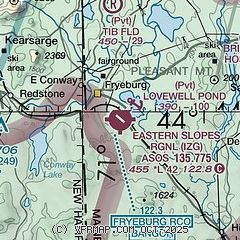
| Sectional chart |
|---|
|
| Airport distance calculator |
|---|
|
|
| Sunrise and sunset |
|---|
|
Times for 24-May-2026
| | Local
(UTC-4) | | Zulu
(UTC) |
|---|
| Morning civil twilight | | 04:36 | | 08:36 |
| Sunrise | | 05:10 | | 09:10 |
| Sunset | | 20:11 | | 00:11 |
| Evening civil twilight | | 20:46 | | 00:46 |
|
| Current date and time |
|---|
| Zulu (UTC) | 24-May-2026 21:27:40 |
|---|
| Local (UTC-4) | 24-May-2026 17:27:40 |
|---|
|
| METAR |
|---|
| KIZG | 242111Z AUTO 00000KT 8SM -RA FEW006 BKN019 OVC025 09/07 A3046 RMK AO2 P0001 T00940072
|
|
| TAF |
|---|
KHIE
34nm NW | 241723Z 2418/2518 15005KT P6SM SCT027 OVC045 TEMPO 2418/2422 6SM -SHRA BR FM242200 14005KT 5SM -SHRA BR OVC026 FM242300 14006KT 5SM BR OVC027 FM250600 VRB04KT 5SM -SHRA BR SCT001 OVC007 FM251600 00000KT P6SM OVC006
|
KPWM
35nm SE | 241723Z 2418/2518 VRB06KT P6SM OVC090 TEMPO 2418/2422 6SM -SHRA BR OVC060 FM242200 VRB04KT 3SM -SHRA BR BKN015 OVC030 FM250000 VRB03KT 5SM -SHRA BR OVC007 FM250700 VRB03KT 1SM -SHRA BR SCT002 OVC005 FM251600 00000KT 5SM BR SCT003 OVC009
|
|
| NOTAMs |
|---|
NOTAMs are issued by the DoD/FAA and will open in a separate window not controlled by AirNav.
|
|


