FAA INFORMATION EFFECTIVE 27 NOVEMBER 2025
Location
| FAA Identifier: | JVL |
| Lat/Long: | 42-37-12.9100N 089-02-29.6410W
42-37.215167N 089-02.494017W
42.6202528,-89.0415669
(estimated) |
| Elevation: | 807.8 ft. / 246.2 m (surveyed) |
| Variation: | 02W (2005) |
| From city: | 3 miles SW of JANESVILLE, WI |
| Time zone: | UTC -6 (UTC -5 during Daylight Saving Time) |
| Zip code: | 53546 |
Airport Operations
| Airport use: | Open to the public |
| Activation date: | 04/1946 |
| Control tower: | yes |
| ARTCC: | CHICAGO CENTER |
| FSS: | GREEN BAY FLIGHT SERVICE STATION |
| NOTAMs facility: | JVL (NOTAM-D service available) |
| Attendance: | 0700-1530
CONDS UNMNT MON-FRI 1530-0700, WKEND & FED HOL. |
| Wind indicator: | lighted |
| Segmented circle: | yes |
| Lights: | ACTVT MALSR RWY 04 & 32; REIL RWY 14 & 22; VASI RWY 32; HIRL RWY 04/22 & 14/32; MIRL RWY 18/36 - CTAF. WHEN ATCT CLSD HIRL RWY 04/22 PRESET TO LOW INTST; INCR INTST - CTAF. PAPI RWY 04, 14, & 22 OPR CONSLY. |
| Beacon: | white-green (lighted land airport)
Operates sunset to sunrise. |
| Fire and rescue: | ARFF index A |
Airport Communications
| CTAF: | 118.8 |
| UNICOM: | 122.95 |
| ATIS: | 128.25 |
| WX AWOS-3: | PHONE 608-758-1723 |
| JANESVILLE GROUND: | 121.65 [0600-2100] |
| JANESVILLE TOWER: | 118.8 225.4 [0600-2100] |
| ROCKFORD APPROACH: | 121.0 |
| ROCKFORD DEPARTURE: | 121.0 |
| CLEARANCE DELIVERY: | 121.65 ;WHEN TWR CLSD 121.65 |
| EMERG: | 121.5 243.0 |
Nearby radio navigation aids
| VOR radial/distance | | VOR name | | Freq | | Var |
|---|
| JVLr034/4.7 | | JANESVILLE VOR/DME | | 114.30 | | 03E |
| MSNr154/34.1 | | MADISON VORTAC | | 108.60 | | 03E |
| NDB name | | Hdg/Dist | | Freq | | Var | | ID |
|---|
| ROCK RIVER | | 204/36.0 | | 371 | | 01W | | RYV | .-. -.-- ...- |
Airport Services
| Fuel available: | 100LL JET-A |
| Parking: | hangars and tiedowns |
| Airframe service: | MAJOR |
| Powerplant service: | MAJOR |
Runway Information
Runway 14/32
| Dimensions: | 7302 x 150 ft. / 2226 x 46 m |
| Surface: | concrete/grooved, in fair condition |
| Weight bearing capacity: | | Single wheel: | 112.0 | | Double wheel: | 147.0 | | Double tandem: | 255.0 |
|
| Runway edge lights: | high intensity |
| Operational restrictions: | RWY 14/32 NOT AVBL FOR PART 121/PART 380 OPS WITH SKED PAX CARRYING OPS MORE THAN 9 PAX SEATS AND NON-SKED PAX CARRYING OPS MORE THAN 30 PAX SEATS. 90 DAY PPR FOR UNSKED ACR OPS GTR THAN 30 PAX SEATS - AMGR. |
| RUNWAY 14 | | RUNWAY 32 |
| Latitude: | 42-37.685253N | | 42-36.856988N |
| Longitude: | 089-03.308983W | | 089-02.129333W |
| Elevation: | 795.1 ft. | | 805.4 ft. |
| Traffic pattern: | left | | left |
| Runway heading: | 136 magnetic, 134 true | | 316 magnetic, 314 true |
| Declared distances: | TORA:7302 TODA:7302 ASDA:7302 LDA:7302 | | TORA:7302 TODA:7302 ASDA:7302 LDA:7302 |
| Markings: | precision, in fair condition | | precision, in good condition |
| Visual slope indicator: | 4-light PAPI on left (3.00 degrees glide path) | | 4-box VASI on left (3.00 degrees glide path) |
| Approach lights: | | | MALSR: 1,400 foot medium intensity approach lighting system with runway alignment indicator lights |
| Runway end identifier lights: | yes | | no |
| Touchdown point: | yes, no lights | | yes, no lights |
| Instrument approach: | | | ILS/DME |
Runway 4/22
| Dimensions: | 6701 x 150 ft. / 2042 x 46 m |
| Surface: | asphalt/grooved, in fair condition |
| Weight bearing capacity: | | Single wheel: | 44.0 | | Double wheel: | 60.0 | | Double tandem: | 105.0, APRONS & RAMPS RSTD TO 155 DTW GROSS WT. |
|
| Runway edge lights: | high intensity |
| Operational restrictions: | RWY 04/22 NOT AVBL FOR PART 121/PART 380 OPS WITH SKED PAX CARRYING OPS MORE THAN 9 PAX SEATS AND NON-SKED PAX CARRYING OPS MORE THAN 30 PAX SEATS. 90 DAY PPR FOR UNSKED ACR OPS GTR THAN 30 PAX SEATS - AMGR. |
| RUNWAY 4 | | RUNWAY 22 |
| Latitude: | 42-36.708663N | | 42-37.534430N |
| Longitude: | 089-02.988857W | | 089-01.998572W |
| Elevation: | 803.7 ft. | | 804.8 ft. |
| Traffic pattern: | left | | left |
| Runway heading: | 044 magnetic, 042 true | | 224 magnetic, 222 true |
| Declared distances: | TORA:6701 TODA:6701 ASDA:6701 LDA:6701 | | TORA:6701 TODA:6701 ASDA:6701 LDA:6701 |
| Markings: | precision, in good condition | | precision, in good condition |
| Visual slope indicator: | 4-light PAPI on left (3.00 degrees glide path) | | 4-light PAPI on left (3.00 degrees glide path) |
| Approach lights: | MALSR: 1,400 foot medium intensity approach lighting system with runway alignment indicator lights | | |
| Runway end identifier lights: | no | | yes |
| Touchdown point: | yes, no lights | | yes, no lights |
| Instrument approach: | ILS | | |
| Obstructions: | none | | 83 ft. tree, 2792 ft. from runway, 367 ft. right of centerline, 31:1 slope to clear |
Runway 18/36
| Dimensions: | 5004 x 75 ft. / 1525 x 23 m |
| Surface: | asphalt, in fair condition |
| Weight bearing capacity: | | Single wheel: | 37.0 | | Double wheel: | 58.0 | | Double tandem: | 104.0 |
|
| Runway edge lights: | medium intensity |
| Operational restrictions: | RWY 18/36 NOT AVBL FOR PART 121/PART 380 OPS WITH SKED PAX CARRYING OPS MORE THAN 9 PAX SEATS AND NON-SKED PAX CARRYING OPS MORE THAN 30 PAX SEATS. 90 DAY PPR FOR UNSKED ACR OPS GTR THAN 30 PAX SEATS - AMGR. |
| RUNWAY 18 | | RUNWAY 36 |
| Latitude: | 42-37.670638N | | 42-36.846910N |
| Longitude: | 089-02.174647W | | 089-02.157233W |
| Elevation: | 807.8 ft. | | 805.7 ft. |
| Traffic pattern: | left | | left |
| Runway heading: | 181 magnetic, 179 true | | 001 magnetic, 359 true |
| Declared distances: | TORA:5004 TODA:5004 ASDA:5004 LDA:5004 | | TORA:5004 TODA:5004 ASDA:5004 LDA:5004 |
| Markings: | basic, in fair condition | | basic, in fair condition |
| Runway end identifier lights: | no | | no |
| Touchdown point: | yes, no lights | | yes, no lights |
| Obstructions: | 16 ft. road, 385 ft. from runway, 20 ft. right of centerline, 11:1 slope to clear | | none |
Airport Ownership and Management from official FAA records
| Ownership: | Publicly-owned |
| Owner: | ROCK COUNTY
51 SOUTH MAIN ST
JANESVILLE, WI 53545
Phone 608-757-5768 |
| Manager: | AIMEE SCRIMA
1716 W. AIRPORT RD
JANESVILLE, WI 53546
Phone 608-757-5768 |
Additional Remarks
| A39-18/36 | PCR VALUE: 130/F/C/X/T |
| A39-14/32 | PCR VALUE: 440/R/B/X/T |
| A39-04/22 | PCR VALUE: 170/R/D/X/T |
| - | LGT SPORT ACFT WITH CRUISE SPEED OF 60 MPH OR LESS ENTER TFC PAT AT 500 AGL. |
| - | RWY 32 & 36 ENDS CLOSELY ALIGNED; VERIFY RWY & HDG BFR DEP. |
Instrument Procedures
NOTE: All procedures below are presented as PDF files. If you need a reader for these files, you should download the free Adobe Reader.NOT FOR NAVIGATION. Please procure official charts for flight.
FAA instrument procedures published for use from 27 November 2025 at 0901Z to 25 December 2025 at 0900Z.
IAPs - Instrument Approach Procedures |
|---|
| ILS OR LOC RWY 04 | |
download (281KB) |
| ILS OR LOC RWY 32 | |
download (279KB) |
| RNAV (GPS) RWY 04 | |
download (307KB) |
| RNAV (GPS) RWY 14 | |
download (296KB) |
| RNAV (GPS) RWY 22 | |
download (285KB) |
| RNAV (GPS) RWY 32 | |
download (291KB) |
| NOTE: Special Alternate Minimums apply | |
download (140KB) |
| NOTE: Special Take-Off Minimums/Departure Procedures apply | |
download (201KB) |
Other nearby airports with instrument procedures:
44C - Beloit Airport (8 nm SE)
C77 - Poplar Grove Airport (20 nm SE)
61C - Fort Atkinson Municipal Airport (23 nm NE)
KEFT - Monroe Municipal Airport (24 nm W)
KRFD - Chicago/Rockford International Airport (26 nm S)
|
|

Road maps at:
MapQuest
Bing
Google
| Aerial photo |
|---|
WARNING: Photo may not be current or correct
 Taken in the Summer of 2009
Do you have a better or more recent aerial photo of Southern Wisconsin Regional Airport that you would like to share? If so, please send us your photo.
|
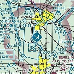
| Sectional chart |
|---|
|
CAUTION: Diagram may not be current

| Airport distance calculator |
|---|
|
|
| Sunrise and sunset |
|---|
|
Times for 30-Nov-2025
| | Local
(UTC-6) | | Zulu
(UTC) |
|---|
| Morning civil twilight | | 06:35 | | 12:35 |
| Sunrise | | 07:06 | | 13:06 |
| Sunset | | 16:23 | | 22:23 |
| Evening civil twilight | | 16:55 | | 22:55 |
|
| Current date and time |
|---|
| Zulu (UTC) | 30-Nov-2025 16:25:43 |
|---|
| Local (UTC-6) | 30-Nov-2025 10:25:43 |
|---|
|
| METAR |
|---|
| KJVL | 301545Z 33012G18KT 10SM OVC021 M02/M04 A3012
|
|
| TAF |
|---|
| KJVL | 301120Z 3012/0112 32014G24KT 1SM -SN BLSN OVC008 FM301400 32014G24KT 3SM -SN BLSN BKN007 FM301600 32014G23KT 6SM BLSN BKN013 FM301900 33013G21KT P6SM BLSN BKN022 FM302000 32009KT P6SM BKN027 FM302300 32008KT P6SM BKN045 FM011100 00000KT P6SM BKN035
|
|
| NOTAMs |
|---|
NOTAMs are issued by the DoD/FAA and will open in a separate window not controlled by AirNav.
|
|


