FAA INFORMATION EFFECTIVE 09 JULY 2026
Location
| FAA Identifier: | LUD |
| Lat/Long: | 33-15-15.3000N 097-34-49.8000W
33-15.255000N 097-34.830000W
33.2542500,-97.5805000
(estimated) |
| Elevation: | 1046.7 ft. / 319.0 m (surveyed) |
| Variation: | 03E (2025) |
| From city: | 2 miles N of DECATUR, TX |
| Time zone: | UTC -5 (UTC -6 during Standard Time) |
| Zip code: | 76234 |
Airport Operations
| Airport use: | Open to the public |
| Activation date: | 01/1947 |
| Control tower: | no |
| ARTCC: | FORT WORTH CENTER |
| FSS: | FORT WORTH FLIGHT SERVICE STATION |
| NOTAMs facility: | LUD (NOTAM-D service available) |
| Attendance: | 0800-1700 |
| Wind indicator: | lighted |
| Segmented circle: | yes |
| Lights: | DUSK-DAWN. MIRL RWY 17/35 PRESET LOW INTST; TO INCR INTST ACTVT - CTAF. |
| Beacon: | white-green (lighted land airport)
Operates sunset to sunrise. |
Airport Communications
| CTAF/UNICOM: | 122.8 |
| WX AWOS-3: | 118.225 (940-627-2365) |
| LONE STAR APPROACH: | 118.1 |
| LONE STAR DEPARTURE: | 118.1 |
| BOTCH DP: | 118.1 |
| DODJE STAR: | 125.2 125.9 |
| GARLAND DP: | 118.1 |
| JOE POOL DP: | 118.1 |
| LIKES STAR: | 125.8 ;SOUTH 135.975 ;NORTH |
| MOTZA STAR: | 118.1 ;SOUTH 125.8 ;NORTH |
| REEKO STAR: | 125.2 |
| SASIE STAR: | 124.3 |
| TRUUK RNAV STAR: | 124.3 |
| WESAT STAR: | 118.1 ;SOUTH 125.8 ;NORTH |
| WX AWOS-3PT at XBP (13 nm W): | 119.225 (940-683-8027) |
| WX ASOS at DTO (19 nm E): | 119.325 (940-354-2971) |
Nearby radio navigation aids
| VOR radial/distance | | VOR name | | Freq | | Var |
|---|
| UKWr138/20.8 | | BOWIE VORTAC | | 117.15 | | 06E |
| FUZr311/29.8 | | RANGER VORTAC | | 115.70 | | 06E |
| TTTr304/35.7 | | MAVERICK VOR/DME | | 113.10 | | 06E |
| MQPr025/38.0 | | MILLSAP VORTAC | | 117.70 | | 09E |
Airport Services
| Fuel available: | 100LL JET-A |
| Parking: | hangars and tiedowns |
| Airframe service: | MAJOR |
| Powerplant service: | MAJOR |
| Bulk oxygen: | NONE |
Runway Information
Runway 17/35
| Dimensions: | 4200 x 60 ft. / 1280 x 18 m |
| Surface: | asphalt, in good condition |
| Weight bearing capacity: | | Single wheel: | 12.5 | | Double wheel: | 17.0 |
|
| Runway edge lights: | medium intensity |
| RUNWAY 17 | | RUNWAY 35 |
| Latitude: | 33-15.597737N | | 33-14.911167N |
| Longitude: | 097-34.883468W | | 097-34.775153W |
| Elevation: | 1041.2 ft. | | 1036.9 ft. |
| Traffic pattern: | left | | right |
| Runway heading: | 169 magnetic, 172 true | | 349 magnetic, 352 true |
| Markings: | nonprecision, in fair condition | | nonprecision, in fair condition |
| Visual slope indicator: | 2-light PAPI on left (3.50 degrees glide path) | | 2-light PAPI on left (3.50 degrees glide path) |
| Runway end identifier lights: | yes | | |
| Touchdown point: | yes, no lights | | yes, no lights |
| Obstructions: | 10 ft. tree, 243 ft. from runway, 125 ft. right of centerline, 4:1 slope to clear
30 FT TREES, 0-199 FT DSTC, 245 FT L, 151 FT R. | | 28 ft. pline, marked, 760 ft. from runway, 230 ft. right of centerline, 20:1 slope to clear
20 FT TREES, 140-199 FT DSTC, 150-250 FT R. |
Airport Ownership and Management from official FAA records
| Ownership: | Publicly-owned |
| Owner: | CITY OF DECATUR
PO BOX 1299
DECATUR, TX 76234
Phone 940-393-0200 |
| Manager: | GREG HALL
351 AIRPORT ROAD
DECATUR, TX 76234
Phone 940-627-2855
DIR OF PUBLIC WORKS/AMGR ADDNL PHONE: 940-393-0262. |
Additional Remarks
| - | GND DROPS SHARPLY 160 FT NORTH OF RWY 17 THR. |
| - | DEER AND WILDLIFE ON & INVOF ARPT. |
| - | FOR CD CTC LONE STAR APCH AT 972-615-2799. |
| - | DUE TO RWY ELEV CHG, ACFT NOT VSB AT OPPOSITE END. |
Instrument Procedures
NOTE: All procedures below are presented as PDF files. If you need a reader for these files, you should download the free Adobe Reader.NOT FOR NAVIGATION. Please procure official charts for flight.
FAA instrument procedures published for use from 09 July 2026 at 0901Z to 06 August 2026 at 0900Z.
STARs - Standard Terminal Arrivals |
|---|
| DODJE SIX **NEW** | |
2 pages:
[1] [2] (673KB) |
| LIKES FOUR (RNAV) **NEW** | |
download (192KB) |
| MOTZA ONE **NEW** | |
2 pages:
[1] [2] (424KB) |
| REEKO THREE (RNAV) **NEW** | |
download (214KB) |
| SASIE EIGHT **NEW** | |
2 pages:
[1] [2] (437KB) |
| TRUUK THREE (RNAV) **NEW** | |
download (198KB) |
| WESAT THREE (RNAV) **NEW** | |
download (210KB) |
IAPs - Instrument Approach Procedures |
|---|
| RNAV (GPS) RWY 17 **CHANGED** | |
download (206KB) |
| RNAV (GPS) RWY 35 **CHANGED** | |
download (213KB) |
| NOTE: Special Alternate Minimums apply | |
download (21KB) |
Departure Procedures |
|---|
| BOTCH TWO (RNAV) **NEW** | |
2 pages:
[1] [2] (351KB) |
| GARLAND SIX | |
2 pages:
[1] [2] (326KB) |
| JOE POOL EIGHT | |
2 pages:
[1] [2] (439KB) |
| KINGDOM FIVE | |
2 pages:
[1] [2] (349KB) |
| KUSSO THREE (RNAV) **NEW** | |
2 pages:
[1] [2] (329KB) |
| NANDR FOUR (RNAV) **NEW** | |
2 pages:
[1] [2] (316KB) |
| NOTE: Special Take-Off Minimums/Departure Procedures apply | |
download (301KB) |
Other nearby airports with instrument procedures:
KXBP - Bridgeport Municipal Airport (13 nm W)
4T2 - Kenneth Copeland Airport (17 nm S)
KDTO - Denton Enterprise Airport (19 nm E)
KAFW - Perot Field/Fort Worth Alliance Airport (21 nm SE)
0F2 - Bowie Municipal Airport (23 nm NW)
|
|

Road maps at:
MapQuest
Bing
Google
| Aerial photo |
|---|
WARNING: Photo may not be current or correct

Do you have a better or more recent aerial photo of Decatur Municipal Airport that you would like to share? If so, please send us your photo.
|
| Sectional chart |
|---|
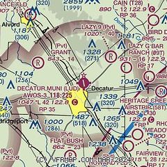
|
| Airport distance calculator |
|---|
|
|
| Sunrise and sunset |
|---|
|
Times for 15-Jul-2026
| | Local
(UTC-5) | | Zulu
(UTC) |
|---|
| Morning civil twilight | | 06:05 | | 11:05 |
| Sunrise | | 06:33 | | 11:33 |
| Sunset | | 20:40 | | 01:40 |
| Evening civil twilight | | 21:08 | | 02:08 |
|
| Current date and time |
|---|
| Zulu (UTC) | 16-Jul-2026 03:09:58 |
|---|
| Local (UTC-5) | 15-Jul-2026 22:09:58 |
|---|
|
| METAR |
|---|
| KLUD | 118.22 940-927-2365
160255Z AUTO 18005KT 10SM CLR 24/20 A3007 RMK AO2 T02380198
|
KXBP
13nm W | 160230Z AUTO 17005KT CLR 23/20 A3007 RMK AO2 T02300196 PWINO
|
KDTO
19nm E | 160253Z AUTO 15006KT 10SM CLR 25/21 A3006 RMK AO2 SLP170 T02500211 53008
|
|
| TAF |
|---|
KAFW
22nm SE | 152206Z 1522/1618 19010KT P6SM SCT025 BKN100 TEMPO 1603/1606 BKN025 FM161400 16004KT P6SM BKN020 FM161600 18006KT P6SM OVC120
|
|
| NOTAMs |
|---|
NOTAMs are issued by the DoD/FAA and will open in a separate window not controlled by AirNav.
|
|


